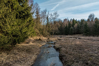
Schafbach (Elbbach)
| Schafbach | ||
|
The Schafbach near Höhn |
||
| Data | ||
| Water code | DE : 258762 | |
| location |
Westerwald (natural area)
|
|
| River system | Rhine | |
| Drain over | Elbbach → Lahn → Rhine → North Sea | |
| source | in the Westerwald basalt plateau south of Höhn - Neuhochstein 50 ° 37 ′ 11 ″ N , 7 ° 56 ′ 49 ″ E |
|
| Source height | 477 m above sea level NHN | |
| muzzle | at the hammer mill south of Gemünden in the Elbbach Coordinates: 50 ° 32 ′ 40 ″ N , 8 ° 0 ′ 53 ″ E 50 ° 32 ′ 40 ″ N , 8 ° 0 ′ 53 ″ E |
|
| Mouth height | 238 m above sea level NHN | |
| Height difference | 239 m | |
| Bottom slope | 18 ‰ | |
| length | 13.6 km | |
| Catchment area | 46.682 km² | |
The Schafbach is about thirteen and a half kilometers long left tributary of the Elbbach in the Westerwald . Until 1270 the brook was called Hene , from which the place name Höhn is derived.
geography
course
The Schafbach arises in a meadow landscape from two spring branches in the Westerwald basalt plateau south of Höhn - Neuhochstein . The stream initially flows in a south-westerly direction along the northern edge of a forest . After leaving the forest, it is fed by the Schönberger Bach . It passes under the B 255 and then moves south through a wooded area. It then flows past the Ahlsberg to the left and is reinforced shortly afterwards on its right by the Walzenbach and immediately afterwards on the left by the Binnbach . To the north of Halbs the stream flows from the Heerstrut to him. The Schafbach makes a wide arc around Halbs and then disappears piped into the underground, only to reappear about 200 meters north of Hergenroth . It passes the village and is fed a little later by the Seebach . After about 400 meters, a mill ditch branches off the stream , which used to be used by the Klöcknersmühle . The Schafbach now reaches the northern edge of Westerburg , where it reunites with the Mühlgraben. The Hülsbach falls to it near the market square in Westerburg . Its direction of flow is now the southeast. He leaves the local area, he turns abruptly to the east and flows along the southern edge of the city. After a good 900 meters, it changes to the southeast, passes a forest and then crosses under the L 288 . It now moves through a landscape of fields and meadows and flows, lined with trees, past the stone bridge mill and the Jeremiah mill. From there it runs about 600 meters parallel to the Elbbach , into which it finally flows at the hammer mill .
Tributaries
| Surname | GKZ | location | Length in km |
EZG in km² |
|---|---|---|---|---|
| Schoenberger Bach | 25876212 | Left | 1.0 | 1.428 |
| Walzenbach | 2587622 | right | 1.5 | 2,298 |
| Binnbach | Left | 1.6 | ||
| Bach vom Heerstrut | 2587624 | right | 1.1 | 0.975 |
| Seebach | 2587626 | Left | 7.4 | 18,132 |
| Hülsbach | 2587628 | right | 3.4 | 5.984 |
Elbbach river system
Individual evidence
- ↑ a b Map service of the landscape information system of the Rhineland-Palatinate Nature Conservation Administration (LANIS map) ( notes )
- ↑ a b Map service of the Geoportal Wasser Rheinland-Pfalz
- ^ Karl Kessler, Wolfgang Reinhardt: Great Westerwaldführer . Ed .: Hermann-Josef Hucke [editor]. 3. Edition. Verlag Westerwald-Verein eV, Montabaur 1991, ISBN 3-921548-04-7 , p. 108-109 .
- ^ City map service
