
Schanzenberg (Granitz)
| Schanzenberg | ||
|---|---|---|
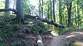
 The Schanzenberg in the Granitz: View southwest over the northern part of the wall, 2015 |
||
| Alternative name (s): | Schanzenort, formerly another 2 small flanking ramparts Silvitzer Ort and Kathrinenberge | |
| Creation time : | Bronze age | |
| Castle type : | Heights / refuge castle | |
| Conservation status: | Wall remains | |
| Geographical location | 54 ° 24 '3 " N , 13 ° 40' 7.1" E | |
|
||

The Schanzenberg is a rampart in the Granitz forest area in the southeast of the island of Rügen .
Location and description

In the southeast of the island of Rügen, the Granitz extends as a group of wooded heights. In the Granitz, Grümbke names three ramparts, all three of which are not far from the sea on the banks of the Silvitzer and Granitzer villages. The word "Granitz" indicates a square, wooden border marking, from which a name for the border itself later developed (see also Granica ). Why the forest area got this name is unknown. The name "Silvitzer Ort" seems to point to a lost town. The middle wall, the Schanzenberg or also called Schanzenort, is located near the black lake and faces the Falkenberger Ufer. Overgrown with trees and bushes, the wall is difficult to find. The semicircular complex is located on a hill that nature itself has formed as a wall. The slope of the rampart meets the sloping depression, the mountain slope, so exactly that it just seems to be a whole. Grümbke further describes that there are two other, smaller fortifications on both sides of this larger complex. One is to the west, not far from the village of Silvitz (around the coordinates 54.399433N | 13.634216O). To the east, the other is located behind the Kathrinenberge (coordinates 54.388352N | 13.687731O), roughly in the middle between Granitzer Ort and Quitzlaser Ort. In fact, the Schanzenberg is located on the eastern bank of the Granitzer Ort, which, consistent with Grümbke's description, bears the name Schanzenort (coordinates 54.400842N | 13.668644O). The area, protected by the rampart on a ledge, is around 200 × 150 meters. Inside the system, the wall is 2 to 3 meters high, outside the system 5 to 9 meters high. The location allows a wide view both to the north and to the south. Excavations that could provide further results have not yet taken place. The wall is located not far northwest of the Falkenberger Ufer. As according to Grümbke's description, the site is difficult to recognize due to the topography of the area and lies on an existing ridge, which is additionally increased or reinforced by the wall. In the northwest and northeast end of the wall there are two entrances through which the high bank path runs. The north-western entrance was clearly marked in 2015 by a tree trunk that was bent almost horizontally above the entrance. To the south of this access there are two further whale incisions on the west side of the facility. These two breakthroughs are recorded on the measuring table sheet 376, 316a: Middelhagen (detail) (west and north of I). They seem to give access to the different levels behind the wall. In the wall area just behind the north-eastern entrance there are two square concrete foundations of unknown function, making this entrance easy to find. To the south there is another breakthrough through the eastern wall. The bank edge, which surrounds the ramparts, descends relatively gently towards the water, so that the cliff area is almost completely forested. On the basis of this topographical feature, the coastal erosion in this area will have been delayed and thus the maintenance of the system was favored. The wall at the Silvitzer Ort called by Grümbke is no longer there due to continual bank falls. Due to these reasons, the system behind the Kathrinenberge is only available on a small ledge. According to Alfred Haas , the external features, similar to the saddle on the stallion , served as an excellent observation point (castrum speculatorium) for the sea areas spreading north-east. Both points could have monitored the situation in the Prorer Wiek together. The area between Silvitzer Ort and Granitzer Ort is called "Kieköwer" or "Kieküber". It is also plausible to him that next to the wall at the Silvitzer Ort on the other side of the Granitzer Ort there was a similar lookout wall on the Katharinen Mountains, while the Schanzenberg, as a refuge for the population, was located between the two protective walls . Due to the lack of historical references to the origins of the fortifications, Haas concludes that they date from prehistoric times.

history
In the Neolithic developed in the hilly, interspersed with valleys, the area south of the Granitz between the Rügischer Bodden of Lauterbach Bay , the Having and Lake Sellin a closed settlement area , which until the outgoing Iron Age is used continuously. Knapp suspects a Bronze Age refuge in the hill town . In the Granitz itself, the lack of further ground monuments is striking, although the land around is littered with prehistoric tombs. V. Hagenow therefore suspects that the Granitz is a primeval forest or that religious aspects in the form of a sacred grove are responsible for this lack. Compared to the Stubnitz , the accumulation of large stone and tumulus graves as border marks in the immediate vicinity of the Granitz Forest supports the assumption that the aforementioned defenses were used in the Bronze Age.
Popular tradition
The folklorist Alfred Haas narrates the fairy tale in his book from 1903 as follows:
- “ The castle sunk in the black lake .
- In the Granitz, between the Jagdschloss and Sellin, there is a small lake in a quiet forest seclusion, which is popularly known as the Black Lake . Hundreds of years ago, a magnificent castle and all of its inhabitants sank into this lake. Only the lord of the castle, who happened to be hunting at the same time, got away with his life. When he wanted to return to the castle after the hunt was over, he found the lake at the place where it had stood, and of all the splendors that he had left a few hours before, he saw nothing more than a chair, which swam around on the lake near the shore. On the chair were his gloves, which he had left behind when he left the castle to hunt. Now he remembered it, and involuntarily he reached for the gloves; but no sooner had he taken it than the chair sank into the depths. If he had taken the chair instead of the gloves, the whole castle with all its inhabitants would have come back to the surface and been redeemed.
- However, the lock can still be redeemed in the following ways:
- When the day on which the castle once sank into the depths, it comes up to the surface of the water. If someone then has the courage to step across the water and enter the castle, it is redeemed. And he does not need to be afraid that he will sink, because on this day the water has the strength that it carries whoever wants to redeem the castle and holds it on the surface.
- On New Year's Eve you can hear the cheers of the castle residents echoing from the depths of the water. Sometimes they are so loud that the whole forest echoes them. "
This legend can be found in a very similar version on Serpin and on Lake Herthasee . From tradition, Haas suspects, like the other two places, that a pagan place of worship could have been on the shores of the Black Lake .

The Schanzenberg in the Granitz: View westwards to the northeast entrance of the wall on Uferweg, 2015
The Schanzenberg in the Granitz: View west to the north-western entrance of the wall on Uferweg, 2015


literature
- Nils Petzholdt: Rügen's pre-Slavic castle complexes In: Pomerania. Journal of Culture and History. Issue 1/2016, ISSN 0032-4167 , pp. 4–13. or Nils Petzholdt: Rügen's vorwendische Wehranlagen In: Stralsund booklets for history, culture and everyday life, Stralsund 2016, ISBN 978-3-95872-039-8 , pp. 97-107.
Individual evidence
- ^ Oskar Beyersdorff , Slavic Stripes, in: Baltic Studies AF 33, Stettin 1883, pp. 58–62
- ^ Johann Jacob Grümbke : New and precise geographical-statistical-historical representations of the island and the principality, Rügen 1819, Volume 2, pp. 220-221
- ^ Reichsamt für Landesaufnahme, Mestischblatt 376, 316 a: Middelhagen, recording 1885, published 1887, individual supplements 1909, 1: 25000, Berlin 1909
- ↑ Ingrid Schmidt, Hünengrab and Sacrificial Stone, Rostock 2001, p. 75
- ^ Alfred Haas : The Granitz on Rügen, in: Baltic Studies NF 20, Stettin 1917, pp. 14-16
- ^ Wilhelm Petzsch : Die Steinzeit Rügen, in: Communications from the collection of patriotic antiquities of the University of Greifswald 3, Greifswald 1928, pp. 7–156
- ^ Elsbeth Lange , Lebrecht Jeschke and Hans Dieter Knapp: Ralswiek and Rügen, Landscape Development and Settlement History of the Baltic Sea Island, Part I - The Landscape History of the Island of Rügen since the Late Glacial, in Writings on Prehistory and Early History, Volume 38, Berlin 1986, p. 139 -143
- ↑ Hans Dieter Knapp: Rügen's story from its beginnings to the present in five parts, part 1: Rügen's early history, Putbus 2008, p. 120
- ^ Friedrich von Hagenow : von Hagenow's map of Rügen, in: Neue Pommersche Provinzblätter, Volume 3, edited by Ludwig Giesebrecht and Johann Christian Ludwig Haken , Stettin 1828, pp. 319-320
- ^ Alfred Haas : Rügen legends and fairy tales . 3. Edition. Johs. Burmeister, Stettin 1903, XV. Lost cities, castles, palaces and churches. 143. The castle sunk in the black lake, p. 132-133 ( online in the Internet Archive).
- ^ Alfred Haas : The Granitz on Rügen, in: Baltic Studies NF 20, Stettin 1917, pp. 49-50