
Notch (geography)
A notch in the geographical sense is a term used in geomorphology and describes a ridge cut. The course of the watershed between two mountains or a distinctive edge of the terrain is called a ridge or ridge . The notch height is an important feature for describing the independence of a mountain.
Only particularly rugged and forbidding terrain cuts are referred to as gaps, otherwise one speaks of a saddle . Saddles are generally not mobile, but are occasionally crossed by mule tracks or stepped on when crossing a ridge.
For example, the highest gorge in Austria, the "Obere Glocknerscharte" ( 3766 m above sea level ), connects the Klein- ( 3783 m above sea level ) with the Grossglockner ( 3798 m above sea level ), which gives the Kleinglockner a minimal one Notch height of 17 m. The gap is about 8 m wide and connects the two peaks with a mostly overgrown snow ridge , often only two feet wide . The saddle is entered on the normal route from the Adlersruhe to the Großglockner, it serves as an exit from the “Pallavicini Gully” (ice up to 55 ° steep) from the north and is almost never climbed from the south. Hardly anyone would think of crossing the Glockner massif via this gap.
The vast majority of the notches are unnamed and are almost never entered or only entered in the course of ridge ascents. So every ridge tower ("gendarme") forms a notch. Many double peaks are separated by striking notches. The large number of notches also gave the Lyskamm (Lauskamm) its name.
The boundary to other names for ridge cuts such as yoke or saddle ("Col") is fluid and varies greatly locally.
Other well-known notches are:
- "Langkofelscharte" in the Langkofel group
- the "Brèche-nord des Dames Anglaises" (about 3,600 m) and the "Col de Peuterey" ( 3934 m slm ) on the Peuterey ridge on Mont Blanc
- "Hohe Dachsteinscharte" ( 2874 m above sea level ) between Hohem and Niederer Dachstein.
- the notches between the five points over 4000 m in the "Devil's Ridge" on the Mont Blanc du Tacul
- the Brèche de Roland in the Pyrenees
- " Bettlerscharte " in the Venediger group
Images of notches
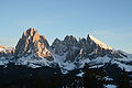
Langkofel group with the clearly visible, distinctive Langkofelscharte left of center

Brèche de Roland in the Pyrenees

Multiform massif Cerro Torre and Fitz Roy


swell
- ↑ Willi End , Hubert Peterka : Alpine Club Leader Glockner and Granatspitz Group , Bergverlag Rudolf Rother, Munich 1990. ISBN 3-7633-1258-7 [1]