
Mont Blanc
| Mont Blanc | ||
|---|---|---|
 Mont Blanc from east-northeast |
||
| height | 4810 m | |
| location | France and Italy | |
| Mountain range | Mont Blanc group | |
| Dominance | 2812 km → Kjukjurtlju | |
| Notch height | 4697 m ↓ At the Kubenasee | |
| Coordinates | 45 ° 49 '57 " N , 6 ° 51' 52" E | |
|
||
| rock | granite | |
| First ascent | August 8, 1786 , Jacques Balmat and Michel-Gabriel Paccard | |
| Normal way | High tour from Refuge du Goûter | |
| particularities | Highest mountain in the Alps | |

The Mont Blanc [ mõˈblɑ̃ ] (also Montblanc , Italian Monte Bianco [ ˌmonteˈbi̯aŋko ], translated 'white mountain') on the border between France and Italy is at 4810 m the highest mountain in the Alps and the EU . Whether this or the Elbrus (5642 m) in the Russian Caucasus is the highest mountain in Europe depends on the definition of the inner Eurasian border . Since 2000, the Mont Blanc massif has been on France's list of proposed UNESCO World Heritage sites .
location
 | |
Location of Mont Blanc in the Mont Blanc group, within the entire Alps, see right. |
Mont Blanc is part of the Mont Blanc group , a mountain group of the Western Alps , which in turn is inconsistently classified under the Graian Alps or the Savoy Alps .
Both France and Italy have a stake in the mountain, with the borderline being controversial for a long time. France claims the summit region of Mont Blanc for the French department Haute-Savoie , which also takes on the mountain rescue and administration. Italy is of the opinion that the border runs exactly over the summit . Thus, according to the Italian point of view, Mont Blanc would be both the highest mountain in France and Italy, but according to the French point of view, the upstream Mont Blanc de Courmayeur ( 4748 m ) would be the highest peak in Italy.
In the north of Mont Blanc lies the Arve valley with the tourist center of Chamonix . This place is also one of the most important bases for climbing the mountain. In the north-west there are two other important starting points for tours on Mont Blanc, Saint-Gervais-les-Bains and Les Houches, and the Italian town of Courmayeur in the Aosta Valley in the south-east .
topography


The Mont Blanc is made of granite and has two completely different faces: in the north it is rounded and almost completely glaciated, from the south it appears as a striking rock with steep walls. To the northwest, he sends the Bossesgrat toward the behind the saddle Col du Dôme lying Dôme du Goûter ( 4303 m ) and the Aiguille du Gouter ( 3863 m ) to the northeast the Connection Ridge unto the footmen Mont Maudit and Mont Blanc du Tacul . To the south run two wild rock ridges that reach down over 3500 meters into the Italian Val Veny , the Brouillard ridge (in the west) and the Peuterey ridge (in the east), in between the shorter Innominatagrat and the three Frêneypeiler (from left to right Harlinpeiler , central Frêneyppeiler, Gervasutti pillar ).
The Mont Blanc is heavily glaciated due to its height and the high amounts of precipitation. The glaciers flowing down from Mont Blanc reach the flat valley floor on the Italian south side, with the peculiarity that their circumference has hardly shrunk in the past 150 years ( Glacier / Ghiacciaio de Miage , Glacier / Ghiacciaio de / della Brenva). On the French north side, the Glacier des Bossons flows from the summit down to 1,420 meters (2007) and thus also almost reaches the valley floor. The resulting difference in altitude of 3390 meters is the greatest difference in altitude in the Alps that a glacier can overcome.
The highest alpine peak is one of the most prominent (topographically) mountains of all. Its notch height of 4697 m is only surpassed by ten peaks worldwide. Its prominence saddle (reference saddle), which is 113 m high, is located near Lake Kubena in northern Russia . If you want to reach a higher and more prominent mountain via this saddle without descending any deeper, you get to Mount Everest , which is both the Prominence Master and the Island Parent reference mountain for Mont Blanc. The next higher mountains, on the other hand, are in the Caucasus . The Kjukjurtlju is the dominance reference mountain for Mont Blanc.
height

Since the summit consists of firn and ice , its height and shape are subject to natural fluctuations depending on the weather and the season. Overall, however, it is relatively stable compared to other firn peaks and changes by around ± 1.5 meters over the years.
According to measurements by the Laboratoire de Glaciologie et Géophysique de l'Environnement (LGGE) of the CNRS Grenoble together with the ETH Zurich in 2004, the height of the highest rock point on Mont Blanc was 4792 m above this point thick layer of snow and ice measured.
The firn summit of the mountain is not immediately above this point, but to the west of it, where the firn cover is thicker. Its location changes due to the weather, so that it migrated about 26 meters to the east between 2007 and 2009. Its height also fluctuates: For example, the first GPS measurement by the French surveying authority Institut géographique national (IGN) in 2001 measured 4,808.4 m . In 2007 the Mont Blanc reached almost 4811 m , in 2009 4810.45 m were measured and in 2015 it was again 4808.73 m . The height of Mont Blanc is therefore often given differently.
Geology, climate, flora and fauna

Highest mountain in Europe?
The question of whether Mont Blanc is also the highest mountain in Europe and thus one of the Seven Summits depends on the course of the not clearly defined Inner Eurasian border : If the watershed of the main ridge of the Caucasus is viewed as the border between the continents, then the Elbrus ( 5642 m) and several other Caucasus peaks in Europe and thus represent the highest elevations on this continent. If, on the other hand, the Manytsch lowlands are viewed as the border, then these mountains are in Asia , making Mont Blanc the highest mountain in Europe. In mountaineering circles today, Elbrus is mostly seen as the highest mountain in Europe.
Paths to the summit

The ascent most frequently climbed today, the normal route , leads from the northwest side over the Aiguille du Goûter and the Dôme du Goûter to the summit. A frequent starting point for this route is the Nid d'Aigle ( eagle's nest ) viewpoint , the terminus of the Tramway du Mont Blanc cog railway at 2386 m . The refuges Refuge de Tête Rousse and Refuge du Goûter can be used as bases . From the Col du Dôme the path leads over the Abri de Vallot bivouac box ( 4362 m ), below which there is a small observatory, and the Bosses ridge to the summit.
Another popular route is the one from the Aiguille du Midi ( 3842 m ) and the Refuge des Cosmiques ( 3613 m ) via the Mont Blanc du Tacul and Mont Maudit, which can be reached by cable car . This tour is usually carried out in the form of a crossing to the Refuge du Goûter .
The route over the Refuge des Grands Mulets ( 3,051 m ) and the Col du Dôme is often used as a descent variant or as a ski tour in spring . A variant leads over the north ridge of the Dôme du Goûter.
Another route from France is that of Les Contamines-Montjoie , crossing the Dômes de Miage , the Aiguille de Bionnassay and the Dome du Goûter with overnight stays in the Refuge des Conscrits and Refuge Durier huts , a well-known climb from the Italian side leads over the Miagegletscher and the Rifugio Francesco Gonella (3071 m).
In addition to these relatively easy climbs, there are several rock and ice climbing routes, some of which are extremely difficult .
story

First explorations
Mont Blanc was first mentioned as Les Glaciers in 1581 . In 1606 it and its glaciers were shown on a map for the first time. In this it is referred to as Montagne Maudite ("Cursed Mountain"), a name that later passed on to its neighboring summit, Mont Maudit . First measurements in 1727 showed a height of 4276 m , in 1745 it was described by Geneva researchers as the highest mountain in Europe.
In 1741, the Mont Blanc massif first became known throughout Europe through the explorations of Richard Pococke and William Windham. Serious ascent attempts were not made, however, as popular belief still considers the mountain to be a "cursed mountain" and to enter it as extremely dangerous. In folk tales, dragons, ghosts, cities punished for their arrogance or even the devil were suspected under its glaciers.
In 1760, the Geneva naturalist Horace Bénédict de Saussure came to Chamonix for the first time and offered a reward for the first ascent . At that time, the focus of interest was on scientific issues and less sporting goals. Marc Théodore Bourrit then tried several times to reach the summit, but failed. However, his travelogues contributed significantly to the increasing popularity of the mountain. Further attempts were made up to 1774, including by Saussure himself, with various climbs being attempted from the (later) French side, but also from the Valdostan side. In 1775 a group with the doctor Michel-Gabriel Paccard and the crystal seeker Jacques Balmat , both from Chamonix, reached the 4000 m high Grand Plateau northwest of the mountain for the first time . No serious attempts followed until 1783, when the mountain guide Jean-Marie Couttet and the hunter Cuidet reached the Dôme du Goûter in 1784 . In the following years there was heated debate as to whether the route from Saint-Gervais via the Aiguille du Goûter or the ascent from Chamonix via the Bosson glacier was better. On the Saint-Gervais route, the first high-alpine refuge in the Alps was built near Pierre Ronde in 1785 .
On June 8, 1786, two groups, one from Saint-Gervais and one from Chamonix, climbed the Col du Dôme, the saddle between Mont Blanc and Dôme du Goûter, and met there. Jacques Balmat, who had joined the Chamonix group without being asked, was separated from the others while trying to find another way over the Bosses ridge and had to bivouac with insufficient equipment at 4000 m altitude near the Grand Plateau . Until then, all attempts at ascent had been attempted from relatively low heights, as overnight stays on the glacier had not been considered possible, also for reasons of superstition; Balmat's successful first high-altitude glacier bivouac refuted this opinion.
First ascents
On August 7, 1786, Jacques Balmat and Michel-Gabriel Paccard set out from Chamonix and stayed at the Gîte à Balmat , a rock formation near the Bossons glacier at approx. 2300 m . The next day, starting at 4 a.m., they ascended over the Jonction glacier break , the Grands Mulets , the Grand Plateau and the northern flank of Mont Blanc. At 6:23 p.m. they were the first to reach the summit.
The nobles Adolf Traugott von Gersdorff and Karl Andreas von Meyer zu Knonow , who were from Upper Lusatia in Saxony and were on a research trip to Chamonix at the time, witnessed the first ascent. Both made drawings of the first ascent route. Gersdorff also recorded a detailed report in his travel diary. These documents, which are important for the history of mountaineering, are now kept in the Görlitz Cultural History Museum and the Upper Lusatian Library of Sciences in Görlitz.
Today, the first ascent of Mont Blanc is seen as one of the birth hours of modern alpinism and an expression of people's dwindling fear of the dangers of the mountains and a turn to nature in the Rococo .
Another first ascent of Mont Blanc took place first of all by her rope team on July 24, 1875 by the honorary member from Grindelwald of the British Alpine Club , Tschingel (1865–1879), who was the first female to reach the summit on her own. In Chamonix, this event was closely followed from afar. After successfully reaching the summit, a cannon shot was fired in the village and an honorary parade through the village and a reception for more than 100 people, including all mountain guides present in the area, were prepared for the entire rope team on their return.
Further ascents

In 1787 Balmat climbed the mountain for the second time with another group, on August 3, during the third ascent, he led Horace Saussure to the summit, who also carried out scientific experiments there.
In 1808, Marie Paradis was the first woman to climb the mountain, although she was partly carried by Jacques Balmat. In 1838 Henriette d'Angeville was finally able to reach the summit on her own.
On July 18, 1861, the mountain guide Johann Joseph Benet (1824–1864) from Steinhaus, together with Leslie Stephen and FF Tuckett with Melchior Anderegg and Peter Perren, managed the first ascent of Mont Blanc via today's normal route, which went as far as the Col du Dôme in 1784 committed by Cuttet and Cuidet.
In the 1860s, the sporting aspect of ascents became more important. The record for the Chamonix-Mont-Blanc-Chamonix route (via the Gouter route) was reduced from 16 hours to 8:48 hours between 1865 and 1868. Kilian Jornet 's current record from 2013 is 4:57 hours, the record on skis was set by Stéphane Brosse and Pierre Gignoux in 2003 with 5:15 hours.
Aviation accidents
- On November 3, 1950, was Lockheed L-749 Constellation of Air India ( air vehicle registration VT-CQP ) in descent to the Geneva airport flew in the Mont Blanc and crashed. The machine was on the flight from Bombay via Cairo and Geneva to London. All 48 occupants were killed (see Air India Flight 245 ) .
- On January 24, 1966, this accident was largely repeated. A Boeing 707-437 of Air India (VT-DMN) was en route from Bombay to New York . During the descent to the planned stopover in Geneva , she was flown into Mont Blanc and crashed about 60 m below the summit on a rock ridge. All 117 people on board (106 passengers and 11 crew members) were killed (see Air India flight 101 ) . The plane crashed at almost the same point on the mountain as Air India Flight 245 on November 3, 1950.
panorama

Illustrations
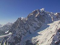
East side of Mont Blanc photographed from a glider

North side of Mont Blanc, taken at the Col de l'Index (2420 m)

Mont Blanc from Brevent seen from
Dôme du Goûter as seen from the Gare des Glaciers

Mont Blanc from the Valais

The Mont Blanc seen from the limestone plateau of the "Désert de Platé"

The north flank of Mont Blanc du Tacul, Mont Maudit and Mont Blanc (from left to right) from the viewing terrace in the summit area of the Aiguille du Midi

Mont Blanc photographed from an airplane, west side


See also
- Ultra-Trail du Mont-Blanc : Ultra- marathon that runs counter-clockwise on trails from Chamonix around the Mont-Blanc group. With a route length of approx. 168 km, more than 9000 meters of altitude to be overcome and a time limit of 46 hours, it is one of the most demanding mountain marathons in the world.
- Mont Blanc tunnel
literature
- Stefano Ardito: Mont Blanc. Conquering a mountain range. K. Müller, Erlangen 1996, ISBN 3-86070-294-7 .
- Stefano Ardito: Conquering the Giants. From the first ascent of Montblanc to free climbing. Bucher, Munich 2002, ISBN 3-7658-1258-7 .
- François Damilano: Mont Blanc. 5 routes to the summit. JM-Editions, Chamonix 2004, ISBN 2-9521881-0-6 .
- Helmut Dumler, Willi P. Burkhardt: Four thousand meter peaks in the Alps. 12th, updated edition. Bergverlag Rother, Munich 2001, ISBN 3-7633-7427-2 .
- Hartmut Eberlein: Mont Blanc Group. Area guides for hikers, mountaineers and climbers (= area guides for mountaineers and climbers ). 10th edition. Bergverlag Rother, Munich 2005, ISBN 3-7633-2414-3 (written according to the guidelines of the UIAA ).
Web links
- Mont Blanc at 4000m - the four-thousanders of the Alps. Ed .: Thomas Schabacher , Daniel Roth
- Mont Blanc on GeoFinder.ch
- Mont Blanc on the ETHorama platform
- Panorama of Mont Blanc on In2White , in record resolution with 365 gigapixels
- Early Alpine Images: Mont Blanc 1786–1827
- Google Maps: Explore Mont Blanc
Individual evidence
- ↑ Duden entry on Montblanc
- ↑ Massif du Mont Blanc. UNESCO World Heritage Center, June 8, 2000, accessed January 15, 2018 (French).
- ↑ Eberhard Jurgalski et al .: The most prominent peaks on earth. (xls; 63 kB) peaklist.org , March 22, 2008, accessed on January 5, 2016 (English).
- ↑ See list of the most prominent mountains in the Alps .
- ^ Damilano: Mont Blanc. 2004, p. 23.
- ↑ a b c The Mont Blanc has shrunk. (No longer available online.) Nürnberger Nachrichten , formerly in the original ; Retrieved November 8, 2009 . ( Page no longer available , search in web archives ) Info: The link was automatically marked as defective. Please check the link according to the instructions and then remove this notice.
- ↑ Eberlein: Mont Blanc Group. 10th edition. 2005, pp. 88-89.
- ^ Damilano: Mont Blanc. 2004, pp. 64-79.
- ↑ Eberlein: Mont Blanc Group. 10th edition. 2005, pp. 92-93.
- ^ Damilano: Mont Blanc. 2004, pp. 83-104.
- ↑ a b Eberlein: Mont Blanc Group. 10th edition. 2005, pp. 89-92.
- ^ Damilano: Mont Blanc. 2004, pp. 108-157.
- ↑ Pointdexter, Joseph: Between heaven and earth. The 50 highest peaks. Könemann, Cologne 1999, ISBN 3-8290-3561-6 , p. 135
- ↑ a b Mont Blanc. World of Mountains, accessed January 5, 2015 .
- ↑ a b Karl Gratzl: The Myth of the Mountain. Lexicon of the important mountains from mythology, cultural history and religion. Hollinek, Purkersdorf 2000, ISBN 3-85119-280-X , pp. 252-254.
- ↑ a b c Pointdexter, Joseph: Between heaven and earth. The 50 highest peaks. Könemann, Cologne 1999, ISBN 3-8290-3561-6 , p. 130
- ^ Damilano: Mont Blanc. 2004, pp. 34-44.
- ^ Gaston Rébuffat : Montblanc. The 100 ideal tours in the Montblanc massif. BLV-Verlagsgesellschaft et al., Munich et al. 1975, ISBN 3-405-11485-3 , pp. 12-13.
- ↑ Ardito: Mont Blanc. 1996, p. 49. They started the descent at 6:47 pm.
- ↑ Caroline Fink: First ascent on four paws: A dog's life for the mountains. In: Neue Zürcher Zeitung . August 29, 2014. Retrieved June 29, 2016 .
- ↑ Pointdexter, Joseph: Between heaven and earth. The 50 highest peaks. Könemann, Cologne 1999, ISBN 3-8290-3561-6 , p. 131
- ↑ Eberlein: Mont Blanc Group. 10th edition. 2005, p. 88.
- ↑ Mont-Blanc Summit Speed Record Smashed! July 11, 2013, accessed January 5, 2015.
- ^ Damilano: Mont Blanc. 2004, p. 87.
- ^ Accident report L-749 VT-CQP , Aviation Safety Network (English), accessed on November 23, 2017.
- ^ Accident report B-707 VT-DMN , Aviation Safety Network (English), accessed on December 1, 2017.
Africa: Kibo | Antarctica: Mount Vinson | Asia: Mount Everest | Australia / Oceania: Mount Kosciuszko • Puncak Jaya | Europe: Mont Blanc • Elbrus | North America: Denali | South America: Aconcagua