Schils (river)
| Schils | ||
|
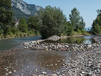
The confluence of the Schils (right in the picture) into the Seez near Flums and Walenstadt |
||
| Data | ||
| Water code | CH : 350 | |
| location | Canton of St. Gallen ; Switzerland | |
| River system | Rhine | |
| Drain over | Seez → Linth → Limmat → Aare → Rhine → North Sea | |
| Headwaters | Line between Spitzmeilen and Wissgandstöckli 47 ° 0 '8 " N , 9 ° 14' 50" O |
|
| Source height | 2306 m above sea level M. | |
| muzzle | at Flums in the Seez coordinates: 47 ° 6 ′ 15 ″ N , 9 ° 20 ′ 2 ″ E ; CH1903: 743 845 / 218 760 47 ° 6 '15 " N , 9 ° 20' 2" O |
|
| Mouth height | 432 m above sea level M. | |
| Height difference | 1874 m | |
| Bottom slope | 12% | |
| length | 16.2 km | |
| Catchment area | 55.85 km² | |
| Discharge at the estuary A Eo gauge : 55.85 km² |
MQ Mq |
1.97 m³ / s 35.3 l / (s km²) |
| Left tributaries | Matossabach, Tobelbach | |
| Communities | Flums , Walenstadt | |
The Schils is a roughly 16 kilometer long left tributary of the Seez in the Swiss canton of St. Gallen . It flows through the Schilstal , a side valley of the Seez Valley , and drains an area of around 56 square kilometers. The river runs mainly in the municipality of Flums , only the mouth is in the municipality of Walenstadt .
course
The Schils rises on a ridge between the Spitzmeilen and the Wissgandstöckli at 2306 m above sea level. M. directly on the border with the canton of Glarus . The river runs in a north-easterly direction through the valley to the village of Flums, which it touches in the west. It now flows northwest in a straightened river bed, takes up the Tobelbach and flows northeast of the Gräpplang Castle at 432 m above sea level. M. in the also straightened Seez.
use
The St. Gallisch-Appenzellische Kraftwerke (SAK) operate a hydropower plant on the course of the Schils, including a small reservoir below the Bruggwiti sawmill.
Web links
Individual evidence
- ↑ a b c Geoserver of the Swiss Federal Administration ( information )
- ↑ a b Modeled mean annual discharge. In: Topographical catchment areas of Swiss waters: sub-catchment areas 2 km². Retrieved August 10, 2017 .
- ↑ Schils hydropower plant on the SAK website
