Pointed miles
| Pointed miles | ||
|---|---|---|
|
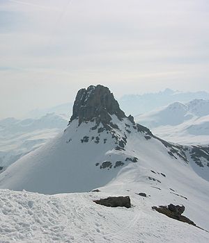
Northwest side of Spitzmeilen from Wissmilen |
||
| height | 2501 m above sea level M. | |
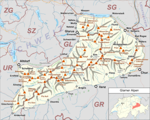
| location | Canton Glarus / Canton St. Gallen , Switzerland | |
| Mountains | Glarus Alps | |
| Dominance | 1.35 km → Magerrain | |
| Notch height | 81 m ↓ Wissmilenpass | |
| Coordinates | 736 655 / 209670 | |
|
|
||
| rock | Lias lime | |
| Normal way | Demanding mountain hike from Flumserberg | |
|
summit |
||
|
The normal route to the Spitzmeilen summit with a chain as a climbing aid |
||
The Spitzmeilen is a 2501 m above sea level. M. high mountain in the Glarus Alps . It lies on the border between the Swiss cantons of Glarus and St. Gallen .
The Spitzmeilen is known for its imposing shape, the actual summit stick protrudes as a steep rock tooth from the slopes below. That is why it can be seen from afar and some restaurants in the area have names such as Spitzmeilenblick. It is also used as a "landmark" by the Flumserberg ski area, although it is not accessible by train. The summit is made of brown lias limestone .
In the immediate north-western neighborhood is the 2483 m above sea level. M. slightly lower Wissmilen , which leads over the Wissmilenpass to the Magerrain ( 2524 m above sea level ). All three are located on the northern edge of the UNESCO World Heritage Site Tectonic Arena Sardona .
North of Spitzmeilen is the Flumserberg ski area , from where the summit can be climbed as a day tour. As a starting point for the inspection, the 2087 m above sea level can also M. located Spitzmeilenhütte ( SAC ) serve. Another access from the Glarus side is Engi , located in the Sernftal valley . The key point in the ascent is the steep rock summit, which is reached through a channel (couloir) in the east side. Easy climbing ( difficulty level I.–II. ) is required. In winter, the Spitzmeilen is a popular destination for ski tours .
Web links
- Mountain and ski tours on the Spitzmeilen on hikr.org
- Spitzmeilenhütte SAC with a short route description
Individual evidence
- ^ Charles Knapp, Maurice Borel, Victor Attinger, Heinrich Brunner, Société neuchâteloise de geographie (editor): Geographical Lexicon of Switzerland . Volume 5: Switzerland - Tavetsch . Verlag Gebrüder Attinger, Neuenburg 1908, p. 656, keyword Spitzmeilen ( scan of the lexicon page ).


