
Narrow horn
| Narrow horn | ||
|---|---|---|
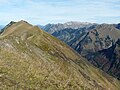
 View over the Enzianhütte to the Schmalhorn (from the left the first Grasberg), in front of it the Einödsberg. In the background on the right the Höfats |
||
| height | 1952.4 m above sea level NHN | |
| location | Bavaria , Germany | |
| Mountains | Central main ridge , Allgäu Alps | |
| Dominance | 0.6 km → Hinterer Wildgundkopf | |
| Notch height | 53 m ↓ notch to the rear Wildgundkopf | |
| Coordinates | 47 ° 20 '2 " N , 10 ° 17' 15" E | |
|
||
| First ascent | by locals | |

The Schmalhorn is a 1952 m high mountain in the Allgäu Alps . The inconspicuous mountain lies in the Himmelschrofenzug between the Hinteres Wildgundkopf and the saddle zone of the Einödsberg . On the Schmalhorn, the border of the transition from the main dolomite in the north to the softer spotted marl in the south runs. The height of the Schmalhorn is at least 52 meters, its dominance 600 meters, with the Hintere Wildgundkopf being the reference mountain.
Ascent
There is no marked path leading to the Schmalhorn. However, it can be reached easily from Einödsberg. The further way north to the Hinteren Wildgundkopf is pathless and requires mountain experience.
Narrow horn. In front of it the alpine hut Auf der Egge

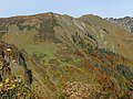
Almhütte Auf der Egge with Schmalhorn and Höfats (right).
Schmalhorn (right) from the pilgrimage chapel Maria am Knie


literature
- Thaddäus Steiner : Allgäuer Bergnames , Lindenberg, Kunstverlag Josef Fink, 2007, ISBN 978-3-89870-389-5
- Thaddäus Steiner: The field names of the municipality of Oberstdorf im Allgäu , Munich, self-published by the Association for Field Name Research in Bavaria, 1972
- Zettler / Groth: Alpine Club Guide Allgäu Alps . Bergverlag Rudolf Rother , Munich 1984. ISBN 3-7633-1111-4
Web links
Remarks
- ↑ Exact value not known, stated value is a minimum value (can be up to 19 meters higher). It was determined from the distance between the contour lines (20 meters in altitude ) on a topographic map ( scale 1: 25,000).