
Schochenspitze
| Schochenspitze | ||
|---|---|---|
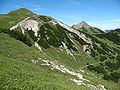
 Landsberger hut in front of the Schochenspitze |
||
| height | 2069 m above sea level A. | |
| location | Tyrol , Austria | |
| Mountains | Vilsalpseeberge , Allgäu Alps | |
| Dominance | 1.3 km → Lachenspitze | |
| Notch height | 154 m ↓ Eastern Lachenjoch | |
| Coordinates | 47 ° 27 '8 " N , 10 ° 31' 27" E | |
|
||
| rock | Aptych lime | |
| Normal way | Landsberger Hut - Eastern Lachenjoch | |

The Schochenspitze is a 2069 meter high mountain in the Allgäu Alps that rises in Austria .
Location and surroundings
The Schochenspitze is located in the Austrian state of Tyrol and in the municipality of Tannheim .
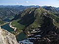
The summit of the Schochenspitze rises east of the Traualpsee (1630 m) and between the Sulzspitze (2084 m) in the northeast and the Lachenspitze (2126 m) in the southwest. It is separated from these two mountains by the Gappenfeldscharte (1860 m) and the Eastern Lachenjoch (1915 m). The latter goes over to the Lachenspitze and is the reference point for the gap height of 154 meters. The dominance is also determined by the Lachenspitze and is 1.3 kilometers. To the east lies the furthest valley of the Weißenbach with the Gappenfelder Notländ between Schochenspitze and Leilachspitze (2274 m).
From the Schochenspitze a ridge stretches to the north, bearing the small elevation of the Paleness (1961 m), before the flanks descend to the Vilsalpsee (1165 m). This secondary peak is insignificant, but it is perceived from the valley around the Vilsalpsee because the main peak is covered.
geology
In the summit area, the Schochenspitze consists of aptych limestone from the Malm period with embedded Raibler layers . Layers of Lias marl and radiolarite lie underneath . The aptych layers are a calcareous - marly rock . They are mainly made up of coccoliths and have aptychs as key fossils .
Origin of name
A Schochen was first mentioned in the hunting book of Emperor Maximilian in 1500. In 1557 it was mentioned in a border description with Sulzspitze, next to the Schochen . "Schochen" is the medieval name for a cone-shaped haystack that was piled up overnight to dry the hay.
Ascent
The normal route to the Schochenspitze leads from the Vilsalpsee on path 425 up to the Landsberger hut (1805 m) and from there on path 421 to the northeast to the eastern Lachenjoch and to the summit. An alternative normal route is the ascent from the Neunerköpfle. This can be reached with a cable car . From there a high path runs to the Strindenscharte (1870 m) and on the Saalfelder Höhenweg under the Sulzspitze to the Gappenfeldscharte and on to the summit. A longer ascent is also possible from Rauth through the Weißenbach valley up to the Gappenfelder Notländ.
In addition, there are pathless and unmarked ascent possibilities, some of which also have to be climbed. The direct ascent from the Traualpsee has the difficulty III . Climbing over the north ridge is in the IV degree.
In winter, the Schochenspitze is a ski touring destination that is approached from the Landsberger Hütte and from the Sulzspitze.
photos
Above the Gappenfelder Notländ

From the southwest

From the northeast
South view


Web links
Individual evidence
- ↑ a b Compass hiking, bike and ski tour map: Sheet 04 Tannheimer Tal (1: 35,000). ISBN 978-3-85491-644-4 (as of February 2007).
- ↑ Federal Office for Metrology and Surveying Austria: Austrian Map online . Retrieved May 8, 2010.
- ^ A b Ernst Zettler, Heinz Groth: Alpine Club Guide - Allgäu Alps . 12th, completely revised edition. Bergverlag Rudolf Rother , Munich 1985, ISBN 3-7633-1111-4 (p. 462ff).
- ^ Herbert Scholz: Building and Becoming the Allgäu Landscape . E. Schweizerbart'sche Verlagbuchhandlung (Nägele and Obermiller), Stuttgart 1995, ISBN 3-510-65165-0 (pp. 55ff).
- ^ Thaddäus Steiner : Allgäu mountain names . 2nd Edition. Kunstverlag Josef Fink, Lindenberg 2008, ISBN 978-3-8987-0389-5 (p. 186).
- ↑ Dieter Seibert: Alpine Club Guide alpine - Allgäu Alps and Ammergau Alps . 17th edition. Bergverlag Rother, Munich 2008, ISBN 978-3-7633-1126-2 (p. 270).
- ↑ Kristian Rath: Allgäu ski tour guide with Kleinwalsertal and Tannheimer Tal . 6th edition. Panico Alpinverlag, Köngen 2009, ISBN 978-3-9367-4010-3 (pp. 191, 193).