Cabinet wall
|
Schranawand ( village ) locality cadastral community Schranawand |
||
|---|---|---|
|
|
||
| Basic data | ||
| Pole. District , state | Baden (BA), Lower Austria | |
| Judicial district | to bathe | |
| Pole. local community | Ebreichsdorf | |
| Coordinates | 47 ° 58 '45 " N , 16 ° 26' 36" E | |
| height | 192 m above sea level A. | |
| Residents of the village | 200 (January 1, 2020) | |
| Area d. KG | 6.49 km² | |
| Statistical identification | ||
| Locality code | 03421 | |
| Cadastral parish number | 04108 | |
| Counting district / district | Cabinet wall (30607 003) | |
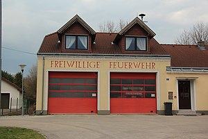
 Schranawand fire department |
||
| Source: STAT : index of places ; BEV : GEONAM ; NÖGIS | ||
Schranawand is a village and a cadastral municipality in the town of Ebreichsdorf in Lower Austria.
The village is located two kilometers northeast of Ebreichsdorf between the state roads L150 and L4042, from which a connecting road branches off into the village. In the east the Fischa flows past the place. On January 1st, 2020 there were 200 inhabitants in Schranawand.
In the Franziszeischen cadastre from 1819 Schranawand is listed as an anger village with numerous homesteads.
history
The first documentary mention was made as early as 1120 as Scranwat when the boundaries of the mother parish Traiskirchen was described. The place was the seat of a small noblewoman with a fortified manor house. In 1320 Ulrich von Schranewaten was allowed to build a church. In 1480 Schranawand is referred to as a market. In the second half of the 15th century the settlement was destroyed in the Hungry War Luff . In 1492 the festivals and the village are described as desolate (ie they are deserted). The repopulation by South Tyroleans took place in 1523 with seven families, in 1525 eighteen families were named. In 1529 in the first Turkish war, the place was completely destroyed and again attacked in 1532. In 1539 17 of 18 houses are inhabited again, in 1571 there were 22 houses. In 1605 the population fell due to attacks by Turks and Tatars. In 1683, during the second Turkish siege, 14 families disappeared, the church and village were probably sacked. In 1694, 20 houses were again inhabited. The place was added to the lordship of Unterwaltersdorf until the basic relief in 1848. In 1848 the place was first cadastral municipality of Unterwaltersdorf and in the first quarter of the 20th century an independent municipality. During the Nazi era he lost his independence and in 1972 was finally incorporated into the market town of Ebreichsdorf.
Schranawand is initially a branch of the Ebreichsdorf parish. From 1721 Schranawand remained at Unterwaltersdorf at the request of the population.
Already in the 16th century there was a mill on the Fischa, which was converted into a screw factory in the 19th century and later into an electrical works. There was the Brauner or Weninger mill on the cold aisle. The volunteer fire brigade was founded in 1893.
literature
- List of places 2001 Lower Austria , Statistics Austria, Vienna 2005, PDF , mentioned on page 68
Individual evidence
- ↑ Statistics Austria: Population on January 1st, 2020 by locality (area status on January 1st, 2020) , ( CSV )
- ^ Franziszeischer Cadastre (around 1820): Schranawand ( on mapire.eu ).
- ↑ History of Schranawand on 4ebreichsdorf.at

