Schwarzmühle (Schwarzatal)
|
Schwarzmühle
Rural community town of Schwarzatal
Coordinates: 50 ° 34 ′ 49 ″ N , 11 ° 4 ′ 35 ″ E
|
||
|---|---|---|
| Height : | 390 m above sea level NN | |
| Residents : | 80 (2012) | |
| Incorporation : | 1923 | |
| Incorporated into: | Meuselbach-Schwarzmühle | |
| Postal code : | 98744 | |
| Area code : | 036705 | |
|
Location of Schwarzmühle in Thuringia |
||
|
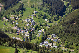
View of the place
|
||
Schwarzmühle is a district of Meuselbach-Schwarzmühle in the rural community Stadt Schwarzatal in the Saalfeld-Rudolstadt district in Thuringia .
location
Schwarzmühle is a very small district. It is located in the Schwarzatal at the inlet of the Meusebach on the right of the Schwarza. The district is located one kilometer northwest of the higher Meuselbach at an altitude of about 390 meters above sea level.
history
Schwarzmühle was first mentioned in a document in 1585. Until 1918 the place belonged to the sovereignty of the principality of Schwarzburg-Sondershausen . In 1923 Meuselbach and Schwarzmühle were already united. In 2012, 80 people lived in the hamlet. On January 1, 2019, Meuselbach-Schwarzmühle merged with two other municipalities to form the rural municipality of the town of Schwarzatal. All further information can be found in the article Meuselbach-Schwarzmühle .
Web links
Individual evidence
- ^ Wolfgang Kahl : First mention of Thuringian towns and villages. A manual. 5th, improved and considerably enlarged edition. Rockstuhl, Bad Langensalza 2010, ISBN 978-3-86777-202-0 , p. 256.
- ↑ Thuringian Law and Ordinance Gazette No. 14/2018 p. 795 ff. , Accessed on January 5, 2019

