Seehorn (Davos)
| Sea horn | ||
|---|---|---|
|
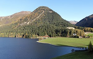
The Seehorn with Lake Davos , from which the Seehorn takes its name. On the right, at the foot of the Seehorn, the Hotel InterContinental. |
||
| height | 2238 m above sea level M. | |
| location | Canton of Graubünden , Switzerland | |
| Mountains | Silvretta | |
| Dominance | 0.614 km → Hüreli | |
| Notch height | 138 m ↓ Chaltboden (saddle between Seehorn and Hüreli ) | |
| Coordinates | 785 546 / 187845 | |
|
|
||
|
Mountain peak of the Seehorn |
||
The Seehorn is 2238 m above sea level. M. high vantage point at the beginning of the Flüela group. Because of the beautiful valley view over the whole landscape and the surrounding mountain ranges, it is often visited from Davos. Due to its exposed location, the Seehorn forms a striking peak. It is conical and drops steeply on all sides with the exception of the east side. The Seehorn is named for its location directly above Lake Davos .
Location and surroundings
The Seehorn belongs to the Flüela Group, a subgroup of the Silvretta . The summit is located entirely within the municipality of Landschaft Davos . The Seehorn closes the Davosertal to the east and pushes itself forward between this and the Flüelatal .
The neighboring summit is the 206 m higher Hüreli . The valley location and most common starting point is Davos.
Climbing garden

To the southwest of the summit, in the rock near the summit, there is a climbing garden at 2060 m to 2238 m . It was built in 1968 and completely renovated in 2007. The climbing garden can be reached on the route over the southwest edge in about 1¼ hours from the Flüelastrasse in Davos Dorf ( 1571 m ) or in about one hour on foot from Bedra ( 1753 m ). Since the climbing garden is on the southern side, it is sunny and offers a beautiful view of Davos, the Flüela valley and the surrounding nature. The climbing garden has 25 climbing routes of difficulty levels 3a to 6a + as well as an abseiling slope . The climbing garden is ideal for families. Fireplace and wood are available at the foot of the wall by the route topo . It is also suitable for practicing multi-pitch routes . A 50 m long climbing rope and 12 quickdraws should be taken as equipment.
Routes to the summit
Over the northeast ridge
- Starting point: Davos Dorf (parking lot by the lake, 1561 m ), Wolfgang ( 1631 m ) or Hst. Davos Laret ( 1522 m )
- Via: Drusatscha, saddle between Seehorn and Hüreli
- Difficulty: B than trail white-red-white marks
- Time required: 2½ hours from Davos, 2¼ hours from Wolfgang or 3 hours from Laret
Over the southwest edge
- Starting point: Davos Dorf (Flüelastrasse (Stilli), 1571 m ) or Bedra ( 1753 m )
- Via: bypass the rock face on the left or right.
- Difficulty: EB
- Time required: 2 hours from Davos, 1¾ hours from Bedra
- Note 1: There is a path, but it is neither signposted nor marked.
- Comment 2: If you bypass the ledge on the right, you will pass the climbing garden.
Over the southern flank
- Starting point: Davos Dorf (Flüelastrasse (Stilli), 1571 m ) or Bedra ( 1753 m )
- Via: rockfall forest, saddle between Seehorn and Hüreli
- Difficulty: B than trail white-red-white marks
- Time required: 2 hours from Davos or 1½ hours from Bedra
panorama
gallery
The Seehorn with the physical-meteorological observatory (left) and the Hotel InterContinental (right).
The Seehorn with Lake Davos as seen from the Dorfberg near the Parsenn ski area .
The Seehorn as seen from the Jakobshorn ski area .
View to the Hüreli .
View towards the Flüela valley and from the Pischahorn (left) to the Flüela Wisshorn (right).
literature
- Bernard Condrau: Club Guide, Bündner Alps, Volume VIII (Silvretta and Samnaun). 3. Edition. Verlag des SAC, 1985, ISBN 3-85902-048-X , pp. 180-181.
- National map of Switzerland, sheet 1197 Davos, 1: 25000, Federal Office of Topography, 2011 edition.
Web links
Individual evidence
- ↑ Climbing garden & climbing walls . Website of the Davos Klosters Mountains . Retrieved September 29, 2014.


