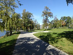
North Harbor Park
| Nordhafenpark Weddinger Alster |
|
|---|---|
| Park in Berlin | |

|
|
| Nordhafenpark on the Weddinger side (east of the Nordhafen ) | |
| Basic data | |
| place | Berlin |
| District | Mitte , Moabit , Wedding |
| Created | 1952-1954 |
| Newly designed | 2008/2009, 2015/2016, 2017 |
| Surrounding streets |
Fennstrasse, Heidestrasse, Sellerstrasse |
| use | |
| User groups | Leisure time , pedestrian traffic , bicycle traffic |
| Park design | Günther Rieck, Willy Alverdes |
The Nordhafenpark ( ), formerly also called Weddinger Alster because of the striking fountain , is a green area that surrounds Berlin's Nordhafen in the Mitte district . The park at the intersection of the districts of Mitte , Moabit and Wedding was designed in the early 1950s and served as a popular local recreation area until the late 1960s .
Due to increasing car traffic and the urban peripheral location in the immediate vicinity of the Berlin Wall , the park was neglected in the following decades and only gradually redesigned with the urban development of the area from 2006 onwards.
history
With the settlement of the "Scheringstadt" (today: Bayer AG site ) in the post-war period , the adjacent open spaces in the area were also upgraded. From 1952/1953 the Weddinger side of the north harbor was designed according to plans of the Weddingen gardening authority Günther Rieck (inauguration on April 24, 1953), on the side of the former Tiergarten district the design followed from 1953/1954 by Willy Alverdes . The port as an industrial place and the river and canal banks were to be converted into green recreational areas. To separate it from the neighboring streets of Fennstraße, Heidestraße and Sellerstraße, dense plantings were made. There was a wooden pergola at the corner of Fennstrasse / Am Nordufer , otherwise the essential structures with terrace , limestone , steps, floor coverings and furniture were still preserved before the redesign.
After its completion, the park was a popular local recreation area for Weddingers and residents of Lehrter Strasse : excursion boats moored, and there was an illuminated fountain in the middle of the northern harbor for about ten years, similar to the Alster fountain in Hamburg . Since the construction of the Nordhafen Bridge in 1970 ( Bundesstrasse 96 ), however, the area has been severely affected by traffic noise. In addition, the Berlin Wall ran south of the fore basin of the Panke, so that the park was on the outskirts of West Berlin . Nevertheless, the West Berlin Senate acquired a section of the park in the Mitte district from the GDR in 1988 in order to enable a circular route around the northern harbor with the reconstruction of the Kiel Bridge , which, however, could only be implemented in 1994.
From 2006, the partial areas of the park could be upgraded as part of compensatory measures as a result of numerous construction activities in the neighboring districts. The promenade on the canal with sunbathing lawn and viewing balcony was designed in connection with the construction of the main train station , while the northern bank of the Pankebecken was redesigned until summer 2009 to compensate for the construction of Ellen-Epstein-Strasse in Moabit and forms today's Sellerpark. In 2015 the pharmaceutical company Bayer bought the street Am Nordhafen in exchange for the redesign of the Nordhafenpark by the beginning of 2016.
Web links
Individual evidence
- ↑ Bernd Schimmler: Small Wedding Chronicle. Retrieved October 7, 2017 .
- ↑ a b c Minutes of the Meeting of Affected Persons on Lehrter Strasse on March 6, 2012 (PDF) In: lehrter-strasse.de. Retrieved October 7, 2017 .
- ↑ Uwe Aulich: Kiel bridge yesterday laid over the shipping canal - the pipes were too long. In: Berliner Zeitung . November 22, 1994. Retrieved October 7, 2017 .
- ↑ Susanne Torka: Sellerpark is being redesigned. In: moabitonline.de. October 22, 2008. Retrieved October 7, 2017 .
- ↑ Redesign of the seller park in Berlin-Mitte. District Office Mitte, October 2, 2008, accessed October 7, 2017 .
- ↑ BAYER am Nordhafen: Take the street, give a park. In: Weddingweiser. February 6, 2015, accessed October 7, 2017 .
- ↑ Nordhafenpark Berlin: Explanations for the implementation planning. (PDF) relais Landschaftsarchitekten, February 28, 2014, accessed on October 7, 2017 (amended on March 16, 2015).
- ↑ Green area at the north port is being redeveloped. In: Berlin Week . February 2, 2015, accessed October 7, 2017 .
- ↑ Start of construction work to redesign the “Am Nordhafen” park. District Office Mitte, January 26, 2015, accessed October 7, 2017 .
Coordinates: 52 ° 32 '15.6 " N , 13 ° 21' 50.1" E