Sikeston
|
|
This article was on the basis of substantive defects quality assurance side of the project USA entered. Help bring the quality of this article to an acceptable level and take part in the discussion ! A closer description on the resolving issues is missing. |
| Sikeston | |
|---|---|
|
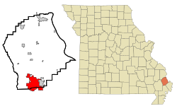
Location in Missouri
|
|
| Basic data | |
| Foundation : | 1860 |
| State : | United States |
| State : | Missouri |
| Counties : |
New Madrid County Scott County |
| Coordinates : | 36 ° 53 ′ N , 89 ° 35 ′ W |
| Time zone : | Central ( UTC − 6 / −5 ) |
| Residents : | 16,992 (as of: 2000) |
| Population density : | 365.4 inhabitants per km 2 |
| Area : | 46.9 km 2 (approx. 18 mi 2 ) of which 46.5 km 2 (approx. 18 mi 2 ) is land |
| Height : | 100 m |
| Postal code : | 63801 |
| Area code : | +1 573 |
| FIPS : | 29-67790 |
| GNIS ID : | 0726435 |
Sikeston is a city of 16,992 inhabitants (2000) in the state of Missouri in the United States . Because it is on the border, the place belongs to Scott County and New Madrid County .
location
It is 92 km west of Paducah , 98 km southwest of Carbondale , 202 km south of St. Louis , and 196 km north of Memphis .
sons and daughters of the town
- Jacqueline Scott (born 1932), actress
- Jean Marie Stine (* 1945), writer and editor
- Kenny Hulshof (* 1958), politician
- Sunset Thomas (* 1972), porn actress
Web links
Commons : Sikeston, Missouri - Collection of pictures, videos, and audio files

