
Siriuskogl
| Siriuskogl | ||
|---|---|---|
 The Siriuskogl on the left under the clouds, above the Katrin , in the foreground the Traun with a railway and pedestrian bridge |
||
| height | 599 m above sea level A. | |
| location | Upper Austria , Austria | |
| Mountains | Dead Mountains | |
| Coordinates | 47 ° 42 '17 " N , 13 ° 37' 4" E | |
|
||
| Type | Inselberg | |
| rock | Limestone ( Hallstatter lime ) | |
| Age of the rock | Nor (approx. 210 million years) | |
| particularities | Stadtberg von Ischl; Siriuskogelwarte from 1885, Einsiedlerstein natural monument | |

The Siriuskogl (also written Siriuskogel , old: Hundskogel ) is 599 m above sea level. A. high city mountain of Bad Ischl in the Salzkammergut in Upper Austria .
Location and landscape

The Siriuskogl is located south of the city center of Ischl , as an island mountain in the middle of the Ischl basin .
It rises on the banks of the Traun , which flows around the mountain in the west and north, about 100 meters above the valley floor. The Sulzbach flows south of the mountain and flows into the Traun. The center of Bad Ischl is north-east of the mountain on the other side of the Traun, upstream then the Kaltenbach district , and directly at the foot of the mountain is the Ischl freight station of the Salzkammergut Railway . To the east of the mountain is the Bad Ischl State Clinic (Salzkammergut Clinic) and a higher federal educational institution. To the south is the Sulzbach district , and to the south-east beyond Salzkammergutstrasse (B145) Reiterndorf .
The Siriuskogl is forested, mostly with mixed forest. The mountain is orographically counted as part of the Dead Mountains .
geology
The mountain is a clod of Hallstatt Limestone from the Norium ( Upper Triassic , approx. 230–210 million years ago). The gray lime is rich in fossils. At the beginning of the 20th century, Ernst Kittl described a new species of zooplankton, small hover shrimp (Mysidacea) , which he assigned to the genus Siriella named after the mountain .
In the Ice Ages, the Siriuskogl was left standing as an island mountain after the Traungletscher had melted. On the mountain is a two-part boulder, the Einsiedlerstein , a boulder . It is an erratic dolomite from the inner Salzkammergut .
History, development and sights

The small mountain was originally called Hundskogel , and was only given a more attractive name when the summer freshness began in the Salzkammergut: Sirius , the "dog star", is the main star of the Big Dog constellation . During this time, the first pleasure complexes were built, facing into the valley, Wi [ e ] rer's parasol and grove , two places furnished in 1825 and 1826 by Ritter von Wierer, the founder of the drinking colonnade in the village, as well as Henrietten's Unrest and Henrietten's Ruhe (or Höhe ) on the Summit, donated in 1825 and 1833 by the wholesaler's wife Henriette Walter,
A circular hiking trail of less difficulty leads around the mountain today. In the extension of Siriuskoglgasse, a driveway leads from the north to the summit, there is another path from the southwest as an extension of the trust path .
To the east of the summit lies the Einsiedlerstein , also called Hexenstein or Adlerstein , on the hiking trail along Siriuskoglgasse . The natural monument is a geotope .
Siriuskogelwarte

At the summit, a wooden observation tower was built on a stone base in 1885, to which initially only one path led up. It was originally called Kaiser-Franz-Josef-Warte , but is now called Siriuskogelwarte . The construction took place at the time when Ischl was in full bloom as an imperial summer residence. The observation tower has been renovated several times, most recently in 1997 and 2006. It is a listed building . In the control room there is a free telescope and a tower book in which hikers can sign.
There is also an inn with a garden. It is owned by the city of Bad Ischl and is leased. Like the observation tower, it was closed in 2005, was refurbished and re-leased in 2006. In February 2008 the city re-tendered the lease. The mountain restaurant was reopened in May 2008. Concerts and other events such as traditional costume balls take place in the restaurant .
A cable car on the western side of the mountain serves to supply the inn , which also transported people until 1992, but is now used exclusively as a transport elevator. It was built in 1948. In 2006, the city of Bad Ischl had the hiking trail that leads uphill from the north widened and paved with gravel in order to facilitate the supply of the Siriuskogl inn. The expansion "as a street" was met with a protest in Bad Ischl, which was demonstrated in July 2007 for a wreath-laying ceremony at Einsiedlerstein.
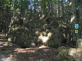
Einsiedlerstein natural monument
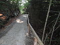
Developed hiking trail to the summit
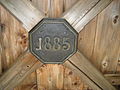
Plaque on the ceiling of the observation tower platform
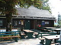
Mountain inn


literature
- Barbara Reiter, Michael Wistuba: Salzburg Salzkammergut . Michael Müller Verlag, Erlangen 2006, ISBN 3-89953-268-6 , p. 142.
Web links
- Website of the control room (siriuskogel.at)
- Description of the circular hiking trail around the Siriuskogl , on Wander.at
proof
- ↑ H. Mostler, P. Parwin: A contribution to the fine stratigraphy of the Hallstatt limestone on Sirius-Kogel (Bad Ischl, Upper Austria). In: Geol.Paläont.Mitt, Innsbruck. 3/7, 1973, pp. 1-47.
- ^ Ernst Kittl: manuscript sheets, unpublished, before 1913; discussed in: Friedrich Trauth: About some crustacean remains from the Alpine-Mediterranean Triassic. In: Annals of the Natural History Museum in Vienna. 32, 1918, pp. 172–192, PDF on ZOBODAT - these species that were first described are now classified differently.
- ^ A b c Anton Johann Groß: Handbook for travelers through the Arch-Duchy of Austria, Styria, Salzburg, Carniola, Carinthia, Tyrol, Illirien, Dalmatia and the Lombard-Venetian Kingdom. Verlag Joseph Lindauer'sche Buchhandlung, Munich 1831, p. 215. ( Digitized, Google, complete view ).
- ↑ a b c d Theodor Hartwig: Pocket book (manual) for travelers through southern Bavaria, Tyrol, Vorarlberg, Salzburg and the Salzkammergut. 3. Edition. Verlag Joseph Lindauer'sche Buchhandlung, Munich 1842, p. 345 (1st edition paperback for travelers through Bavaria's and Tyrol's highlands ; digitized, Google, full view ).
- ↑ a b Emil ∗∗ (anonymous.): Visits to the lake and the Alps in the vicinity of Ischlel's. With geographical vignettes and an overview map of the country above the Enns by F. Raffelsberger. Verlag kkap first typographic art print (in commission by J. Hermann and Son am Graben), Vienna 1842, appendix to the lake and alpine images, 2nd entertainment tariff. P. 142 ff ( digitized version, Google, full view ).
- ^ Peter Wiesinger: Place names and settlement history in the Salzkammergut. In: Yearbook of the Upper Austrian Museum Association. Volume 149, 1, 2004, p. 557 (full article pp. 543–560; pdf, 2.3 MB , landesmuseum.at; there p. 15).
- ^ Condition of the observation tower and inn 2005 and 2006 on the Michael Müller Verlag website ( Memento from September 9, 2012 in the web archive archive.today )
- ↑ Lease of the inn in 2008 ( Memento from March 17, 2008 in the Internet Archive )
- ^ Protest against the "Strasse auf den Siriuskogl" ( memento from August 1st, 2012 in the web archive archive.today ) on the Green Bad Ischl website
- ↑ Report on the laying of the wreath at Einsiedlerstein ( memento from June 7, 2007 in the web archive archive.today ) on the website of the Österreich-Rundschau (with photo)