Snæfellsjökull
| Snæfellsjökull | ||
|---|---|---|
|
Snæfellsjökull |
||
| height | 1446 m | |
| location | Peninsula Snaefellsnes on Iceland | |
| Coordinates | 64 ° 48 '32 " N , 23 ° 46' 16" W | |
|
|
||
| Type | Stratovolcano | |
| Last eruption | around 250 AD (active) | |
| First ascent | July 1, 1753 by Bjarni Pálsson and Eggert Ólafsson | |
|
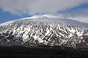
Summit of Snæfellsjökull, May 2003 |
||
The Snæfellsjökull [ 'snaiːfɛlsˌjœkʏtl˳ ] ( Icelandic for "snow mountain glacier ") is a 1446 m high stratovolcano at the western end of the Snæfellsnes peninsula in Iceland .
The mountain was originally called Snæfell or Snjófell , but to distinguish it from two other mountains with this name, the Icelandic name for glacier ( jökull ) is attached to the name. It lies in the area of the municipality of Snæfellsbær .
First ascent
There were some stories from the Middle Ages about brave men who climbed the mountain. Among them is, of course, Bárður Snæfellsás , who is omnipresent in the area - however, he is not very credible as such, as the stories about him are all too suspicious of folk legends.
Later, like many others, the mountain was surrounded by superstition with a halo of mystery and danger. It took the scouts Bjarni Pálsson and Eggert Ólafsson . On July 1, 1753, they stopped on the mountain, armed and A. with a compass, thermometer and a bottle of vinegar, in case the air you breathe becomes a little too thin at this enormous altitude (1446 m). But they succeeded, and, as in the case of Hekla , they are considered to be the first to climb the mountain.
The mountain is now a very popular destination for mountaineers; several groups go up every year.
Height measurements
It has its own reason for determining the height of the volcano: For many centuries, the mountain was considered the highest mountain in Iceland. Back in 1753, Eggert and Bjarni were the first to climb, and their measurements showed the impressive height of 2154 m .
When the mountain was measured again in 1804, it was already much closer to today's measurement of 1,436 m. The exact height of the mountain could only be determined in 1910 by a Danish officer who set it at 1,446 m.
geology
The cap of the stratovolcano is formed by a glacier that fills a small caldera with three small volcanic vents on the edge.
The volcano
The central volcano is around 700,000 years old. Overall, it has erupted around 30 to 40 times since the Ice Age around 10,000 years ago. The last known eruption took place around 1800 years ago. Most of the outbreaks were explosive. The crater with the chimneys appeared at the last eruption. The ashes of this eruption are found scattered across western Iceland. Tertiary rock strata are found in the north and east , while the south and west slopes are covered by post-glacial lavas .
Snæfellsjökull volcanic system
There have also been considerable eruptions in the vicinity of the mountain, during which a large amount of lava flowed out. Most of these lava fields come from the unrest period that followed the last major eruption. There has not been an eruption here since then, but the volcano is still considered active.
The craters in the lowlands of the mountain have produced more basic rock ( basalt ), while acidic or intermediate rock (e.g. rhyolite ) is often found in the layers of the higher craters . Most of the craters are located in Snæfellsjökull National Park such as Saxhóll or Öndverðarneshólar . The Bárðarlaug near Hellnar is a crater from the last interglacial period . The Lóndrangar are the remains of a palagonite mountain that was formed in the sea.
The volcanic system of Snæfellsjökull is around 30 km long and extends from Mælifell in Staðarsveit to Öndverðarnes and perhaps even further out to sea. The central volcano itself is to the west of the system. The famous Búðahraun lava field is part of the Snæfellsjökull system. The lava flowed out of the Búðaklettur crater about 5000 to 8000 years ago .
The glacier
| Snæfellsjökull | |
|---|---|
|
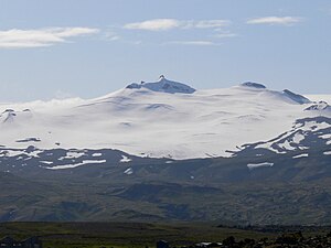
Snaefellsjökull from the north, from Hellissandur (July 2009) |
|
| Type | icecap |
| surface | 10 km² (2008) |
| Altitude range | 1428 m - 637 m (2008) |
| Ice thickness | ⌀ 30 m; Max. 90 m (2003) |
| Coordinates | 64 ° 48 ′ 32 " N , 23 ° 46 ′ 16" W. |
Snæfellsjökull is the only ice cap in Iceland that can be seen from Reykjavík . The glacier extends almost to the highest point of the mountain, which is an ice-free nunatak . The ice reaches furthest down at the northwest outlet glacier , the Blágilsjökull ; there the end of the glacier was in 2008 at an altitude of 637 m . In 2008, an area of 10 km² was determined using laser scanning ( Lidar ). In 2002 an area of 12.5 km² was determined using GPS- based field measurements. The area of the ice cap was still 22 km² in 1910, as can be determined on the basis of maps at that time.
Based on two independently created digital terrain models from 1999 and 2008, an average annual mass balance of −1.25 meters of water equivalent was determined for this period . The loss of mass of Snæfellsjökull thus appears to be somewhat less than that of Eyjafjallajökull , Tindfjallajökull and Torfajökull , all of which are relatively small ice caps. It corresponds roughly to that of Langjökull , but is larger than that of Hofsjökull and Vatnajökull . The geologist Oddur Sigurðsson cites the difference in altitude as the reason for the faster melting of Snæfellsjökull: Hofsjökull and Vatnajökull are approx. 400 to 500 m higher.
The mass loss does not affect all areas of the glacier equally. The areas to the west and east of the summit, where the ice thickness is between 40 and 50 meters, are relatively stable. In places with thin ice, it is to be expected that glacier activity will cease and so-called downwasting will occur there, i.e. the ice will melt on the spot due to cut off ice supplies. Such a process can already be observed in the northeast of Snæfellsjökull, where parts of the glacier lying below the equilibrium line have already been separated from the rest of the glacier.
The Klukkufoss waterfall feeds from the water of Snæfellsjökull .
Snæfellsjökull National Park
The volcano is located in the middle of the Snæfellsjökull National Park named after it and on a clear day can often be seen from Reykjavík , which is about 120 km away as the crow flies. The national park was established in 2001 to protect the natural treasures and the remains of human settlements - such as the remains of winter fishing huts near Dritvík - in the area and to keep them accessible to the general public. The main office is in Hellissandur , an exhibition space since 2004 in Hellnar .
Many riding and hiking trails in the national park area have meanwhile been expanded and marked, and more and more information boards are being put up.
The mountain in literature
It is considered one of the most famous mountains on the island. He owes this not least to the French author Jules Verne , who in his novel Journey to the Center of the Earth creates the entry into the underworld in the crater of Snæfellsjökull. During the filming of the film of the same name, it was shot at the volcano.
With his novel Am Gletscher, the Icelandic national poet Halldór Laxness has set a monument to the mysticism of Icelandic landmarks and especially the glacier.
In many places around Snæfellsjökull one comes across traces of the legendary figure Bárður Snæfellsás . The action of two other Icelandic sagas takes place partly on this mountain: Eyrbyggjasaga and Viglundarsaga .
Esoteric interpretations
In addition, the esoteric side ascribes qualities to the volcano as carriers of special fields of force; the lenticular clouds, which are relatively common here, have repeatedly been misinterpreted as UFOs .
See also
literature
To geology
- Haukur Jóhannesson: Yfirlit um jarðfræði Snæfellsness. In: Einar H. Kristjóansson: Lýsing Snæfellsness frá Löngufjörum að Ólafsvíkurenni. Ferðafélag Íslands, árbók 1982, 151-172.
Fiction
- Jules Verne: Journey to the Center of the Earth. Frankfurt am Main: Fischer-Taschenbuch-Verlag (1979) ISBN 3-596-10001-1 , ISBN 978-3-596-10001-9
- Original edition, e.g. E.g .: Jules Verne, Voyage au center de la Terre , une édition intégrale illustrée de 1919 , sur le site Gallica , la bibliothèque numérique de la Bibliothèque nationale de France. (French)
- Halldór Laxness: On the glacier. Steidl (1994) ISBN 3-88243-304-3 , ISBN 978-3-88243-304-3
- Original edition: Halldór Laxness: Kristnihald undir jökli. Helgafell, Reykjavík 1968 (Icelandic)
Web links
Photos and videos
To the national park
- Off. The National Park website (English)
- National park brochure. (PDF; 355 kB; German)
Scientific treatises
geology
- Snæfellsjökull in the Global Volcanism Program of the Smithsonian Institution (English)
- F. Fuchs et al .: Seismicity revealed in the Snaefellsnes Volcanic Zone, Iceland . (PDF; 36 kB) EGU General Assembly 2012, held April 22-27, 2012 in Vienna, Austria, p. 9808 (abstract, English)
- PG Langdon, KE Barber: New Holocene tephras and a proxy climate record from a blanket mire in northern Skye, Scotland . In: Journal of Quaternary Science , Volume 16, Issue 8, December 2001, pp. 753–759, doi : 10.1002 / jqs.655 (English)
- KT Smith, F. Sigmundsson, E. Sturkell: Palaeoenvironmental reconstruction as a tool in hazard assessment: a case study at Snæfellsjökull. Poster presented at the Natural Science Symposium, University of Iceland, Reykjavík, March 2008. (Risk studies at Snæfellsjökull, Univ. V. Iceland) (English)
- Thomas Find Kokfelt, Kaj Hoernle, Craig Lundstrom, Folkmar Hauff, Christel van den Bogaard: Time-scales for magmatic differentiation at the Snaefellsjökull central volcano, western Iceland: constraints from U-Th-Pa-Ra disequilibria in post-glacial lavas Geochimica et Cosmochimica Acta . geomar.de, 2009, 73 (4), pp. 1120–1144, ISSN 0016-7037 , doi : 10.1016 / j.gca.2008.11.021 (English)
- Haraldur Sigurðsson : Blog page on the geochemistry and petrology of the volcano. Geologist (icelandic)
- E. Martin, ea: Crustal thermal state and origin of silicic magma in Iceland: the case of Torfajökull, Ljósufjöll and Snæfellsjökull volcanoes. ( Memento April 15, 2010 on the Internet Archive ) Contrib Mineral Petrol (2007) 153: 593-605; doi : 10.1007 / s00410-006-0165-5 (PDF file, English)
- Björn S. Hardarson, J. Godfrey Fitton: Increased mantle melting beneath Snaefellsjökull volcano during Late Pleistocene deglaciation . In: Nature , letters to nature, Nature 353, pp. 62–64 (September 5, 1991), doi : 10.1038 / 353062a0 (abstract, English)
- FS Sigurmundsson: Snæfellsjökull, saga og eldvirkni. (PDF; 451 kB) Univ. of Iceland, Nemendarritgerdir, 2008 (Icelandic)
- Olgeir Sigmarsson: Influence of tectonism on the composition of acic and basaltic lava. (PDF; 247 kB) Université Blaise Pascal, Clermont-Ferrand, France, école thématique, Iceland in the central northern Atlantic, 11. – 14. May 2010
- Haraldur Sigurðsson: Jarðskjálftar undir Snæfellsjökli kalla á sjálftamælanet . Blog entry by the geologist from April 17, 2012 (Icelandic)
- Haraldur Sigurðsson: Dýpi skjálfta undir jöklinum . Blog entry, April 19, 2012 (Icelandic)
- Stefan Wastegård et al .: A new mid-Holocene tephra in central Sweden . In: GFF , Vol. 31, iss. 4, 2009, doi : 10.1080 / 11035890903452662
glaciology
- Tómas Jóhannesson: The ice cap Snæfellsjökull is thinning rapidly. IMO, July 6, 2009 (English)
- Tómas Jóhannesson et al .: LIDAR mapping of the Snæfellsjökull icecap, western Iceland. (PDF; 1.6 MB) In: JÖkull. No. 61, 2011 (English)
Individual evidence
- ↑ a b Einar Haukur Kristjánsson: Lýsing Snæfellsness frá Löngufjörum að Ólafsvikurenni . In: Ferðafélag íslands . Árbók 1982, p. 142
- ↑ Einar Haukur Kristjánsson: Lýsing Snæfellsness frá Löngufjörum að Ólafsvikurenni . In: Ferðafélag íslands . Árbók 1982, p. 14
- ↑ Jónas Guðnason: Eldvirkni á á Íslandi Nútíma. Háskóli Íslands. Nemandaritgerð í jarðvísindi . ( Page no longer available , search in web archives ) Info: The link was automatically marked as defective. Please check the link according to the instructions and then remove this notice. (PDF) 2007, p. 5; Retrieved June 4, 2010
- ↑ volcano.si.edu
- ↑ Haukur Jóhannesson: Yfirlit to jarðfræði Snæfellsnes . In: Ferðafélag íslands . Árbók 1982, p. 168 ff.
- ↑ a b c d e f Tómas Jóhannesson et al .: LiDAR mapping of the Snæfellsjökull ice cap, western Iceland. In: JÖkull. , No. 61, 2011, pp. 19–31 (PDF; 1.6 MB)
- ↑ Lenticularis cloud


