Sococha
| Sococha | ||
|---|---|---|
| Basic data | ||
| Residents (state) | 192 pop. (2012 census) | |
| height | 3035 m | |
| Post Code | 05-1501-1000-4003 | |
| Telephone code | (+591) | |
| Coordinates | 22 ° 0 ′ S , 65 ° 29 ′ W | |
|
|
||
| politics | ||
| Department | Potosí | |
| province | Modesto Omiste Province | |
| climate | ||
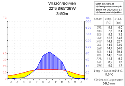
 Climate diagram Villazón |
||
Sococha is a town in the Potosí Department in the South American Andean state of Bolivia .
Location in the vicinity
Sococha is the central place of the canton Sococha in the district ( Bolivian : Municipio ) Villazón in the province Modesto Omiste . The village is located at an altitude of 3035 m in the valley of the Río Sococha, which leads over the Río San Juan del Oro to the Río Pilcomayo . The mountain ridges to the west and east of the village rise up to 3,400 m.
geography
Sococha is located in the southern part of the barren plateau of the Bolivian Altiplano . The climate is cool and dry because of the inland location and there is a typical daytime climate in which the mean temperature fluctuations between day and night are usually significantly greater than the seasonal fluctuations (see Tupiza climate diagram).
The annual average temperature is 11 ° C (see Villazón climate diagram) and fluctuates only slightly between a good 5 ° C in June / July and a good 14 ° C from November to March. The annual precipitation is only about 350 mm, with a strongly pronounced dry season from April to October with monthly precipitation below 10 mm, and a weakly pronounced humidity period from December to February with 70 to 90 mm monthly precipitation.
Transport network
Sococha is located 375 kilometers south of Potosí , the capital of the department of the same name, and about ten kilometers from the border with Argentina .
From Potosí, the Ruta 1 highway, coming from Lake Titicaca , heads south-east and reaches the town of Cuchu Ingenio after 37 kilometers . Here the Ruta 14 branches off , which reaches the town of Tupiza after 224 kilometers via Tumusla , Cotagaita and Hornillos . From there, Ruta 14 continues via Suipacha , Yuruma , Mojo and Cuartos to Matancillas and ends in Villazón on the Argentine border. Two kilometers south of Matancillas at the entrance to Villazón, a dirt road turns east from Ruta 14 , and from here it is another 25 kilometers north-east to Sococha .
population
The population of the village has changed little in the decade between the last two censuses :
| year | Residents | source |
|---|---|---|
| 1992 | 77 | census |
| 2001 | 72 | census |
| 2012 | 192 | census |
Due to the historically grown population distribution, the region has a significant proportion of Quechua population, in the Municipio Villazón 37.8 percent of the population speak the Quechua language.
Individual evidence
- ^ INE - Instituto Nacional de Estadística Bolivia 1992
- ^ INE - Instituto Nacional de Estadística Bolivia 2001
- ↑ INE - Instituto Nacional de Estadística Bolivia 2012 ( Memento of the original from July 22, 2011 in the Internet Archive ) Info: The archive link has been inserted automatically and has not yet been checked. Please check the original and archive link according to the instructions and then remove this notice.
- ↑ INE social data Potosí 2001 (PDF file; 5.2 MB)
Web links
- Municipio Villazón - detailed map and population data (PDF; 628 kB) ( Spanish )
- Municipio Villazón - General Maps No. 51501
- Department Potosí - social data of the municipalities (PDF: 5.23 MB) ( Spanish )
