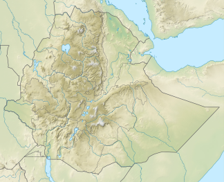
Somali highlands
| Somali highlands | ||
|---|---|---|
| Highest peak | Batu ( 4307 m ) | |
| location | Ethiopia , Somalia | |
|
|
||
| Coordinates | 6 ° 50 ' N , 39 ° 49' E | |
The up to 4307 m high Somali Highlands (also known as the Southern Ethiopian Highlands ) cover the southeast of Ethiopia and the north of Somalia (East Africa ) as high mountains .
location
In the west and northwest, the Somali highlands in Ethiopia drop abruptly into the East African Rift Valley (also called the Abyssinian Rift here ), on the other side of which the Abyssinian highlands join. In the north the high mountains passes this ditch in the ostäthiopische sink over and in Somalia it borders the Gulf of Aden . In the east it extends on the so-called Horn of Africa to the tip of the Somali Peninsula . In the southeast and south it turns into the Somali desert . In the south-west, the mountains merge over the aforementioned rift valley and Lake Turkana into the eastern branch of the East African rift system.
Landscape image
Western Somali Highlands (Southern Ethiopian Highlands)
From the in Ethiopia to the west and northwest adjacent to the Somali-Highland grave breach in which numerous lakes are (including the Abayasee and Tyamosee ) and dominates the thorny savannah, the terrain rises abruptly to Somali highlands down. In this country the central high mountains rises mostly over 3,000 m and finds its greatest elevation in the Mendebo Mountains in Batu ( 4307 m ); the highest of these peaks are often covered in snow for several weeks or months each year.
The rivers Jubba and Shebeli , which flow in a south-east direction to the Indian Ocean , have their source in this highest area of the Somali highlands, in which there is even a tropical rainforest . To the north, too, the highlands in Ethiopia abruptly merge into the above-mentioned rift; therein are again the previously mentioned mandrel savannah , with the swamps , deserts and semi-deserts the east Ethiopian sink (up to 116 m merge). To the east of the Mendebo Mountains already mentioned, there is the Ahmar Mountains , which rises 3381 m in the Gara Muleta . In the south-east and south, the highlands descend over narrow strips of wet and dry savannah over lower regions to the thorn savannah.
In the direction of Somalia - east of the Ahmar Mountains just mentioned - the highlands, the western area of which has been described up to this point, are in part also included in the northern highlands of Abyssinia in Ethiopia and therefore called the Southern Ethiopian Highlands , gently sloping down to the eastern Somali highlands . The clear dividing link - especially from a geological point of view - of the two highlands is the Great African Rift Valley .
Eastern Somali Highlands (Somalia)
In Somalia , the Somali highlands are gradually getting lower towards the east - to the so-called Horn of Africa to the tip of the Somali peninsula . In this northern area of the country, the mountains rise an average of 900 to 2,100 m and find their highest point south of the Gulf of Aden in the Shimbiris ( 2416 m ).
In the north the highlands border on the Gulf of Aden , in the east it ends at Cape Guardafui , where it meets the Indian Ocean , where the island group of Socotra is offshore. In this eastern mountain range is the easternmost tip of the Sahel zone , in which thorn savannahs and semi-deserts determine the landscape. There, the local Somali , who mostly live as nomads , breed cattle ( camels , sheep and goats ). In the southern areas, where there is more rainfall, bananas and sugar cane are grown on elaborately irrigated fields . In the south-east and south, the Somali highlands descend over the Somali desert to the Indic .
climate
While the summit regions of the western Somali highlands are often determined by a tropical and humid climate, the eastern part is dominated almost exclusively by a dry and hot climate; accordingly the vegetation is sparse there. In the west , which is partly very green, the rainy season , which mostly only lets its precipitation fall down in the summit regions (this is also the reason for the Ethiopian droughts ), lasts from June to September. In winter, snow falls in the summit regions.
expansion
The somewhat banana-shaped - seen from a bird's eye view - Somali highlands are in a west-east direction - if you measure the entire distance from Lake Turkana to the eastern tip of the Horn of Africa - approx. 1,600 km long and in north-south direction up to 200 km wide.
mountains
The rather rugged Somali highlands, which are divided into several mountain ranges, are about 900 to a maximum of 4307 m high. The highest peaks are covered with snow for several weeks or months a year , one reason why the waters mentioned below are sometimes supplied with abundant water.
- Mendebo Mountains in the western part of the Somali highlands (Ethiopia)
-
Ahmar Mountains in the central part of the Somali highlands (Ethiopia)
- Gara Muleta ( 3381 m )
- Karkaar chain in the eastern part of the Somali highlands (Somalia)
- Shimbiris ( Shimber Berris ; 2416 m )
Waters
Rivers :
Lakes :
While the Somali highlands are only small lakes are located between the Somali highlands and the highlands of Abyssinia , ie in the African Great grave breach these still waters :
