Sombrero (island)
| sombrero | ||
|---|---|---|
| Historical map of Sombreros with the entries of the mining sites, 1880 | ||
| Waters | Caribbean Sea | |
| Archipelago | Lesser Antilles | |
| Geographical location | 18 ° 35 ′ 21 ″ N , 63 ° 25 ′ 31 ″ W | |
|
|
||
| length | 1.5 km | |
| width | 400 m | |
| surface | 38 ha | |
| Highest elevation | 12 m | |
| Residents | uninhabited | |
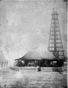
| The old lighthouse and the mine manager's house, around 1880 | ||
Sombrero ( German "Hutinsel" ) is one of the northernmost islands of the Lesser Antilles in the Caribbean and belongs to the British overseas territory of Anguilla .
geography
Sombrero is east of the Virgin Islands and 55 km northwest of Anguilla.
The 1.5 km long and up to 0.4 km wide island has an area of 0.38 km² and consists of almost vegetation-free limestone rock . Originally, the island had the shape of a sombrero from the seaside . Due to the mining of its resources, it now has a flat shape with a height of just 12 m above sea level and various cavities. The surface of the island is rough and karst and the vegetation is sparse.
economy
The island had economic value through its limestone quarries . Sombrerit was mined on the island in the 19th century . This guano- based natural fertilizer was completely mined by US companies from 1856 to 1890. In the 1870s, around 3,000 t of fertilizer containing phosphate are said to have been extracted annually .
history
With the Treaty of Utrecht in 1714, the island came into the hands of the British. In 1814 and 1825, British geologists explored the island and found minable stocks of guano. They reported these results to their government. In 1856 the United States claimed the island's use under the Guano Islands Act . In a very short period of time, around 100,000 t of mineralized bird droppings were extracted as fertilizer in order to make the depleted soils of the southern states fertile again. The United Kingdom intervened late and asked for compensation. British claim to the island was recognized by the United States in 1867 after negotiations.
The island was close to the shipping routes from England to South and Central America in an area that was threatened by cyclones between July and October . As early as 1848 the British Admiralty had been asked in vain for a beacon . In 1859 the Paramatta , a mail ship of the Royal Mail Steam Packet Company, crashed on its maiden voyage as a result of a navigation error on a neighboring reef . The request was then renewed, and in 1868 the lighthouse was put into operation.
After the cessation of guano mining, the operation of the lighthouse was placed under the Board of Trade and later the Department for Transport in 1893 , which transferred it to the Trinity House , which is responsible for the maintenance of all British lighthouses . In 1931 the lighting system was exchanged for a stronger system and the tower was renovated for the first time. The Hurricane Donna damaged the plant in 1960 difficult, so you demolished the tower two years later and replaced by a new building. Today's lighthouse, which is operated fully automatically without a guard, was built in 2001. Its beacon is located at a height of 28 m above sea level and ensures the protection of the Anegada passage . On December 1, 2001, management of the tower was transferred from Trinity House to Anguilla.
In association with Anguilla, whose population decided to assume the status of a British overseas territory, which promised them greater economic stability, the island was politically separated from St. Kitts and Nevis , so that Sombrero became part of a British colony again in 1980.
population
After the miners left, the lighthouse keepers were the only residents on the island. Sombrero has been uninhabited since 2001, only a few fishermen, tourists or biologists visit the island occasionally.
fauna
The island is known for an endemic black rail lizard called Ameiva corvina , which is widespread and easy to spot on the island. A recently discovered dwarf gecko from the genus Sphaerodactylus may also be endemic and has been temporarily referred to as the Sombero dwarf gecko. The iguana-like lizard Anolis gingivinus was also found on the island.
The surrounding waters are used as hunting grounds for hawksbill sea turtles . In addition, the island is home to notable populations of sea birds :
- Masked booby ( Sula dactylatra ): 27 pairs (more than 54 specimens, 4% of the Caribbean population) 2002,
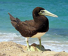
- White-bellied booby ( Sula leucogaster ): 386 pairs (more than 772 specimens, 5% of the Caribbean population) 1999,
- Chinese tern ( Onychoprion anaethetus ): 270 pairs (540 specimens, 4% of the Caribbean population) 1998,
- Noddi ( Anous stolidus ): 700 pairs (1400 specimens, 5% of the Caribbean population) 1998.
Sombrero Island has been designated as an Important Bird Area AI001 by the bird protection organization BirdLife International .
Individual evidence
- ↑ The Island of Sombrero . In: The Illustrated London News . Vol.XLVII, July to December 1865, no. 1323 . George C. Leighton, London 1866, p. 17-18 (English, online ).
- ↑ PSS Paramatta (+1859). In: The Wrecksite. Retrieved November 20, 2017 .
- ^ Russ Rowlett: Lighthouses of Anguilla ( English ) In: The Lighthouse Directory . University of North Carolina at Chapel Hill . Retrieved November 20, 2017.
- ↑ Lords Hansard text for 21 Feb 2005 (50221w06). Anguilla: Sombrero Island Lighthouse. In: UK Parliament website. United Kingdom Parliament , February 21, 2005, accessed November 20, 2017 .
- ^ Johannes Reese: United Kingdom of Great Britain and Northern Ireland. Anguilla. In: States and territories of the world and their language. Archived from the original on December 2, 2008 ; accessed on November 20, 2017 .
- ^ Information Sheet on Ramsar Wetlands (RIS) - Sombrero Island (Anguilla) . In: Mike Pienkowski (Ed.): Review of existing and potential Ramsar sites in UK Overseas Territories and Crown Dependencies . Annex 2: Draft Ramsar Information Sheets for proposed sites identified (as complete as possible in relation to any variations in the actual status of proposed sites), organized by Territory, UK45: Anguilla. United Kingdom Overseas Territories Conservation Forum (UKOTCF), Peterborough April 2005, p. 512 , here: 20. Noteworthy Fauna (English, available online on the UKOTCF website [PDF; 412 kB ; accessed on November 20, 2017]).
- ↑ Important Bird Areas factsheet: Sombrero Island. In: BirdLife Data Zone. BirdLife International , accessed November 20, 2017 .


