Sorgue (Ouvèze)
| Sorgue | ||
|
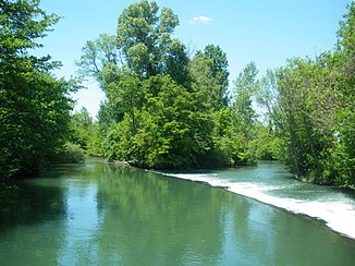
The Sorgue at Entraigues-sur-la-Sorgue |
||
| Data | ||
| Water code | FR : V6150500 | |
| location | France , Provence-Alpes-Cote d'Azur region | |
| River system | Rhône | |
| Drain over | Ouvèze → Rhône → Mediterranean | |
| source |
Karst spring at Fontaine-de-Vaucluse 43 ° 55 ′ 10 ″ N , 5 ° 7 ′ 54 ″ E |
|
| Source height | approx. 100 m | |
| muzzle | across from Bédarrides in the Ouvèze Coordinates: 44 ° 2 ′ 19 ″ N , 4 ° 53 ′ 55 ″ E, 44 ° 2 ′ 19 ″ N , 4 ° 53 ′ 55 ″ E |
|
| Mouth height | approx. 23 m | |
| Height difference | approx. 77 m | |
| Bottom slope | approx. 2.6 ‰ | |
| length | 30 km | |
| Right tributaries | Nesque , Auzon | |
| Small towns | L'Isle-sur-la-Sorgue , Le Thor , Entraigues-sur-la-Sorgue | |
|
L'Isle-sur-la-Sorgue |
||
The Sorgue is a river in the south of France . It rises in a beautiful karst spring with plenty of water at Fontaine-de-Vaucluse and flows into the Ouvèze at Sorgues .
geography
Source de la Sorgue
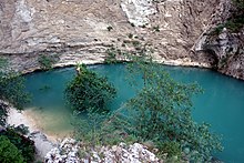
The Source de la Sorgue (Eng. "Source of the Sorgue") or Fontaine de Vaucluse (Eng. "Fountain of the Closed Valley") is the strongest source in France and one of the largest in Europe. It gave the place Fontaine-de-Vaucluse , in which it is located, its name. The mighty karst spring pours an average of 21,800 l / s, but sometimes dries up completely in dry periods. The source of the Sorgue is at the foot of a 230 meter high limestone rock wall. The bluish shimmering spring water rises from a branched cave system with several siphons .
course
The Sorgue first drains in a westerly direction and then swings in to the north. The Sorgue flows through the Vaucluse département and flows after 30 kilometers, opposite Bédarrides , just north of Sorgues , as a left tributary into the Ouvèze . Before L'Isle-sur-la-Sorgue , the Sorgue divides into two arms,
- the Sorgue de Velleron (east) and
- the Sorgue d'Entraigues (west),
which run about 25 kilometers apart and unite again just before the confluence with the Ouvèze.
Places on the river
- Fontaine-de-Vaucluse
- L'Isle-sur-la-Sorgue
- at the Sorgue de Velleron
- at the Sorgue d'Entraigues
Economic use
The water has long been used to power paper , grain and madder mills as well as spinning machines . Immediately behind the source there was a paper mill that is still in operation today as a display facility and can be viewed. River water is diverted through the Canal de Carpentras to generate electricity. The river's water is also used for agricultural purposes and by the recreational industry for kayaking , canoeing and fishing.
Web links
- Fontaine-de-Vaucluse website .
- The poem "La Sorgue" - set to music in Pierre Boulez '"Le soleil des eaux" - comes from the poet René Char , who comes from the Vaucluse département .
Individual evidence
- ↑ a b geoportail.fr (1: 16,000)
- ↑ a b The information on the length of the river is based on the information on the Sorgue from SANDRE (French), accessed on October 6, 2010, rounded to the nearest kilometer.
- ↑ Le milieu karstique p.23 (French) (PDF; 499 kB)


