
St. Paul's (St. Helena)
| St. Paul's | |||
|---|---|---|---|
|
|||
| Coordinates | 15 ° 57 ′ 5 ″ S , 5 ° 43 ′ 21 ″ W | ||

|
|||
| Basic data | |||
| Country | St. Helena, Ascension and Tristan da Cunha | ||
| St. Helena Island | |||
| ISO 3166-2 | SH-HL | ||
| surface | 11.4 km² | ||
| Residents | 843 (2016) | ||
| density | 73.9 Ew. / km² | ||

St. Paul’s is a district and a settlement on St. Helena . The district of St. Paul's has 843 inhabitants (as of 2016) on an area of 11.4 square kilometers .
In addition to the main settlement of the same name, there are two other settlements in the district, Francis Plain and Scotland . With the school Prince Andrew has St. Paul's the only secondary school on the island.
Touristic
St. Paul's is one of the most important tourist districts on the island. Here are among others:
- Plantation House , the seat of the Governor of St. Helena
- St. Paul's Cathedral
- High Knoll Fort
- Prince's Lodge
- Lemon Valley , a historic conservation area
- Jonathan , oldest resident of the island and the oldest living reptile in the world
- Farm Lodge Hotel, a tourist accommodation
Francis Plain has the island's only cricket and soccer field .
gallery

St. Paul's Cathedral

Plantation House
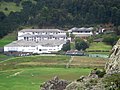
Prince Andrew School
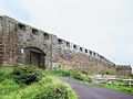
High Knoll Fort
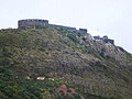
High Knoll Fort
.jpg)
.jpg)
.jpg)
.jpg)
.jpg)
Web links
- In & around St Paul's. Official tourist information. In: Explore St Helena - Visitor Guide. St Helena Tourism, January 2014, p. 21 (PDF; 3.86 MB, English).
- St Pauls - the heartland of St Helena. Information page with photos. In: Saint Helena Island Info: All about St Helena, in the South Atlantic Ocean. John Turner (English).
- St Paul's; St Helena Island. Topographic map 1: 20,000. In: gis-sthelena.gov.sh . Geospatial Information, Mapping and Survey Systems (GIS) St Helena (PDF; 162 kB, English).
Individual evidence
- ↑ Household Population and dwellings by administrative district, 2016. (PDF; 1.18 MB) In: St Helena 2016 Population & Housing Census - Summary Report. St Helena Statistics Office, June 6, 2016, p. 10 , accessed January 12, 2020 .