
Cologne-Mülheim (city district)
 district 9 of Cologne |
|||||||||||||||
|---|---|---|---|---|---|---|---|---|---|---|---|---|---|---|---|
 |
|||||||||||||||
| Coordinates | 50 ° 57 '44 " N , 7 ° 0' 15" E | ||||||||||||||
| surface | 52.20 km² | ||||||||||||||
| Residents | 149,564 (Dec. 31, 2017) | ||||||||||||||
| Population density | 2865 inhabitants / km² | ||||||||||||||
Administration address |
Wiener Platz 2a 51065 Cologne |
||||||||||||||
| Website | Mülheim citizens' office | ||||||||||||||
| structure | |||||||||||||||
| Districts |
Buchforst , Buchheim , Dellbrück , Dünnwald , Flittard , Höhenhaus , Holweide , Mülheim and Stammheim |
||||||||||||||
| politics | |||||||||||||||
| District Mayor | Norbert Fuchs ( SPD ) | ||||||||||||||
| 1. Deputy | Max Derichsweiler ( GREEN ) | ||||||||||||||
| Allocation of seats (district representation) | |||||||||||||||
|
|||||||||||||||
| Source: Cologne District Information - 2015 figures | |||||||||||||||
on May 25, 2014
Mülheim is the 9th district of Cologne . It includes the districts of Buchforst , Buchheim , Dellbrück , Dünnwald , Flittard , Höhenhaus , Holweide , Mülheim and Stammheim .
District 9 bears the name of its most populous district, Mülheim.
At the time of the old postal code system , the districts had the character string '5000 Köln 80'.
location
The city district borders on Leverkusen in the north, Bergisch Gladbach in the east and the Kalk and city center districts in the south . In the west, the Rhine marks the border with the Nippes district .
history
Former Lord Mayor
During the period when the city of Mülheim am Rhein was free of districts, two mayors directed the fortunes of the city. On the one hand, there was Friedrich Wilhelm Steinkopf , who held office from 1876 to 1908. Bernhard Clostermann was Lord Mayor from 1909 until it was incorporated into the city of Cologne in 1914.
Second World War
At noon on October 14, 1944, what was then Mülheim Bridge was destroyed in an air raid by the USAAF .
On October 28, 1944, Royal Air Force bombers launched a heavy air raid on Cologne-Mülheim and other parts of Cologne. The Friedenskirche in Mülheim, the railway line between Mülheim and Köln-Kalk and much more were destroyed.
traffic
The district is accessible with the railway lines Köln Hbf - Köln-Mülheim - Leverkusen - Düsseldorf and Köln Hbf - Köln-Mülheim - Leverkusen-Opladen - Solingen Hbf - Wuppertal , the S-Bahn lines S 6 to Essen via Düsseldorf and Leverkusen and S 11 to Bergisch Gladbach as well as with the trams 3, 4, 13 and 18. Another S-Bahn line via Solingen Hbf to Wuppertal will probably only be implemented in the distant future. At the train station Cologne-Mülheim keep S-Bahn trains, regional rail trains and regional express trains (among which are direct links to Aachen , Bonn , Dusseldorf , Wuppertal and the Ruhr area ). There is a possibility to change to the light rail, which runs here in the tunnel.
The district is connected to the trunk road network by the federal highways 3 , 4 and the federal highways 8 , 51 and 506 .
literature
- State Conservator Rhineland; List of monuments 12.7 Cologne District 9 (Mülheim) , Cologne 1979
photos
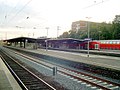
Mülheim station

District town hall Mülheim on Wiener Platz

Mülheim bridge with tour ship, view of the Riehler Ufer


Web links
Footnotes
- ↑ stadt-koeln.de - district representation election 2014 ( memento from June 18, 2015 in the Internet Archive ), accessed on June 18, 2015
- ↑ stadt-koeln.de - stadt-koeln.de - municipal elections 2009 (PDF; 2.6 MB), accessed on June 18, 2015
- ↑ www.bunkerarchaeologie.de
- ↑ Kölner Stadtanzeiger October 24, 2014: Mülheim is in ruins after a bomb attack
Downtown | Rodenkirchen | Lindenthal | Ehrenfeld | Trinkets | Chorweiler | Porz | Lime | Mülheim
Book forest | Buchheim | Dellbrück | Thin forest | Flittard | Höhenhaus | Willow | Mülheim | Stammheim