Stanislaus National Forest
|
Stanislaus National Forest
IUCN Category VI - Protected Area with Sustainable use of Natural Resources |
||
|
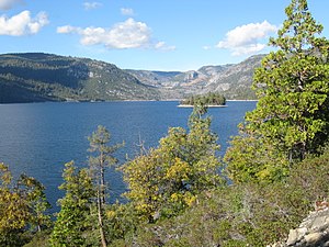
Cherry Lake in the Stanislaus National Forest |
||
| location | California , United States | |
| surface | 3,634.5 km² | |
| Geographical location | 38 ° 9 ′ N , 120 ° 0 ′ W | |
|
|
||
| Sea level | from 450 m to 3350 m | |
| Setup date | February 22, 1897 | |
| administration | US Forest Service | |

The Stanislaus National Forest is a National Forest in California in the United States . It covers an area of 3634.5 km² in the northern Sierra Nevada . The area was established on February 22, 1897, making it one of the oldest National Forests in the United States. It is named after the Stanislaus River , whose headwaters arise in the protected area.
description
The reserve is located at altitudes of approximately 450 m (1,500 feet ) to 3,350 m (11,000 feet), mostly in Tuolumne County and to a lesser extent in Alpine County , Mariposa County, and Calaveras County . The forest is divided into four ranger districts ( Groveland District , Mi-Wok District , Summit District and Calaveras District ).
The area is characterized by the partly snow-capped peaks of the Sierra Nevada, which are surrounded by numerous lakes, over 800 miles of rivers and streams and coniferous forests. In addition to the Stanislaus River, the Clavey River , the longest river in the Sierra Nevada that is not influenced by dams , and the Tuolumne River are noteworthy.
Location and surroundings
The Stanislaus National Forest is located in the northwestern Sierra Nevada. Its entire east side as well as the north and south are surrounded by further protected areas. The Eldorado National Forest is to the north, the Humboldt-Toiyabe National Forest to the northeast and east, and the Yosemite National Park and the Sierra National Forest to the south . Furthermore, wilderness areas , i.e. protected areas of the highest category, which are to be permanently and completely protected from human influences, are wholly or partly in the area of the Stanislaus National Forest. The Emigrant Wilderness in the east of the national forest lies entirely in the Stanislaus National Forest. The Carson-Iceberg Wilderness and the Mokelumne Wilderness in the northeast are only partly located in the state forest area.
traffic
Three well-developed highways run through the area: California State Route 120 in the south, Sonora Pass ( CA 108 ) and Ebbetts Pass ( CA 4 ) in the north of the forest. To the west outside the National Forest, California State Route 49 runs north-south and US Highway 395 runs east .
Flora and fauna
The vegetation changes from meadows and oaks in the lower areas to mixed conifer forests in the higher areas. There are Sequoias , coastal pine , yellow pine , sugar pine , Douglas fir , white fir and Common spruce to find. At higher altitudes, the vegetation becomes subaplinic .
Bald eagles , peregrine falcons and wolverines can also be found in the reserve .
history
Before the arrival of the first Europeans , the area around what is now the National Forest was home to the Miwok Indians, who moved from lower areas to higher altitudes and back with the seasons. During the California gold rush , the area was very busy with prospectors, miners, and other settlers. Several railway lines were built to remove wood from the forest. Traces of it are still visible today.
Web links
Individual evidence
- ↑ a b c USDA Forest Serive : Stanislaus NF Forest Facts . Accessed March 2, 2019 (PDF)
- ↑ a b c d e fs.usda.gov : About the Forest . Accessed March 1, 2019


