
Steinberg (Tosmar)
| Steinberg | ||
|---|---|---|
.jpg) Summit construction with Tosmarhütte |
||
| height | 327.5 m above sea level NHN | |
| location | at Söhre ; District of Hildesheim , Lower Saxony ( Germany ) | |
| Mountains | Hildesheim Forest | |
| Coordinates | 52 ° 4 '49 " N , 9 ° 57' 40" E | |
|
||
| particularities | Remains of the Tosmar tower | |

At 327.5 m, the Steinberg is the highest elevation of Tosmar , a ridge in the Hildesheim Forest . It is located near Söhre in the Hildesheim district in Lower Saxony .
geography
location
The Steinberg rises in the east of the Hildesheim Forest in the Tosmar ridge. It lies between the elevations of Tosmarberg ( 319.9 m ) in the west-northwest and Hammberg ( 313 m ) in the east. Its summit is located 2.3 km south of Söhre and 1.8 km southwest of Röderhof , two districts of the municipality of Diekholzen , 3.7 km northwest of the core town of Bad Salzdetfurth , 3.3 km north-northeast of Petze , a district of Sibbesse , and 3.3 km southeast of the center of Diekholzen.
The Gehlenbach Lamme tributary, which flows eastwards, and the Kalte Beuster, which initially runs westwards, arise south of the elevation as the right source brook of the Beuster .
Natural allocation
The Steinberg belongs in the natural spatial main unit group Weser-Leine-Bergland (No. 37), in the main unit Innerstebergland (379) and in the subunit Hildesheimer Bergland (379.0) to the natural area Hildesheimer Wald (379.01). The landscape falls to the north into the natural area of Marienburger Hügelland (379.03).
Mountain height
The Steinberg is 327.5 m high; its height is also given as 326 m . On it is a 322.6 m high point, which is sometimes mentioned as a mountain height at around 323 m . The elevation has a west-north-west knoll with the 327.5 m high summit and an east-south-east knoll ( 322.5 m ). From the summit, a hill ( 322.5 m ) leads over to the west on the transition area to the Tosmarberg ( 320 m ) .
Protected areas
On the southern slope of the Steinberg there are parts of the Hildesheimer Wald bird sanctuary (VSG no. 3825-401; 12.47 km² ). Except for the transition area to the Hammberg to the east, those of the protected landscape area Röderhofer Teiche and Egenstedter Forst ( CDDA no. 323914; designated 1967; 3.201 km²) extend.
Others
The "Tosmar Tower" was built in 1900 by the Hildesheimer Harz Association on the west-northwest tip of the Steinberg. The wooden observation tower collapsed in a storm night in 1940. Remnants of the foundation are still present. There is currently a wooden cross on this hilltop. The ascent to the summit can be made from the hikers' car park at the Söhrer Forsthaus, 1.2 km north .
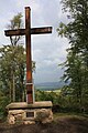
Wooden cross on the Steinberg
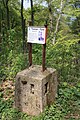
Remnants of the foundations of the former Tosmar Tower with information board


Individual evidence
- ↑ a b c d e Topographic map : Steinberg (DTK 25; heights according to the top contour lines in AK 5 / 2.5), on geolife.de
- ^ Sofie Meisel: Geographical land survey: The natural space units on sheet 86 Hanover. Federal Institute for Regional Studies, Bad Godesberg 1962. → Online map (PDF; 4.0 MB)
- ↑ a b Tosmar Tower information board , photo on commons.wikimedia.org
- ^ Frank Schmidt-Döhl : Between Harz and Heide - mountains, ridges and landscape . Wartberg Verlag, Gudensberg-Gleichen 2010, ISBN 978-3-8313-2319-7
- ↑ Map services of the Federal Agency for Nature Conservation ( information )