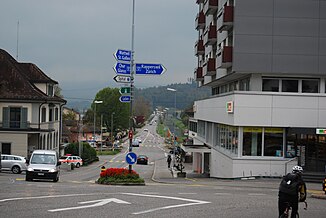
Steinenbach (Limmat)
| Steinenbach | ||
|
Uznach with Steinenbach in the background |
||
| Data | ||
| Water code | CH : 350 | |
| location | Canton of St. Gallen ; Switzerland | |
| River system | Rhine | |
| Drain over | Linth-Hintergraben → Limmat → Aare → Rhine → North Sea | |
| source | in the brook forest near Alp Oberbächen 47 ° 14 ′ 14 ″ N , 9 ° 5 ′ 52 ″ E |
|
| Source height | 1202 m above sea level M. | |
| muzzle | south of Uznach in the Linth-Hintergraben Coordinates: 47 ° 13 ′ 5 ″ N , 8 ° 58 ′ 17 ″ E ; CH1903: 716 105 / 230 799 47 ° 13 '5 " N , 8 ° 58' 17" O |
|
| Mouth height | 406 m above sea level M. | |
| Height difference | 796 m | |
| Bottom slope | 62 ‰ | |
| length | 12.9 km | |
| Catchment area | 35.16 km² | |
| Discharge at the estuary A Eo : 35.16 km² |
MQ Mq |
1.48 m³ / s 42.1 l / (s km²) |
| Left tributaries | Wängibach | |
| Right tributaries | Giegenbach | |
| Communities | Gommiswald , Kaltbrunn , Benken , Uznach | |
The Steinenbach is a river about 13 kilometers long in the west of the Swiss canton of St. Gallen .
course
The Steinenbach rises in the brook forest near Alp Oberbächen a little northwest of the Gubelspitz ( 1346 m above sea level ) in the municipality of Gommiswald and joins several source streams shortly afterwards. After a short run to the southwest, it takes up the Wängibach , which is longer and richer in water , from the left , which flows into the Breitfusstobel . It turns briefly in a north-westerly direction before it flows south-west again and flows through the Steinenbachtobel , which it leaves again at Wilen in Kaltbrunn .
Here it reaches the Linth plain , where it is exclusively straightened and channeled. When Benkner Büchel he makes a bow to the northwest and takes in Starr Mountain in Benken near the castle Bibiton the from the Giegentobel herkommenden Giegenbach on. He now passes the Burgerriet and the Kaltbrunner Riet in the east, which he had previously flowed through. At Uznach it is directed south-west, where it finally flows into the right-hand Linth-Hintergraben, which is fed by several streams and only receives water from the Linth when it rains heavily . Shortly after the confluence of the Steinenbach, it flows parallel to the Linth into Lake Zurich .
Individual evidence
- ↑ a b c d Geoserver of the Swiss Federal Administration ( information )
- ↑ Modeled mean annual discharge. In: Topographical catchment areas of Swiss waters: sub-catchment areas 2 km². Retrieved August 10, 2017 .
