Stendlitz
| Stendlitz | ||
|
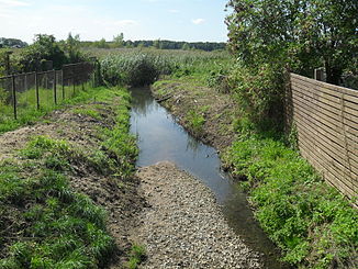
Stendlitz after crossing under the railway line |
||
| Data | ||
| Water code | DE : 581144 | |
| location | Germany , Mecklenburg-Western Pomerania | |
| River system | Havel | |
| Drain over | Floßgraben → Woblitzsee → Havel → Elbe → North Sea | |
| source | in the Moosbruch between Strelitz-Alt u. Carpin 53 ° 20 ′ 58 " N , 13 ° 10 ′ 8" E |
|
| Source height | 70 m | |
| muzzle |
Tiefer Trebbower See , Floßgraben Coordinates: 53 ° 18 ′ 41 ″ N , 13 ° 4 ′ 52 ″ E 53 ° 18 ′ 41 ″ N , 13 ° 4 ′ 52 ″ E |
|
| Mouth height | 57.8 m | |
| Height difference | 12.2 m | |
| Bottom slope | 1.2 ‰ | |
| length | 10 km | |
| Catchment area | 27.7 km² | |
| Right tributaries | Outflow of the Tiefen Zinow, Graben Z008 (upper reaches of the Red Brook) |
|
| Small towns | Neustrelitz | |
The Stendlitz is an approximately ten kilometers (9998 m) long flowing water southeast of Neustrelitz in the Mecklenburg Lake District in Mecklenburg-Western Pomerania .
It flows through the Domjüchsee as its most important inlet and only outlet.
course
The Stendlitz rises four kilometers northeast of the Domjüchsee in the Moosbruch near the watershed between the river systems of the Elbe and the Peene , which runs here over the Dickeberg. It absorbs water from the Tiefen Zinow and then flows through the Jägerpohl , whose water is almost a meter higher today than it was until 1932. From the weir at the outflow of the Domjüchsee, it crosses the north of the Strelitzer Bruch, where it is crossed by drainage ditches with culverts . In the Strelitz-Alt district of Neustrelitz , it is now largely underground. After it has crossed under the Neustrelitz – Berlin railway line, it flows above ground as a straightened brook through the southwestern Strelitz lowland , past the Kalkhorst nature reserve to the east and flows 1.5 kilometers north of Klein Trebbow into the depths of the Trebower Lake , which today belongs to the course of the raft ditch . Its current lower course through the largely silted up flat Tebbower See to the Woblitzsee of the Havel was until 1932 the lower course of the Stendlitz.
literature
Klaus Giese: Tapped lakes for Binnenmühle. In: Nordkurier / Strelitzer Zeitung, series: Strelitz before the 650th anniversary (8) , March 1998.
Web links
Marlies Steffen: A new department store is being built upstairs, and Stendlitz is being diverted below. ( online ( Memento from January 12, 2014 in the Internet Archive )), Neustrelitz, July 17, 2013. In: Nordkurier .
swell
- ↑ http://www.gaia-mv.de/gaia/gaia.php
- ↑ a b c https://www.umweltkarten.mv-regierung.de/script/
- ↑ Klaus Giese: For Binnenmühle lakes tapped. In: Nordkurier / Strelitzer Zeitung, series: Strelitz before the 650th anniversary (8) , March 1998.
- ^ Lutz Gebhardt: Bicycle, hiking and waterway map Wesenberg, Neustrelitz. Havel from Kratzeburg to Röblinsee. 5th updated edition 2010, ISBN 978-386636-090-7 .

