Stephanshausen
|
Stephanshausen
City of Geisenheim
|
|
|---|---|
| Coordinates: 50 ° 2 ′ 6 ″ N , 7 ° 56 ′ 50 ″ E | |
| Height : | 332 m above sea level NHN |
| Area : | 2.88 km² |
| Residents : | 1000 |
| Population density : | 347 inhabitants / km² |
| Incorporation : | January 1, 1977 |
| Postal code : | 65366 |
| Area code : | 06722 |

Stephanshausen is the northernmost district of the city of Geisenheim in the Rheingau-Taunus district in southern Hesse .
geography
Stephanshausen is located in a cleared area of the High Taunus surrounded by forests at an altitude of about 320 to 390 m above sea level. NN on the upper reaches of the Elsterbach flowing south , which flows into the Rhine at Winkel . The district of Stephanshausen belongs entirely to the Rhein-Taunus Nature Park . In contrast to many other communities in the Rheingau , no wine is grown here because of the climatic conditions of the altitude.
history
Discovered ramparts, rubbish pits and burial mounds in the vicinity of the place are on the 5th – 1. Century BC Estimated. The first documented mention of "Stevenshusen" dates from the 13th century AD.
As part of the regional reform in Hesse , the municipality of Stephanshausen was incorporated into the city of Geisenheim on January 1, 1977. A local district was set up for the Stephanshausen district and a local advisory board was elected.
coat of arms
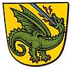
On October 16, 1958, the municipality of Stephanshausen in the Rheingau district was granted a coat of arms with the following blazon by the Hessian Minister of the Interior : In gold, a fire-breathing green dragon pierced by a blue lance .
After the incorporation, the dragon was integrated into the coat of arms of the city of Geisenheim. In Stephanshausen the dragon is still the symbol of the place.
traffic
Stephanshausen is connected to the regional road network by the state road L 3272, which connects to the core town of Geisenheim to the south via Johannisberg and leads to the northwest via Presberg into the Wispertal near Lorch .
Web links
- Stephanshausen district. In: Internet presence. City of Geisenheim
- Stephanshausen in the Rheingau Mountains. Local history, information. In: www.stephanshausen.de. Private website
- Stephanshausen. Local history, information. In: www.rheingau.de. Private website
- Stephanshausen, Rheingau-Taunus-Kreis. Historical local dictionary for Hessen. In: Landesgeschichtliches Informationssystem Hessen (LAGIS).
- Literature about Stephanshausen in the Hessian Bibliography
Individual evidence
- ^ City of Geisenheim: Geisenheim in numbers
- ^ Federal Statistical Office (ed.): Historical municipality directory for the Federal Republic of Germany. Name, border and key number changes in municipalities, counties and administrative districts from May 27, 1970 to December 31, 1982 . W. Kohlhammer GmbH, Stuttgart and Mainz 1983, ISBN 3-17-003263-1 , p. 376 .
- ↑ Approval of a coat of arms of the municipality of Stephanshausen, Rheingaukreis, administrative district Wiesbaden of October 16, 1958 . In: The Hessian Minister of the Interior (ed.): State Gazette for the State of Hesse. 1958 No. 44 , p. 1306 , point 1077 ( online at the information system of the Hessian state parliament [PDF; 3.3 MB ]).


