
Whisper
| Whisper | ||
 Wisper in the locality of Lorch |
||
| Data | ||
| Water code | EN : 256 | |
| location |
Taunus
|
|
| River system | Rhine | |
| Drain over | Rhine → North Sea | |
| source | in Heidenrod , 250 m east of the location of Mappershain 50 ° 10 ′ 14 ″ N , 8 ° 0 ′ 11 ″ E |
|
| Source height | 483 m above sea level NHN | |
| muzzle | in the Rhine at the height of the city center of Lorch Coordinates: 50 ° 2 ′ 34 " N , 7 ° 48 ′ 4" E 50 ° 2 ′ 34 " N , 7 ° 48 ′ 4" E |
|
| Mouth height | 72.7 m above sea level NHN | |
| Height difference | 410.3 m | |
| Bottom slope | 14 ‰ | |
| length | 29.7 km | |
| Catchment area | 208.851 km² | |
| Discharge A Eo : 209 km² at the mouth |
MNQ MQ Mq |
104 l / s 1.271 m³ / s 6.1 l / (s km²) |
| Left tributaries | Fischbach, Gladbach, Ernstbach | |
| Right tributaries | Herzbach, Werkerbach, Tiefenbach | |
| Small towns | Lorch | |
| Communities | Mappershain, Wisper, Geroldstein | |
The Wisper is a 29.7 km long right tributary of the Rhine in the Wispertaunus in Hesse , Germany .
geography
course
The Wisperquelle is located in the western Taunus in the area of Heidenrod , about 250 m south of the exit from the federal highway 260 to Mappershain and just as far east of its locality ( 50 ° 10 ′ 14 ″ N , 8 ° 0 ′ 12 ″ E ). The Wisper flows in a south-westerly direction through a quiet, wooded valley rich in scenic beauty. The valley is very sparsely populated. The only village on both sides of the Wisper is Geroldstein.
From the confluence with the Fischbach to the Rhine, the Wisper is accompanied by the state road 3033, the so-called Wisperstraße. From the confluence of the Gladbach to the bridge on the 3272 state road to Presberg (air line distance 10.5 km), the Wispertal winds very deeply and closely cut 16 km long and rich in tight curves through the Taunus. From then on, the valley widens to Lorch and flows into the Rhine near the city center .
Catchment area
The 208.85 km² catchment area of the Wisper lies in the Taunus and in the Upper Middle Rhine Valley . It is drained through them via the Rhine to the North Sea.
It borders
- in the northwest to the catchment area of the Aar , which drains over the Lahn into the Rhine
- in the southwest of the Walluf and the Kiedricher Bach , both of which flow into the Rhine
- in the south to the catchment areas of the Rhine tributaries Pfingstbach , Elsterbach , Blaubach and Bodentaler Bach
- in the northwest to that of the Betzbach , that of the Volkenbach , that of the Holzbach and that of the Forstbach , which all flow into the Rhine
- and in the north to that of the Mühlbach , which flows into the Lahn
The highest point is the Kalte Herberge at 619.3 m above sea level. NHN in the southwest of the catchment area.
Most of the catchment area is forested.
Natural space
The largest part of the valley system of the Wisper belongs to the natural spatial subunit Wispertaunus, which belongs to the western Hintertaunus . The Wispertaunus has the landscape type of a pure forest landscape, which is deeply divided and only offers space for small village settlements on a few mountain ridges, especially above the northern right side valleys. Here are from west to east: Ransel , Wollmigart , Espenschied , Dickschied , Hilgenroth , Nauroth , Springen and Wisper . Only Presberg is located at a similar altitude above the southern left side valleys . The number of valley settlements is much lower. In the northwest, in the deep and narrow cut of the Tiefenbach, Sauerthal can be found, less because of its geographical advantages and more because of the historical border location in an area of once valuable slate pits . There are also three valley settlements in the southeast: Niedergladbach , Obergladbach and Fischbach . Otherwise there are large contiguous forest areas such as the hinterland forest , which make this natural area particularly worthy of protection. More than a third of the area of the Wispertaunus is designated as a FFH area.
geomorphology
The Wispertal is a pronounced, narrow Sohlenkerbtal to Kerbtal with partly pronounced valley asymmetry . One of the reasons for this are up to 10 meters thick, one-sided loess trails on the eastern slopes, which are almost completely absent on the western slopes. The floodplain of the Wisper is covered, especially in the lower reaches, with differently thick, more or less skeletal layers of clay . It has been proven that they are the result of historical deforestation in the catchment area and are hardly developed any further today.
A meteorological phenomenon is the whisper wind, a cold air flow directed from the Wisper valley towards the Rhine valley, especially in the morning hours.
Flora and fauna
The Wisper is a low, partially even unpolluted water system with quality classes I and I-II. The few now mostly clarified wastewater discharges in the upper reaches of some low-flow tributaries recover quickly due to the well-functioning self-cleaning power of the whispers.
The lower reaches of the Wisper are open to migratory fish . In 2003, salmon that had returned from the sea were reproduced in the Wisper for the first time . Brown trout and sea trout also occur in the Wisper.
The flora is characterized by great climatic differences, little human influence and rich location factors. Many rare plant species, such as orchids, grow in the Wisper area, which is largely designated as an FFH area .
Wispertalsperre
The concept of a Wispertalsperre for water supply was planned in the 1950s and 1960s, but never implemented. For the planning, see the Weiltalsperre .
history
The Wispertal was the northern border region of the Rheingau . To secure the border, several castles were built on both sides of the border in the Middle Ages . In addition to the castles Geroldstein and Haneck (Schwarzenberg) near Geroldstein, down the valley, the Lauksburg near the Laukenmühle and, in addition to the Rheinberg Castle of the Rheingau Rheingrafen, the Blideneck Castle and the Kammerburg , all three on the same ridge at the confluence of the Werkerbach , as well as one Side valley above the village of Sauerthal am Tiefenbach the Sauerburg .
From 1919 until the Ruhr occupation in 1923, a narrow strip in the north of the Wispertal from Lorch via Ransel , Wollmphia , Welterod , Strüth , Zorn and Egenroth to Laufenselden belonged to the Free State of Bottle Neck , a tiny area that was excluded from the Allied occupation of the Rhineland on the right bank of the Rhine and from The rest of the Weimar Republic could only be reached via impassable area.
Attractions
In addition to the winding route popular with motorcyclists, which is now limited to 60 km / h for noise and accident avoidance reasons, the following ruins can be found in the Wisper Valley (from the source to the mouth):

Wisperquelle at Mappershain

Wisper Valley (2010)
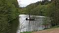
Wispersee (2020)

Cafe Alte Villa in the Wispertal below the Rheinberg castle ruins (2013)

Gasthaus zur Kammerburg, below the castle ruins of the same name (view from 2008; closed in 2017)
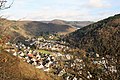
Wispertal near Lorch (2015)


"Gentle tourism" in the Wispertal
A network of hiking trails runs through the Wisper Valley, which is still little known for tourists. The newest hiking trail is called WispertalSteig . In the vicinity of the castles there are several restaurants that offer whisper trout as a local specialty . There are several trout farms, especially on the section between the spacious company premises of the packaging manufacturer Schlaadt and the Alte Villa . The old villa is a former hunting lodge, which got its current heterogeneous shape partly in Art Nouveau and partly in half-timbered houses in the 19th century. Some former mills on the Wisper have been converted into restaurants.
Individual evidence
- ↑ a b Water map service of the Hessian Ministry for the Environment, Climate Protection, Agriculture and Consumer Protection ( information )
- ↑ Hessian Ministry for the Environment, Energy, Agriculture and Consumer Protection: Profile of surface water bodies Profile of surface water bodies ( Memento from February 6, 2013 in the web archive archive.today )
- ↑ Landscape profile ( memento from July 19, 2012 in the web archive archive.today )
- ^ Stolz, C. & J. Grunert (2008): Floodplain sediments of some streams in the Taunus and Westerwald MTs., Western Germany, as evidence of historical land use. In: Zeitschrift für Geomorphologie, 52, pp. 349-373.
- ↑ Status of the reintroduction of the Atlantic salmon (Salmo salar L.) in the Wisper (Hesse) report 2009 (PDF file; 3.98 MB)
Web links
- Water profile and program of measures 256.1 ( Memento from January 1, 2013 in the web archive archive.today ) ( Notes ) → Overview of all Hessian river systems (PDF, 1.7 MB) Wisper
- http://wrrl.hessen.de/viewer.htm (link not available)
- Hessian State Office for Environment and Geology: retention cadastre , river area Wisper - river area code number: 256 (PDF; 32.05 MB) ( Notes )