Stienitzsee
| Stienitzsee | ||
|---|---|---|

|
||
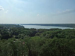
| View from the quail tower over the lake | ||
| GKZ | DE: 58278839 | |
| Geographical location | District of Märkisch-Oderland , Brandenburg | |
| Tributaries | Rüdersdorfer Mühlenfließ (also called Annafließ here), Stranggraben | |
| Drain | Rüdersdorfer Mühlenfließ → Löcknitz → Spree → Havel → Elbe → North Sea | |
| Places on the shore | Hennickendorf | |
| Data | ||
| Coordinates | 52 ° 30'7 " N , 13 ° 49'8" E | |
|
|
||
| Altitude above sea level | 34.4 m above sea level NHN | |
| surface | 2.11 km² | |
| length | 3.18 km | |
| width | 959 m | |
| volume | 14,050,000 m³ | |
| Maximum depth | 14.5 m | |
| Middle deep | 6.6 m | |
| PH value | 8th | |
| Catchment area | 116 km² | |
The Stienitzsee (to differentiate it from the Kleiner Stienitzsee also Großer Stienitzsee ) is located in the municipality of the Rüdersdorf district of Hennickendorf near Berlin . It is classified as a state waterway .
Natural location and development
The Stienitzsee lies in the southern area of the Barnim plateau bordering the Warsaw-Berlin glacial valley . It is part of a glacial channel chain from the Straussee to the Flakensee , which was formed from subglacial drainage channels and is traversed by the Rüdersdorfer Mühlenfließ . The Stranggraben, which drains the Anna Valley, forms a second tributary from the north. Fine, medium and coarse-grained sands with slightly gravelly to gravelly layers prevail in the Rinnental of the Mühlenfließ.
The 3.177 km long and up to 959 m wide lake extends in a north-east-south-west direction and is divided into two basins by a narrow point in the south-west area. The deepest point, at 14.5 meters, is in the northeast area. The Stienitzsee is a lime-rich, stratified lake with a relatively large catchment area of 116 km². The southeastern bank is mostly built up, while the northwestern bank is made up of forests. Hennickendorf belongs to the municipality of Rüdersdorf at the northeastern tip.
Trophic and chemical characteristics
The profile according to the EU Water Framework Directive certifies the Stienitzsee 2017 an ecological status of 4 (= "unsatisfactory status"; environmental target of the WFD is clearly missed) on a five-point scale. The quality components macrophytes / diatoms and phytoplankton also have a value of 4. The chemical status is rated with 3 (= "moderate status"; environmental target of the WFD is just missed). In 2009 the values were still one step better. The LAWA trophy index in 2016 was 2.7. This made the lake weakly eutrophic .
etymology
The name of the lake is derived from the Old Polish “Studenica” (from “studen”; German: “cold”). From the “Studenitz” mentioned in 1231, “Stienitz” emerged.
history
In 1858 the municipal administration lowered the lake level by 2.5 meters so that the clay deposits discovered there could be tapped and transported by ship to the Spree via the southern waterway. In the northern part, this created wet meadows (the so-called rubber meadows ) and an alder forest . An approx. 500 m long boardwalk was laid out directly on the north bank. The clay deposits were used up by 1975.
Directly on the lake is a lido with a sandy beach, sports facilities and restaurants.
See also
Web links
- Excursion tip Großer Stienitzsee. Beach idyll between ruins. from August 24, 2012 in the web portal of the Berliner Zeitung
- Stienitzsee lido
Individual evidence
- ^ Home map of Märkische Schweiz, Berlin glacial valley . 1: 50.000, Falk, Ostfildern 1999. ISBN 978-3-88445-603-3
- ↑ a b c d e Bathing water profile according to Article 6 of Directive 2006/7 / EC and Section 6 of the Ordinance on the Quality and Management of Bathing Water of February 6, 2008 (BbgBadV) . Ministry of Justice and for Europe and Consumer Protection of the State of Brandenburg, updated on January 15, 2018, accessed on August 23, 2018.
- ↑ a b c Profile of Lakes EC Water Framework Directive: Stienitzsee . (PDF; 561 kB), State Office for the Environment Brandenburg , Section W14, as of October 10, 2017.
- ^ Federal and state waterways 2015 in the state of Brandenburg. In: brandenburg.de. Retrieved August 28, 2020 .
- ↑ a b c Brigitte Nixdorf, Mike Hemm, Anja Hoffmann, Peggy Richter: Documentation of the condition and development of the most important lakes in Germany. Part 5: Brandenburg (PDF; 1.9 MB). Environmental research plan of the Federal Ministry for the Environment, Nature Conservation and Nuclear Safety, final report, 2003.
- ^ Albrecht Greule : German book of water names: Etymology of water names and the associated area, settlement and field names . de Gruyter, Berlin 2014, ISBN 978-3-11-033859-1 , p. 515 ( limited preview in Google Book search).
- ↑ 50 years NSG Lange-Damm-Wiesen and Unteres Annatal 2001 , accessed on August 9, 2014.
- ↑ Stienitzsee in the seen.de directory , accessed on June 20, 2014.
