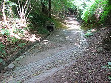
Strakener source system
Today's Strakener spring system is the relic of the historical water supply of the Hoflößnitz . The Straken (from Sorbian strega : "Rinne", "Graben") or Strakengrund is a steep notch valley of the Lößnitz slopes within the Saxon town of Radebeul , from the Wahnsdorf district down to Oberlößnitz . At the same time, Straken is the street name of the Berggasse, which leads through the Straken in a north-south direction. The reason lies in the historical vineyard landscape in Radebeul .
The system consists of the sources on Straken : enclosed or orifice designed descending sources , by Röhrleitungen or flume are connected and pitches and collecting shreds are merged. The resulting trickle flows south towards the Bilz sanatorium . Without drainage into a well house for the water supply or into the sewer system, the Straken spring water would seep into the sand terrace further south towards the Elbe. Like the Fiedlerbach located to the east or the Rietzschke located further to the west, it is one of the so-called lost waters .
The green areas north of the Bilz Sanatorium along the Strakens, in which the flow sources are located, belong to the 115 hectare fauna-flora-habitat area Lößnitzgrund and Lößnitzhang ( Natura 2000 area, EU registration no .: DE4847304, state internal no. : 159); these “west-exposed slope areas on the Bilzturm ” form sub-area 3 (“Oberlößnitz-West”). This sub-area 3 also belongs to the Lößnitz landscape protection area .
Naming
The name, derived from the Sorbian strega (“channel”, “ditch”), of the valley or the mountain ascent through it was documented as strakken or strokken in the Middle Ages . In the 16th century, the form Straken, which is still valid today, appeared . It formed the historical connection route from Alt-Radebeul via Wahnsdorf to Reichenberg .
In the 19th century the path was called Strakenweg ; it began much further south than it is today, where it is part of Eduard-Bilz-Strasse . After the expansion, the name was changed to Strakenstrasse .
Straken water pipe
When exactly the water-collecting tunnels, water-concentrating mouth holes and water-collecting spring heads were created on the mountain is not exactly documented. From 1625 onwards, however, the 1400-meter-long Straken water pipeline ran parallel to Weinbergstraße to the west from the bottom of the collecting shot to the electoral Hoflößnitz; a polygonal water house with a curved hood in the inner courtyard of the winery collected the canal water. Sources from the 17th century call the building the Röhrbrunnen- und Elector Augusti Brunnenhaus . Elector Augusti Brunnenhaus points to Elector August (as a client or as an honor), but could still have been a deep well. Röhrbrunnen- und ... indicates an expansion by spring water brought about by pipelines.
The Strakenleitung initially supplied twelve residents in exchange for water interest. The Hof-Lößnitzer Röhr-Waßer-Ordinance also legally regulated the use from 1744 onwards.
Since it is known that the winery zu Haus Lorenz was the only property on Weinbergstrasse to have its own well, the conclusion can be drawn that the other early modern wineries on Weinbergstrasse were Strakenleitungs users. This is also known from the Meinhold tower house . House Steinbach in Bennostraße below Weinbergstraße was also supplied.
List of sources
The individual flow sources are listed from north to south, i.e. along the valley line falling downhill. West means to the right of the path downhill, east to the left of the path.
literature
- Water supply. In: Frank Andert (Red.): Stadtlexikon Radebeul . Historical manual for the Loessnitz . Published by the Radebeul City Archives. 2nd, slightly changed edition. City archive, Radebeul 2006, ISBN 3-938460-05-9 , p. 213 .
Web links
Individual evidence
- ↑ Lössnitz and Moritzburger Teichlandschaft (= values of our homeland . Volume 22). 1st edition. Akademie Verlag, Berlin 1973, p. 159.
- ↑ Volker Helas (arrangement): City of Radebeul . Ed .: State Office for Monument Preservation Saxony, Large District Town Radebeul (= Monument Topography Federal Republic of Germany . Monuments in Saxony ). SAX-Verlag, Beucha 2007, ISBN 978-3-86729-004-3 (see attached map).
- ↑ according to the information sign of the city of Radebeul im Straken.
- ↑ Ordinance of the Landesdirektion Dresden to determine the area of community importance "Lößnitzgrund and Lößnitzhang" ( memento of the original from August 26, 2014 in the Internet Archive ) Info: The archive link was automatically inserted and not yet checked. Please check the original and archive link according to the instructions and then remove this notice. , accessed June 8, 2012.
- ↑ Overview map of the Habitats Ordinance with the drawing of the area , accessed on June 8, 2012.
- ↑ water supply. In: Frank Andert (Red.): Stadtlexikon Radebeul . Historical manual for the Loessnitz . Published by the Radebeul City Archives. 2nd, slightly changed edition. City archive, Radebeul 2006, ISBN 3-938460-05-9 , p. 213 .
Coordinates: 51 ° 6 ′ 51 ″ N , 13 ° 40 ′ 37 ″ E


