Subarnarekha
|
Subarnarekha Subernarekha, Swarnarekha |
||
|
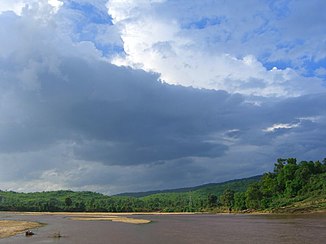
Subarnarekha near Gopiballavpur (Pashim Medinipur District) |
||
| Data | ||
| location | Jharkhand , Odisha , West Bengal | |
| River system | Subarnarekha | |
| source | near the village of Nagri in Ranchi District 23 ° 18'5 " N , 85 ° 11'4" E |
|
| Source height | approx. 610 m | |
| muzzle |
Bay of Bengal Coordinates: 21 ° 33 '16 " N , 87 ° 23' 38" E 21 ° 33 '16 " N , 87 ° 23' 38" E |
|
| Mouth height | 0 m | |
| Height difference | approx. 610 m | |
| Bottom slope | approx. 1.4 ‰ | |
| length | 446 km | |
| Catchment area | 19,277 km² | |
| Right tributaries | Kanchi , Karkari , Kharkai | |
| Reservoirs flowed through | Dhurwa Dam , Getalsud Dam , Chandil Dam | |
| Big cities | Ranchi , Jamshedpur | |
| Small towns | Jaleswar | |
The Subarnarekha (also Subernarekha or Swarnarekha ) is a river in eastern India that flows into the Bay of Bengal .
The Subarnarekha rises at an altitude of about 610 m on the Chhotanagpur plateau near the village of Nagri in the Ranchi district in Jharkhand . It initially flows in an easterly direction past the city of Ranchi . It flows through the reservoirs of the Dhurwa and Getalsud dams . After about 90 km the river turns south. The Kanchi flows into the Subarnarekha on the right. Later the river is dammed by the Chandil dam . The Karkari flows into the reservoir coming from the west. At Jamshedpur , the Kharkai flows into the river from the right. The Subarnarekha continues its course in a southeasterly direction and cuts through the northeastern foothills of the Eastern Ghats . It now runs not far from the border between Odisha and West Bengal . Shortly before the estuary it passes the small town of Jaleswar .
The Subarnarekha has a length of 446 km. It drains an area of 19,277 km². Of these, 13,222 km² are in Jharkhand, 2983 km² in Odisha and 3022 km² in West Bengal.
