Sugar Creek (Driftwood River)
| Sugar Creek | ||
|
Course of Sugar Creek (westernmost headwaters of the East Fork White River) in the catchment area of the Wabash River |
||
| Data | ||
| Water code | US : 444321 | |
| location | Indiana (USA) | |
| River system | Mississippi River | |
| Drain over | Driftwood River → East Fork White River → White River → Wabash → Ohio → Mississippi → Gulf of Mexico | |
| source | in Henry County 39 ° 56 ′ 45 ″ N , 85 ° 30 ′ 30 ″ W. |
|
| Association with |
Big Blue River to Driftwood River Coordinates: 39 ° 20 ′ 47 " N , 85 ° 59 ′ 35" W 39 ° 20 ′ 47 " N , 85 ° 59 ′ 35" W |
|
| Mouth height |
196 m
|
|
| length | approx. 130 km | |
| Catchment area | 1229 km² | |
| Discharge at the Edinburgh A Eo gauge : 1227 km² Location: 2 km above the mouth |
MQ 1944/2016 Mq 1944/2016 |
15 m³ / s 12.2 l / (s km²) |
| Communities | New Palestine | |
|
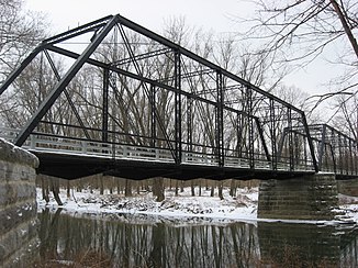
Furnas Mill Bridge |
||
The Sugar Creek (English for " Sugar Creek ") is the right source river of the Driftwood River in the US state of Indiana . The approximately 130 km long river drains an area of 1229 km².
course
Sugar Creek has its source in Henry County west of New Castle . It initially flows 25 km in a westerly direction and then turns south. It runs between Greater Indianapolis in the west and Greenfield in the east. Sugar Creek flows through Madison , Hancock , Shelby, and Johnson counties . The only larger settlement on the river is New Palestine . To the west of Edinburgh , Sugar Creek finally meets the Big Blue River, which runs further east, and joins it to form the Driftwood River.
Individual evidence
- ↑ Sugar Creek in the United States Geological Survey's Geographic Names Information System
- ↑ Driftwood Watershed - 12 Digit HUCs (PDF, 647 KB) USDA - NCRS. Retrieved August 11, 2017.
- ↑ USGS 03362500 SUGAR CREEK NEAR EDINBURGH, IN

