Suining (Sichuan)
Suining ( Chinese 遂宁 市 , Pinyin Suìníng Shì ) is a district-free city in the mountainous southwest China 's Sichuan Province . Suining has an area of 5,326 km² and a population of around 3.29 million (2016). The 2010 census counted 3,252,619 inhabitants. 549,826 people live in the actual urban settlement area of Suining (2010 census).
geography
Suining is located in the middle of the Sichuan Basin on the middle reaches of the Fu Jiang . The terrain is hilly, the area of the city is at an altitude of between 215 and 674 meters. The Fu Jiang (涪江) flows 171 km from north to south through the area of the city, and has a water surface of 14.8 square kilometers. The Zi Jiang (梓 江) flows into the Fu Jiang in the area of the city of Suining from the east and the Qi Jiang (郪 江) from the west . In the west of the city's area, the Qiong Jiang (琼 江) flows parallel to the Fu Jiang. There are seven small and medium-sized reservoirs for energy generation.
economy
Suining is part of the Chengdu-Chongqing Economic Zone and forms a traffic junction between Chengdu and Chongqing . There are 600 kilometers of railway line in the city's area, divided into eight main traffic lines, including the high-speed connection between Chengdu and Chongqing. The construction of an airport is planned in the Anju district . In Suining there are deposits of oil, natural gas, salt and limestone; the "Moxi" gas field in Anju District is the largest single and single-layer natural gas field in Sichuan.
The agricultural area of Suining is 271,300 hectares. The main products produced are grain, oil, fruit (mainly citrus fruits such as oranges, lemons, pomelos; as well as pears, peaches, plums and apples), pork and herbs for traditional Chinese medicine. There are also mulberry and sugar cane plantations ; the greater community Hebian in circles Daying is famous for chrysanthemum tea making facilities . 39% of the area of Suining is covered with forest.
The city has several showcase projects for cleanliness and ecological urban development, and Suining was rated as one of the ten most livable cities in China.
Administrative structure
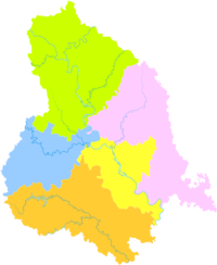
At the district level, Suining is made up of two urban districts, two districts and one urban district:
| map | ||||||
|---|---|---|---|---|---|---|
| Surname | chin. | Pinyin | Residents
(2010) |
surface
(km²) |
Population
density (/ km²) |
|
| Townships | ||||||
| Chuanshan | 船 山区 | Chuanshan Qu | 656 760 | 618 | 1 063 | Seat of the city government |
| Anju | 安居 区 | Ānjū Qū | 639 125 | 1 258 | 508 | |
| Circles | ||||||
| Pengxi | 蓬溪县 | Péngxī Xiàn | 553 239 | 1 251 | 442 | Main town: Chicheng municipality (赤 城镇) |
| Daying | 大 英 县 | Dàyīng Xiàn | 478 896 | 703 | 681 | Main town: Penglai municipality (蓬莱 镇) |
| One district cities | ||||||
| Shehong | 射洪 市 | Shèhóng Shí | 924 531 | 1,496 | 618 | Main town: Taihe municipality (太和镇) |
Suining has had the status of prefecture-level city since 1985. The districts of Chuanshan and Anju were created in 2003, and in 2019 Shehong was converted from a county to an independent city.
The Guangde Temple (广 德 寺, guǎngdé sì) located in the urban area is on the list of monuments of the People's Republic of China .
Web links
- Official Website (Chinese)
Individual evidence
- ^ Official website of Suining: overview. Retrieved November 22, 2019.
- ^ Official website of Suining: Natural Resources. Retrieved November 25, 2019.
- ^ Official website of Suining: History and Culture. Retrieved November 25, 2019.
Coordinates: 30 ° 31 ' N , 105 ° 34' E

