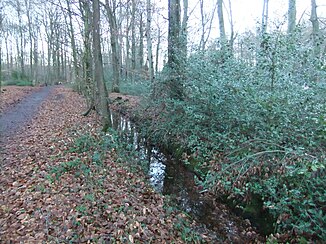
Sunderbach (Trüggelbach)
| Sunderbach | ||
|
Sunderbach in the south of Bielefeld. |
||
| Data | ||
| Water code | DE : 313222 | |
| location | North Rhine-Westphalia , Germany | |
| River system | Ems | |
| Drain over | Trüggelbach → Lutter → Ems → North Sea | |
| source | In the south of Bielefeld-Brackwede 51 ° 58 ′ 38 ″ N , 8 ° 29 ′ 56 ″ E |
|
| Source height | approx. 118 m above sea level NN | |
| muzzle | east of Bielefeld-Ummeln Coordinates: 51 ° 58 ′ 7 ″ N , 8 ° 28 ′ 8 ″ E 51 ° 58 ′ 7 ″ N , 8 ° 28 ′ 8 ″ E |
|
| Mouth height | approx. 94 m above sea level NN | |
| Height difference | approx. 24 m | |
| Bottom slope | approx. 8.6 ‰ | |
| length | 2.8 km | |
| Left tributaries | Grippenbach | |
| Big cities | Bielefeld | |
The Sunderbach is a 2.8 km long orographically right tributary of the Trüggelbach in Bielefeld in North Rhine-Westphalia .
River course
The Sunderbach arises in the south of the Bielefeld district of Brackwede not far from the Südring in a forest and flows off in a south-westerly direction. After crossing under the Hamm – Minden railway line and the new section of the federal motorway 33, the water flows through the park landscape between Brackwede and Ummeln , where the Grippenbach is the only tributary. To the east of the Ummeln settlement focus, the Sunderbach flows into the Trüggelbach on the right. During its entire course, the body of water is exclusively in the area of the Brackweder district, as Ummeln also belongs to this district.
The Sunderbach overcomes a height difference of 24 meters during its course of flow, resulting in an average bed gradient of 8.6 ‰.
Water quality
The water quality of the Sunderbaches is located, according to the water quality report from the year 2008 during its entire flow path in a moderately loaded condition (Grade II).
Individual evidence
- ↑ a b Topographic map 1: 25,000
- ↑ Water directory of the State Office for Nature, Environment and Consumer Protection NRW (PDF; 1.1 MB)
- ↑ Excerpt from the Bielefeld water quality report 2008 (PDF; 2.9 MB)
