Sotla
|
Sotla Sutla |
||
|
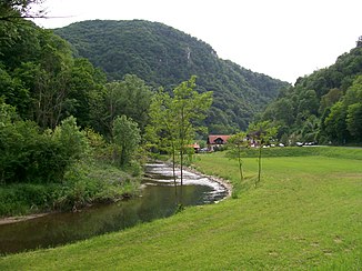
Sotla- / Sutla-Talenge, between the mountain slopes Cesargradska gora and Zelenjak, northwest of Klanjec / Croatia |
||
| Data | ||
| location | Slovenia , Croatia | |
| River system | Danube | |
| Drain over | Save → Danube → Black Sea | |
| source | Log ( Rogatec municipality ), on the southern slopes, below Maceljska gora and Veliki Belinovec | |
| Source height | 718 m. i. J. | |
| muzzle | approx. 2 km south of Rigonce (municipality of Brežice ) in the Sava coordinates: 45 ° 51 ′ 52 ″ N , 15 ° 41 ′ 1 ″ E 45 ° 51 ′ 52 ″ N , 15 ° 41 ′ 1 ″ E |
|
| Mouth height | 135 m. i. J. | |
| Height difference | 583 m | |
| Bottom slope | 6.5 ‰ | |
| length | 90 km | |
| Catchment area | 581 km² | |
The Sotla (German Sottl , Sottla or Sattelbach , Croatian Sutla ) is an approximately 90 km long left tributary of the Sava and forms the Slovenian - Croatian border almost over its entire course, from the origin to the mouth .
geography
course
The Sotla rises in the local area of the widely scattered settlement Log in the municipality of Rogatec / Rohitsch in Slovenia. The source area is on the southern slopes, below the two highest mountain peaks, Maceljska gora ( 718 m. Y. Y.) And Veliki Belinovec ( 717 m. Y. Y. ), Of the wooded border mountains Macelj / Matzel to Croatia.
From its source, the water initially flows in a southerly direction and receives several tributaries. After just 6 km, near the village of Trlično ( 260 m. Yr . ), The brook has covered 420 meters of altitude. From here the river winds, sometimes in larger loops, through a varied hilly landscape in a westerly direction. About 3 km behind the former market town of Rogatec / Rohitsch ( 220 m. In the year ) the water changes its course and flows slowly to the south until it reaches Podčetrtek / Windischlandsberg, the main town in the upper Sotla valley.
From here, the river takes a slight south-easterly direction and runs in more or less extensive meanders through a hilly vineyard landscape, which has been called Sotelsko or Posotelje since tourism began twenty years ago. Below the village of Kunšperk / Königsberg the river passes a 2 km long , narrow gorge formed by the two wooded mountain ridges, Zelenjak ( 507 m. I. Year) and Cesargradska gora ( 509 m. I. Y. ).
After leaving the valley, the Sotla turns its course to the south and flows calmly and slowly through the vineyards of Bizeljsko / Wisell. She is accompanied by scruffy bushes, slender poplars and gnarled willows. About 2 km south of the village of Rigonce / Riegelsdorf, in the municipality of Brežice / Rann, the Sotla flows out at an altitude of 135 m. i. J. in the Save.
Catchment area and backwaters
The catchment area of the Sotla is about 581 square kilometers. Of this, Slovenia has 451 square kilometers and Croatia 130 square kilometers. The most important stream inflows (stream = Slov. Potok) and backwaters from the upper reaches to the mouth are:
- Right tributaries from Slovenia: Žahenberški potok, Draganja, Odenca, Teršnica, Ločnica, Mestinjščica, Olimski potok, Golobinjski potok, Buča, Bistrica, Bizeljski potok, Dramlja, Šica, Negot.
- Left tributaries from Croatia: Brezna, Skoritna.
history
The river is first mentioned on April 15, 1016 in a deed of donation issued by Emperor Heinrich II in Bamberg to Count Wilhelm von Sanngau with the name Zôtle . Emperor Konrad II confirmed this donation to Count Wilhelm on December 30, 1028 in Augsburg , whereby the river is mentioned as Zontlae . Accordingly, the border on the Sottla was created back then. First between the Mark an der Sann , as part of the Holy Roman Empire and the Croatian Kingdom , later with the Kingdom of Hungary .
After the death of Count Wilhelm in 1036, the land on the Sottla fell as heir to his wife Hemma, and through her, the lands were given to the Gurk convent and the Gurk diocese, which was later established there, in 1043 .
literature
- Atlas Slovenije , 109 maps 1:50 000, Ljubljana, 1985.
- Marjan Krušič u. a., Slovenia, travel guide , Ljubljana, 1999.
- Hans Pirchegger, History of Styria, Volume I to 1283 Gotha, 1920.
- Karl Brunner, Duchies and Marches. From the Hungarian storm to the 12th century , Vienna, 1994. ISBN 3-8000-3521-9

