Tanama
|
Tanama Танама |
||
|
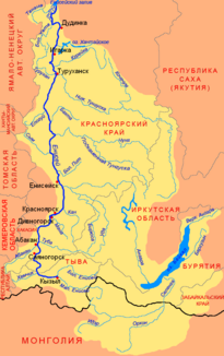
Location of the Tanama (Танама) in the catchment area of the Yenisei |
||
| Data | ||
| Water code | RU : 17010800412116100111576 | |
| location | Yamal-Nenets Autonomous Okrug , Krasnoyarsk Territory ( Russia ) | |
| River system | Yenisei | |
| Drain over | Yenisei → Kara Sea | |
| Headwaters | on the Gydan Peninsula 69 ° 14 ′ 8 ″ N , 81 ° 21 ′ 10 ″ E |
|
| Source height | approx. 70 m | |
| muzzle | in the Yenisei coordinates: 70 ° 27 '22 " N , 82 ° 8' 36" E 70 ° 27 '22 " N , 82 ° 8' 36" E |
|
| Mouth height | 0.5 m | |
| Height difference | approx. 69.5 m | |
| Bottom slope | approx. 0.13 ‰ | |
| length | 521 km | |
| Catchment area | 23,100 km² | |
| Left tributaries | Ngarka-Lybonkatjacha , Jartojacha , Nenerejacha, Pajotajacha | |
| Right tributaries | Bolshaya Pjakojacha, Jara | |
The Tanama ( Russian Танама ) is a 521 km long left tributary of the Yenisei on the Gydan Peninsula in the northeast of the West Siberian lowlands in Russia .
The Tanama flows about 200 km as the crow flies west of Dudinka and 400 km northeast of Novy Urengoy from a small lake in the extreme northeast of the Yamal-Nenets Autonomous Okrug , not far from the border with the Krasnoyarsk region . In a wide arc and strong meandering it first flows around the west to north west, later northeast and southeast direction by the flat tundra landscape beyond the Arctic circle , the northern part of the lower Jenissei-ridge (Nischnejenisseiskaja woswyschennost) , there also Tanamahöhenzug (Tanamskaja woswyschennost) mentioned. This weakly pronounced elevation limits the Gydan peninsula in the south. On the last almost 40 km of its course, the Tanama turns again to the northeast and forms several river arms. The main arm flows almost 200 km northwest of Dudinka into the left large estuary of the Yenisei, which is called Tolstaya Zemlya upstream and Derjabinski Yenisei downstream. Further branches of the Tanama estuary are the Lama, which flows upwards of the Jenisseia for a good 10 km, and the Janadu, which flows down for a good 15 km.
The catchment area of the river covers 23,100 km². The most important tributaries are from the left Ngarka-Lybonkatjacha (length 233 km), Jartojacha (200 km), Nenerejacha (137 km) and Pajotajacha (129 km) and from the right Bolshaya Pjakojacha (130 km) and Jara (277 km). The lower course of the river is under the influence of tides .
For most of its course, the Tanama marks the border between the Yamal-Nenets Autonomous Okrug and the former Taimyr Autonomous Okrug (today Rajon ) of the Krasnoyarsk Territory. It flows through a lake-rich, swampy and very sparsely populated area without villages. About four kilometers south of the origin of the Tanama is the main base of the Severo-Soljoninskoje natural gas field, which has been supplying the city of Norilsk with natural gas via a pipeline since 1973 .
Individual evidence
- ↑ Soviet General Staff Map 1: 200,000. Sheet R-44-XXVII, XXVIII. Edition 1987
- ↑ Soviet General Staff Map 1: 200,000. Sheet R-44-XVII, XVIII. Edition 1991
- ↑ a b c d Tanama in the State Water Register of the Russian Federation (Russian)
- ↑ a b c d Article Tanama in the Great Soviet Encyclopedia (BSE) , 3rd edition 1969–1978 (Russian)
