
Teriberka
| Village
Teriberka
Териберка
|
||||||||||||||||||||||||||||||||||
|
||||||||||||||||||||||||||||||||||
|
||||||||||||||||||||||||||||||||||
.png)
.png)
.svg)

Teriberka ( Russian Териберка ) is a village (selo) in Murmansk Oblast in Russia .
geography
The place is on the northern coast of the Kola peninsula at the mouth of the Teriberka in the bay of the same name in the Barents Sea . It belongs to Rajon Kolski and is located just 90 km in a straight line east-northeast of Oblastverwaltungszentrum Murmansk and the Rajonzentrums Kola . The original village is to the right (east) of the river mouth, the district of Lodeiny, which emerged in the 20th century, is about three kilometers north on the western bank of the bay.
In 1984 a road to Lodeiny was completed (today 49K-051), which branches off about 35 km south of today's 49K-050 Murmansk - Tumanny . A former airfield from the time of the Second World War is located three kilometers southwest of Teriberka on this road . At the end of the 1980s a bridge was built over the river and the old Teriberka was connected to the Russian road network. A lighthouse built in 1896 is located at Cape Teriberka, ten kilometers north of the town on an offshore peninsula .

history
Teriberka was first mentioned as a seasonal Russian fishing settlement in the 16th century. From the beginning of the 17th century it was one of the most important Russian settlements on the coast of the Barents Sea. In 1912 Teriberka became the seat of a Volost in Ujesd Kola in Arkhangelsk Governorate , to which it belonged from 1708 (with an interruption from 1859 to 1883, when the Ujesd was dissolved and merged into Ujesd Kem ).
The district of Lodeiny with a new fishing port was built in the 1930s. He was merged with Lodeiny in 1957. From 1927 to 1960 Teriberka was the seat of the Teriberski rajon (in 1960 all places of the Raion were subordinated to the administration of the city of Severomorsk , the Raion was renamed Severomorsky and dissolved in 1963). From 1938 to 1997 the place had the status of an urban-type settlement . The sharp decline in population from around 1960 was primarily due to the increasing insignificance of inshore fishing.

Teriberka (2013)
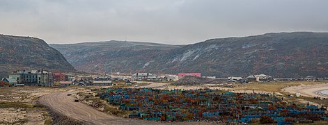
graveyard
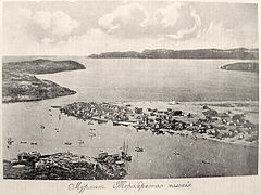
General view around 1900

.jpg)

Population development
| year | Residents |
|---|---|
| 1939 | 2802 |
| 1959 | 4762 |
| 1970 | 3150 |
| 1979 | 2479 |
| 1989 | 2338 |
| 2002 | 1367 |
| 2010 | 957 |
Note: census data
Sons and daughters of the place
- Alexandra Andrejewna Antonowa (1932–2014), Sami writer
Web links
- Official Website (Russian)
- Article Teriberka in the Great Soviet Encyclopedia (BSE) , 3rd edition 1969–1978 (Russian)