
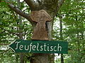
Teufelstisch (Hinterweidenthal)
.jpg)

The Teufelstisch von Hinterweidenthal is a 14 m high mushroom rock reminiscent of a table in the German part of the Wasgau , the southern Palatinate Forest ( Rhineland-Palatinate ). Because of its location in the district of Kaltenbach , the rock formation is also called the Kaltenbach Devil's Table - especially in older literature . It is larger and far better known than the Teufelstisch von Salzwoog , which is only 5 km southwest. In the Palatinate Forest there are more than 20 such mushroom rocks, but they are all much smaller.
The rear Weidenthaler Teufelstisch one of the scenic landmark of the Palatinate ( natural monument number: ND-7340-241) and is also the subject of a local legend (see legend of the Devil's Table ). The rock was depicted several times on postage stamps (see section history ).
geography
The Teufelstisch stands at 284 m above sea level. NHN about 400 m south of the federal highway 10 and west of Hinterweidenthal-Kaltenbach on a ridge up to 312 m high, which extends over more than 2 km from Etschberg ( 321 m ) in the southwest to the glove head ( 324 m ) in the northeast. Between the ridge and the B 10, the Salzbach flows from southwest to northeast , a right tributary of the Lauter , which is called Wieslauter here on its upper reaches . The rock towers above the surrounding forest. At night it is illuminated from the north side so that it can be seen from the B 10.
At the foot of the mountain on which the Teufelstisch stands, there is a parking lot and an excursion restaurant, and the Teufelstisch adventure park was created in its vicinity in 2009 .
geology
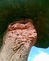
The Teufelstisch is a so-called free - standing tower , the weight of which is estimated at 284 tons. It is a red sandstone rock that is reminiscent of a one-legged table. The softer surface components surrounding it were removed by erosion , while the hard rock core remained.
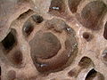
An oversized “table top” about 3 to 4 m thick now lies across an equally massive “table base” about 10 to 11 m high. This foot has a partially crumbly layer. It has bizarre protrusions and tapers to the southwest side like a ship's keel. The plate above is 50 m².
Particularly in the Dahner Felsenland , as the region beginning to the southeast is called, such strikingly shaped rocks are quite common.

Upper part of the table base
Detail of the table base

View through the table base

View through the table base

Cross layering
Washouts


history
As the Palatinate after the Second World War to the French occupation zone belonged to the devil table was on a Rhineland-Palatinate 16 1947 penny displayed postage stamp; In 1948 two different colored stamps for 4 and 16 pfennigs followed. In 2014, the rock was again as a motif on a stamp, this time for 60 cents in the Wildes Deutschland series by Deutsche Post .
Since the 19th century there was a 6 m high pine on the plate of the devil's table, which was a popular photo motif and is also documented on the postage stamp. In 1999 the big tree fell victim to a hailstorm; a younger jaw with a smaller crown is still standing.

16 Pf. Postage stamp (1947)

4 Pf. Postage stamp (1948)

16 Pf. Postage stamp (1948)
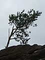
The younger jaw

Devil's table with the younger jaw
information sign


Say about the devil's table
The local legend of the formation of the rock told in a poem by the Palatinate dialect and local poet Johann Martin Jäger (1853–1923), who became known under the pseudonym " Fritz Claus ".
Tourism and climbing
- Teufelstisch adventure park


In autumn 2009, the three-hectare Teufelstisch adventure park was opened in the vicinity of the rock , for which no entrance fee is required. It offers a giant slide embedded in the landscape , a sea of rocks , a labyrinth that leads to a bell tower , a mud station and a cable car . The main part of the construction costs of 1.7 million euros was borne by the state of Rhineland-Palatinate.
From the parking lot at the adventure park, the direct ascent leads to the Teufelstisch in around 20 minutes. The route crosses a marked circular hiking trail that runs around the Etschberg and takes around 2¾ hours. From the crossroads, another short circular hiking trail leads to various rock formations up to 10 m in size on the Glove Head, which is within sight to the northeast of the Teufelstisch, and to a lookout point on Hinterweidenthal. From Salzwoog , a 9.5 km long circular hike over the ridge of the Etschberg has as intermediate destinations first the Teufelsküche , another striking red sandstone rock, and then the Teufelstisch, before reaching the starting point again on the Salzbach upwards.
The climbing area Südpfalz has a large number of climbing rocks ; one of the most famous is the Hinterweidenthaler Teufelstisch. It offers three climbing routes (6+, 7-, 8+) in a particularly appealing atmosphere.
Web links
Individual evidence
- ↑ Rock 11: Kaltenbacher Teufelstisch. Hiking portal Pfalz, accessed on November 1, 2016 .
- ↑ a b c Map service of the landscape information system of the Rhineland-Palatinate nature conservation administration (LANIS map) ( notes )
- ↑ a b Circular hike 15: Over the Etschberg to the Teufelstisch. Wanderportal Pfalz, accessed on February 23, 2012 .
- ↑ a b New adventure park under the Teufelstisch . In: The Rhine Palatinate . Ludwigshafen October 8, 2009.
- ↑ a b c Kaltenbacher Teufelstisch climbing area. (No longer available online.) Klettergebiete-online.de, archived from the original on March 8, 2012 ; Retrieved February 23, 2012 . Info: The archive link was inserted automatically and has not yet been checked. Please check the original and archive link according to the instructions and then remove this notice.
- ↑ Kaltenbacher Teufelstisch. palzpix.de, accessed on November 2, 2016 .
- ↑ Palatinate Forest • Teufelstisch. Deutsche Post , 2014, accessed on June 21, 2015 .
- ↑ Hinterweidenthal: Teufelstisch adventure park. Information and opening times. Hinterweidenthal community, accessed on December 28, 2018 .
- ↑ Kaltenbacher Teufelstisch - Hinterweidenthaler area. German Alpine Club , accessed on August 2, 2017 .
Coordinates: 49 ° 12 ' N , 7 ° 45' E