
Timimoun
|
تيميمون ⵜⵉⵎⵉⵎⵓⵏ Timimoun |
|||
|---|---|---|---|
|
|||
| Coordinates | 29 ° 15 '50 " N , 0 ° 13' 53" E | ||
| Basic data | |||
| Country | Algeria | ||
| province | Timimoun | ||
| ISO 3166-2 | Double room | ||
| surface | 9.8 km² | ||
| Residents | 22,086 (2008) | ||
| density | 2,262.9 Ew. / km² | ||
 City gate of Timimoun
|
|||


Timimoun ( Arabic تيميمون, Central Atlas Tamazight ⵜⵉⵎⵉⵎⵓⵏ ) is a central Algerian oasis town in the Gourara region with around 25,000 inhabitants and the capital of a community consisting of numerous villages with a total of around 35,000 inhabitants. In addition, Timimoun is the capital of the province of the same name .
Location and climate
Timimoun is located on the edge of a salt lake ( sabcha ) at an altitude of about 300 m approx. 1220 km (driving distance) southwest of Algiers in the western Great Erg on the edge of the Tademait plateau . The climate is desert-like and warm to hot; the extremely sparse rain (approx. 15 mm / year), which falls mainly in the winter half-year, collects in the crevices of the mountains and only flows slowly over the clay layers in the subsoil into the lower oases.
The district of Timimoun itself is divided into an old and a newer town. The old part is called ksour ("village" or "castle") after the Berber language for an old Berber fortress and is almost deserted; the newer part was built by the former colonial power France from the 1920s.
History and economy
Timimoun was a caravan site where grain, fabrics and other luxury goods from the north were exchanged for metals and ivory from the south for centuries . In the former dominates more than 30 districts on the via underground channels ( foggaras ) based water-induced swelling of nearby mountains and mainly for Self -powered oases ; only dried dates and pomegranates were negotiated. The available water is directed to the fields via various above-ground channels according to a traditional distribution formula. Tourism has also played a certain role since the 1980s. Timimoun has a national airport.
Attractions
- Timimoun
Particularly in the spring, the palm oases with their small plots, where beans , onions and other vegetables are grown, are particularly worth seeing . The houses in the various villages, built on natural rock, were made of rammed earth or adobe bricks with false ceilings made of palm trunks, small branches and reeds until well into the 20th century ; Since the beginning of the colonial era, they have been successively replaced by buildings with walls made of hollow brick and ceilings made of concrete . In 1990 the "Great Mosque", a building with two minarets and an inner courtyard ( sahn ) , was inaugurated.
- Ksar Draa
In the middle of a sand dune landscape approx. 20 km north of the village lies the so-called Ksar Draa , a round one in the 17th and 18th centuries. Century from quarry stones with clay plaster built storage castle with crenellated wreath . Leaning against the outer wall, there are numerous storage chambers inside. The ksar probably served as a safe resting place for trade caravans .

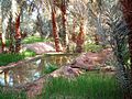
Palm grove and salt lake near Timimoun
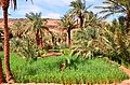
Oasis landscape near Timimoun
Oasis fields with scattered date palms
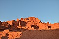
Ruins of the Ksar of Yaghzar


literature
- Hans Imesch: Timimoun. Settlements in the Algerian Sahara. Catalog for the exhibition at the Kunstgewerbemuseum Zurich, 1982.
- Fiction
- Michael Roes : Way to Timimoun . Matthes & Seitz, Berlin 2006, ISBN 978-3-88221-864-0
- Rachid Boudjedra : Timimoun , Roman 1995
Web links
- Timimoun - short video (French)
- Timimoun - photos + information (PDF 228 kB)