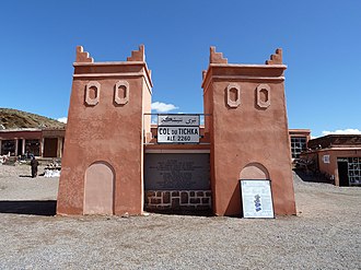
Tizi n'Tichka
| Tizi n'Tichka | |||
|---|---|---|---|
|
Pass height |
|||
| Pass height | 2260 m | ||
| region | Ouarzazate , Drâa-Tafilalet , Morocco | Al Haouz , Marrakech-Safi , Morocco | |
| Mountains | High Atlas | ||
| Map (Ouarzazate) | |||
|
|
|||
| Coordinates | 31 ° 17 ′ 9 ″ N , 7 ° 22 ′ 51 ″ W | ||

The Tizi n'Tichka ( Central Atlas Tamazight ⵜⵉⵣⵉ ⵏ ⵜⵉⵛⴽⴰ Tizi n Ticka ) is a 2260 m (the elevations vary slightly) high mountain pass in the High Atlas in Morocco .
etymology
The two words tizi ( ⵜⵉⵣⵉ ) and tichka ( ⵜⵉⵛⴽⴰ ) come from the Berber language of tachelhit : tizi means "mountain pasture", tichka means something like "dangerous".
location
The pass is the highest point of the N9 road connecting Marrakech and Ouarzazate ; at the same time it forms the border between the regions of Marrakech-Safi and Drâa-Tafilalet . The road forms the shortest and usually the fastest connection between the plain of Marrakech or the coastal cities of the northwest ( Rabat , Casablanca , El Jadida , Safi ) and the vast areas of the Sahara foothills (Ouarzazate, Drâa Valley ) and is therefore also from Drive on trucks and buses.

Navigability
The route, which is easily passable, but winding from around 20 km before and after the top of the pass, is temporarily closed in the winter months (November to March) after heavy or prolonged snowfall. Since the daytime temperatures almost always reach plus degrees during the day, even at altitudes of over 2000 m in southern Morocco, the locks are usually lifted after a few hours, but in rare cases only after days. From an altitude of around 1800 m, the course of the road is marked by red and yellow poles on the sides.
Infrastructure
There are several souvenir shops (rock crystals, fossils, ceramics, Berber jewelry , carpets , blankets, etc.) and cafes on the pass at an altitude of 2260 m . There are souvenir stalls and simple catering options (restaurants, cafes) in front of and behind the top of the pass.
history
The route was already known to the Berber tribes of earlier centuries, who grazed their cattle (sheep, goats) on the rocky, but in places grassy slopes in summer. During the French colonial rule , the old trade route was turned into a dirt road. The route was paved for the first time in the 1960s.
places
The following places are on or near the pass route:


