Great mug
|
Great mug
Community of Schönefeld
Coordinates: 52 ° 19 ′ 59 ″ N , 13 ° 29 ′ 58 ″ E
|
|
|---|---|
| Postal code : | 12529 |
| Area code : | 033762 |
|
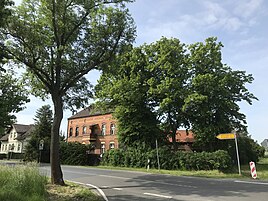
Tollkrug, view to the southwest
|
|
Tollkrug is an inhabited part of the municipality of Waltersdorf in the municipality of Schönefeld in the Dahme-Spreewald district in Brandenburg .
Geographical location
The community part is located south of the center and there south of Berlin Brandenburg Airport . To the east is the further part of the municipality Rotberg , to the south and separated by the federal motorway 10 is the Mittenwald district of Brusendorf and to the west the district of Groß Kienitz of the municipality of Blankenfelde-Mahlow , which is already in the Teltow-Fläming district . The majority of the district is used for agriculture. The area is drained in the west and southwest by the Rotberger flood ditch; this also includes the Brunnenluch lowland , which is located southwest of Tollkrug.
history
Not much is known about the origin of Tollkrug. In the Schmettauschen map series only one intersection is recorded. The name of the place is derived from a jug that was first mentioned in 1801 in the work Statistical-Topographical Description of the entire Mark Brandenburg. Second volume. The Mittelmark and Ukermark containing the Friedrich Wilhelm Bratring. He writes: Tollkrug, Krug belonging to and belonging to Rotzis, where the inhabitants are also listed. The meaning of the name is unclear. According to Schlimpert, it could be associated with the Low German doll = foolish, unreasonable, great. However, he also quotes the opinion of K. Hohmann, who thinks that there was an old customs jug here. The location at the crossroads could actually point to an early highway cash lever. In 1817 it is called Tollkrug (Hungry Wolf), Krug zu Rotzis ... belonging . In 1837 the settlement is called Tollkrug, also known as Hungry Wolf, which consisted of Büdner and day laborer apartments . In 1841 it says: Tollkrug (Hungry Wolf), Krug, belonging to Rotzis ... In 1858 eight people lived there. In 1860 the place consisted of the "Gasthaus Tollkrug, also called Hungry Wolf" with a residential and a farm building. For 1861 only one house with 8 inhabitants is mentioned. In 1871 Tollkrug had 9 residents who lived in a residential building.
In 1927 there were reports of a "House Tollkrug and House Hungry Wolf". Around 1930 there was a gas station in the village.
Attractions
- Berlin Brandenburg Airport
- Replicated milestone at the intersection
Economy, infrastructure and tourism
There is a disposal company for rubble and waste wood in the village.
Tollkrug is at the intersection of two connecting paths. This is Rotberger Strasse, which comes from the west as Chausseestrasse and continues eastwards as well as Landstrasse 75. Coming from the north, it runs as Selchower Strasse and behind the intersection as Tollkrug to Rotberg. There is also a stop of the RVS , which connects to the airport with the 741 line.
In 2014, plans became known that provided a cycle path around the airport site. Under the name Runway 3, there are plans to extend a path that begins in Tollkrug beyond the Jürgen-Schumann-Allee east of the airport. This would lead to a cycle path around the airport which, according to the Märkische Allgemeine newspaper, would be "unique in the world".
literature
- Lieselott Enders and Margot Beck: Historical local dictionary for Brandenburg part IV Teltow. 396 p., Hermann Böhlaus successor, Weimar, 1976
- Gerhard Schlimpert : Brandenburg name book part 3 The place names of the Teltow. 368 p., Hermann Böhlaus successor, Weimar 1972, p. 195.
Individual evidence
- ↑ Service portal of the state administration of the State of Brandenburg: Schönefeld community, accessed on June 25, 2019 .
- ^ Friedrich Wilhelm August Bratring: Statistical-topographical description of the entire Mark Brandenburg. Second volume. Containing the Mittelmark and Ukermark. VIII, 583 p., Berlin, Maurer, 1805 Online at Google Books , p. 524
- ↑ Ortschafts = directory of the government = district of Potsdam according to the latest district division from 1817, with a note of the district to which the place previously belonged, the quality, number of people, confession, ecclesiastical conditions, owner and address, along with an alphabetical register. Berlin, Georg Decker Online at Google Books .
- ↑ Königlich-Prussisches Kammergericht: Topography of the lower courts of the Kurmark Brandenburg and the parts of the state that are struck for them. Compiled from official sources under the supervision of the Court of Appeal. 311 S., Berlin, Ludwig Oehmigke, 1837 Online at Google Books (p. 270)
- ↑ August von Sellentin: Topographical-statistical overview of the government district of Potsdam and the city of Berlin: Compiled from official sources. 292 p., Verlag der Sander'schen Buchhandlung, 1841 Central and State Library Berlin: Link to the digitized version (p. 221)
- ↑ Royal Statistical Bureau: The municipalities and manor districts of the Prussian state and their population. According to the original materials of the general census of December 1, 1871. II. The Province of Brandenburg. Verlag des Königlich Statistischen Bureau, Berlin 1873 Online at Google Books , p. 43 (footnote).
- ↑ Tollkrug near Rotberg , website fotowiesel.de, accessed on June 3, 2019.
- ↑ Klaus Bischoff: Schönefeld is planning a cycle path around the airport . In: Märkische Allgemeine , January 17, 2014, accessed on June 3, 2019.

