Hintermeilingen clay pits
|
Hintermeilingen clay pits
|
||
| location | Hintermeilingen , Waldbrunn (Westerwald) , Limburg-Weilburg district , Hesse | |
| surface | 10.6 ha | |
| WDPA ID | 165920 | |
| FFH area | 154 ha | |
| Geographical location | 50 ° 29 ' N , 8 ° 7' E | |
|
|
||
| Sea level | from 265 m to 335 m | |
| Setup date | September 9, 1985 | |
The clay pits Maria and Barwir II were clay pits near Hintermeilingen in the Westerwald . Today they are a designated nature reserve and part of the FFH area Spitzberg, Gackenberg and Hintermeilingen clay pits .
geography
The clay pits were located about 0.8 km south of Hintermeilingen below the Spitzberg in the Limburg-Weilburg district , Hesse .
The clay pits were located in the transition area between the Oberwesterwald and the Limburg Basin in the Oberwesterwald hill country. The geological underground consists mainly of olivine basalt and quartzites . The clay deposits are about 12 meters thick. They were formed around 52 to 40 million years ago during the Oligocene Period.
history
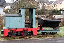
The Maria clay pit started work in 1911. The neighboring Bawir II pit was built around the same time. The prerequisite for the extraction of clay was the connection of Hintermeilingen to the Kerkerbach Railway on October 1, 1905.
The Kerkerbach Railway finally ceased operations in Hintermeilingen on December 20, 1960. The clay pits continued to operate for a few years before they ceased operations. A long discussion began about the subsequent use of the abandoned area. Initially, the village, which had become a resort in 1977, intended to set up a local recreation area with a campsite. In contrast, however, the concept of renaturation prevailed.
In the 1970s, the Naturschutzbund association began with the renaturation of the areas set aside by the operator Gailschen Tonwerke AG, Giessen. The efforts to restore the natural environment were awarded the only gold plaque of the “Federal Industry and Landscape Competition” in 1981.
Nature reserve
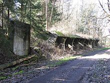
Since September 9, 1985, the area of the former clay pit has been a 10.6 hectare nature reserve. The biotope essentially consists of a tiered area of hedges. This is in front of the high forest. Numerous ponds and pools have been created in this area. The biotope serves as a retreat for numerous birds, amphibians and other animal and plant species.
The 154.36 hectare FFH area includes the clay pit area and the Spitzberg ( 335 m above sea level ) and Gackenberg ( 301.3 m above sea level ) ridge to the south . The high ridge is continuously overgrown with a beech forest. Particularly protected animal species in this area include the crested newt , the great mouse-eared bat and the Bechstein's bat .
Web links
- NABU Waldbrunn e. V .: History 1980 to 2004 , accessed on September 19, 2018
Individual evidence
- ↑ H. Gröschen: How does the sound get to Hintermeilingen. in: Waldbrunner Nachrichten. 26/51/96. P. 18.
- ↑ Regional Council Darmstadt: Ordinance on the nature reserve "Tongruben von Hintermeilingen" of September 9, 1985 in State Gazette for the State of Hesse No. 38/1985 p. 1748
- ↑ 5514-302 Spitzberg, Gackenberg and clay pits of Hintermeilingen. (FFH area) Profiles of the Natura 2000 areas. Published by the Federal Agency for Nature Conservation . Retrieved November 17, 2017.


