Toulourenc
| Toulourenc | ||
|
Catchment area of the river |
||
| Data | ||
| Water code | FR : V6030500 | |
| location | France , Auvergne-Rhône-Alpes and Provence-Alpes-Cote d'Azur regions | |
| River system | Rhône | |
| Drain over | Ouvèze → Rhône → Mediterranean | |
| source | in the municipality of Aulan 44 ° 14 ′ 12 ″ N , 5 ° 24 ′ 30 ″ E |
|
| Source height | approx. 960 m | |
| muzzle | on the municipal boundary of Mollans-sur-Ouvèze and Entrechaux in the Ouvèze Coordinates: 44 ° 14 ′ 17 ″ N , 5 ° 9 ′ 7 ″ E, 44 ° 14 ′ 17 ″ N , 5 ° 9 ′ 7 ″ E |
|
| Mouth height | approx. 240 m | |
| Height difference | approx. 720 m | |
| Bottom slope | approx. 18 ‰ | |
| length | 39 km | |
| Catchment area | 170 km² | |
|
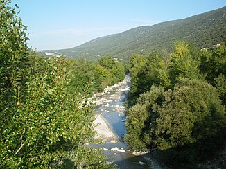
The river at Saint-Léger-du-Ventoux |
||
The Toulourenc is a river in France in the Auvergne-Rhône-Alpes and Provence-Alpes-Côte d'Azur regions . It rises in the municipality of Aulan , initially drains in a generally southerly direction, turns at Montbrun-les-Bains from west to northwest, then runs on the north side of Mont Ventoux and after a total of 39 kilometers it flows into the municipal boundary of Mollans-sur-Ouvèze and Entrechaux as a left tributary into the Ouvèze . On its way, the Toulourenc crosses the Drôme and Vaucluse departments . In its lower reaches the river forms the border between the affected departments and regions.
Places on the river
Web links
Commons : Toulourenc - collection of images, videos and audio files
Remarks
- ↑ a b geoportail.fr (1: 16,000)
- ↑ a b c The information on the length of the river is based on the information on the Toulourenc from SANDRE (French), accessed on July 30, 2011, rounded to the nearest kilometer.

