
Tronador (volcano)
| Tronador | ||
|---|---|---|
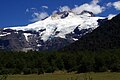
 View of the Tronador volcano from Lake Mascardi , Argentina |
||
| height | 3491 m | |
| location | Río Negro , Argentina - Región de los Lagos , Chile | |
| Mountains | To the | |
| Notch height | 2642 m | |
| Coordinates | 41 ° 9 ′ 39 ″ S , 71 ° 53 ′ 15 ″ W | |
|
||
| Type | Stratovolcano | |
| First ascent | 1934 by Hermann Claussen | |

Tronador is an extinct stratovolcano in the southern Andes , on the border between Argentina and Chile , near the Argentine city of Bariloche . The mountain was named Tronador ( Spanish for thunder ) by locals because of the sound of falling seracs . With its height of 3470 m, it towers over the nearby other mountains of the Andes by more than 1000 m, making it a popular mountaineering destination. Located in two national parks, Nahuel Huapi in Argentina and Vicente Pérez Rosales in Chile, it is home to a total of eight glaciers that are currently receding due to climate change .
Geography and geology
The Tronador is located in the Humid Andes , a zone of high rainfall, both in the form of snow and rain. The humid temperate climate of the southern Andes allows the formation of several glaciers thanks to the high rate of accumulation. Most of the precipitation is formed by western fronts from the Pacific . Located in the middle part of the Andes massif at a latitude of 41 ° S, the Tronador is part of an alpine landscape of fjords , glacial lakes and trough valleys . The landscape was formed during the Cenozoic Ice Age when the whole area was covered by the Patagonian Ice Sheet . The volcano grew in the cold and warm periods of the Pleistocene , but almost died out during the late middle Pleistocene 300,000 years ago, due to a shift in the active front of the southern volcanic zone to which it belongs. Since then, glaciers and other erosive processes have shaped the mountain without further deposition of lava and pyroclastic sediments . Like the nearby Lanín Volkan , the Tronador is mainly made of basalt .
glacier


Typical of the Tronador are its numerous glaciers that cover parts of its flanks. Up to eight glaciers were listed: Alerce, Ventisquero Negro, Casa Pangue, Castaño Overa, Río Blanco, Frías, Peulla and Manso. Like most glaciers in the southern Andes, those of the Tronador have also been shrinking in recent decades. The Casa Pangue Glacier on the northwest side of the Tronador experienced a thinning between 1961 and 1998, with an increased rate between 1981 and 1998 of 52 ma −1 . The shrinking and thinning are due to a decrease in precipitation and a warming of the upper troposphere in the last few decades.
The Alerce Glacier, on the Argentine side, can be visited from Refugio Otto Meiling , a mountain hut between it and the Castaño Overo Glacier. Castaño Overa, also on the Argentine side, is smaller and relatively easy to reach by hiking from Pampa Linda. Guided trekking tours allow visitors to cross the Castaño Overa or hike to the top of the Tronador.
Ventisquero Negro ("black snowdrift" in Spanish) is a rather unusual glacier at the foot of the Tronador in the Nahuel Huapi National Park . The unusual dark brown color of the glacier comes from the soil and sediments that the glacier took up in its formation zone, which is fed by the Río Manso glacier. This is a few hundred meters higher on the mountain. Brown icebergs calve from the glacier and float on a small lake until they melt.
summit
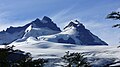
According to the Aoneker map, these are the named peaks of the Tronador: Anon or Internacional (3484 m), Argentino (3187), Chileno (3262), Torre Ilse (2585). Ridge: Filo Sur (3054), Filo Blanco (3146), Filo La Vieja (2715), Filo Lamotte (2340).
Mountaineering and tourism
The Tronador was climbed for the first time after several attempts by Hermann Claussen alone on January 29, 1934. The refuge Refugio Otto Meiling is the destination of popular day hikes. It is named after a climber who made dozens of climbs and led people up the mountain for years. The hut is about 1200 m vertically above Pampa Linda, which is at the foot of the mountain.
In most summers the Internationale or Anon summit (the highest of the 3 summits) can be climbed. However, in January / February 2008 the danger of falling rocks increased to a dangerous level due to the unusually hot summer. The Argentine side threatens to become inaccessible in the future as increasingly warm weather in the region destabilizes the glaciers.

See also
gallery
View from Pampas Linda.
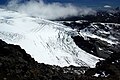
Alerce Glacier, one of Tronador's 8 glaciers.


Web links
- Tronador in the Global Volcanism Program of the Smithsonian Institution (English)
Individual evidence
- ^ "Cerro Tronador, Argentina / Chile" . Peakbagger.com. (Note: Some sources, e.g. Peaklist.org, give a slightly lower altitude of 3470 m.) Retrieved May 12, 2013.
- ^ "Argentina and Chile, Central Ultra Prominences" . Peaklist.org. Retrieved May 12, 2013.
- ↑ a b Bown, Francisca. 2004. Cambios climáticos en la Región de Los Lagos y respuestas recientes del Glaciar Casa Pangue (41º08'S). Tesis para optar al grado de Magíster en Geografía. Universidad de Chile .
- ↑ Mauricio Mella, Jorge Muñoz, Mario Vergara, Erik Klohn, Lang Farmer, Charles R. Stern Petrogenesis of the Pleistocene Tronador Volcanic Group, Andean Southern Volcanic Zone , Revista Geológica de Chile