Tscherek
|
Tscherek Че́рек, Шэрэдж |
||
| Data | ||
| Water code | RU : 07020000612108200004926 | |
| location | Kabardino-Balkaria ( Russia ) | |
| River system | Terek | |
| Drain over | Baksan → Malka → Terek → Caspian Sea | |
| Confluence of |
Tscherek-Balkarski and Tscherek-Chulamski 43 ° 16 '56 " N , 43 ° 33' 36" O |
|
| Source height | 714 m | |
| muzzle | in Baksan coordinates: 43 ° 42 ′ 1 " N , 44 ° 3 ′ 2" E 43 ° 42 ′ 1 " N , 44 ° 3 ′ 2" E |
|
| Mouth height | 190 m | |
| Height difference | 524 m | |
| Bottom slope | 6.9 ‰ | |
| length | 76 km | |
| Catchment area | 3070 km² | |
| Drain |
MQ |
39.5 m³ / s |
| Medium-sized cities | Maiski | |
| Small towns | Kaschchatau | |
|
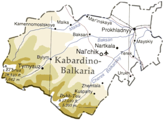
Cherek river course (shown as Tscherek-Balkarsky) |
||
The Tscherek ( Russian Черек ; Kabardian Шэрэдж) is a right tributary of the Baksan river system of the Terek in the Russian Republic of Kabardino-Balkaria in the North Caucasus .
The Tscherek arises at the confluence of the Tscherek-Balkarski and Tscherek-Chulamski rivers , which are fed by the glaciers on the northern flank of the Greater Caucasus . It flows mainly in a north-easterly direction and finally flows into the Baksan. Cities and settlements along the river are: Kaschchatau , Saragisch , Auschiger , Psygansu , Stary Tscherek , Nizhny Tscherek , Psynabo and Maiski .
The Tscherek has a length of 76 km. It drains an area of 3070 km². The river is mainly fed by meltwater from glaciers and snowmelt. Occasional floods occur in summer. The mean discharge is 39.5 m³ / s.
The river has been used for rafting , at least in the past .

