Tschir
|
Tschir Чир |
||
|
|
||
| Data | ||
| Water code | RU : 05010300812107000009603 | |
| location | Rostov Oblast , Volgograd Oblast ( Russia ) | |
| River system | Don | |
| Drain over | Don → Black Sea | |
| source | around 10 km west of Verkachchirsky 49 ° 23 ′ 43 ″ N , 41 ° 9 ′ 8 ″ E |
|
| muzzle | at Nischni Chir in the Tsimlyansk Reservoir pent Don coordinates: 48 ° 29 '40 " N , 43 ° 2' 46" O 48 ° 29 '40 " N , 43 ° 2' 46" O
|
|
| length | 317 km | |
| Catchment area | 9580 km² | |
| Discharge at the Oblivskaya gauge |
NNQ (December 1935) MQ HHQ (April 1956) |
410 l / s 12.5 m³ / s 349 m³ / s |
| Left tributaries | Chernaya , Kriwaja , Zuzkan , Kurtlak , Masha , Berjosowaja , Dobraja | |
| Reservoirs flowed through | Zimljansk reservoir | |
| Small towns | Bokovskaya , Oblivskaya, Surovikino | |
|
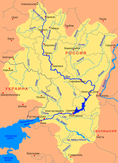
Location of the Tschir (Чир) in the catchment area of the Don |
||
The Tschir ( Russian Чир ) is a 317 km long right tributary of the Don in the European part of Russia .
River course
The Tschir rises on the Danube ridge in the north of the Rostov Oblast , in a sparsely populated, relatively dry landscape. First of all, it flows from there in an easterly and south-easterly direction through the agricultural north of the oblast. Shortly after passing Bokovskaya , the river approaches the border of Volgograd Oblast within a few hundred meters. After the confluence of the Kurtlak , it turns in more southerly directions and continues to flow in the area of Rostov Oblast.
About 10 km west of Obliwskaya the Tschir reaches the border of the Volgograd Oblast again. Here it turns to the east and now marks the border between the two oblasts for a few kilometers. To the west of Surovikino the border turns to the north, and the Tschir now flows mainly in an easterly direction in the area of the Volgograd Oblast. 20 km northwest of Nizhny Tschir , the Tschir finally reaches the Don, which is dammed up to form the Zimljansker reservoir .
Hydrology
The Tschir is mainly fed by snowmelt water. In the upper reaches the river occasionally dries up completely. From the end of November to the beginning of March, the Tschir freezes over for 100–120 days, followed by the spring floods from late March to April, which provide around 80% of the annual runoff. The mineral content varies between 200–500 mg / l when the water level is high and 600–900 mg / l when the water is low in winter. The average suspended matter content is 250–500 g / m³.
use
The water of the Tschir is used for irrigation in agriculture. The river itself is popular as an excursion destination and among anglers .
Individual evidence
- ↑ a b c d e Article Tschir in the Great Soviet Encyclopedia (BSE) , 3rd edition 1969–1978 (Russian)
- ↑ a b Tschir in the State Water Register of the Russian Federation (Russian)
- ↑ UNESCO - Chir at Oblivskaya ( Memento of April 8, 2016 in the Internet Archive )
- ↑ a b c d Slovar ʹ sovremennych geografičeskich nazvanij . U-Faktorija, Yekaterinburg 2006 (Russian, article Чир (река) in the Great Soviet Encyclopedia (BSE) , 3rd edition 1969–1978 (Russian) ).
