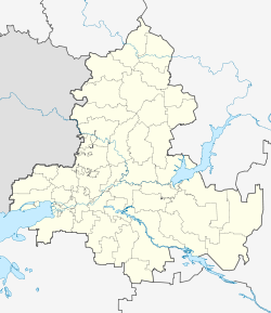
Oblivskaya
| Staniza
Oblivskaya
Oblivskaya
|
||||||||||||||||||||||||||||||||||
|
||||||||||||||||||||||||||||||||||
|
||||||||||||||||||||||||||||||||||
Obliwskaja ( Russian Обливская ) is a Staniza in the Rostov Oblast ( Russia ) with 9908 inhabitants (as of October 14, 2010).
geography
The village is located in the southern Russian steppe zone , about 250 km as the crow flies northeast of the Rostov-on-Don Oblast Administrative Center and 150 km west of Volgograd on the right bank of the right-hand Don tributary Tschir , which marks the border with Volgograd Oblast .
Obliwskaja is the administrative center of the Oblivsky Rajon named after her and the seat of the rural community Obliwskoje selskoje posselenije, which also includes the settlements (possjolok) Severny (4 km north) and Sredni Tschir (2 km north-west) and the hamlet (chutor) Dubowoi (17 km north-east) ), Gluchomanowski (12 km to the west), Kowylenski (7 km to the north-east), Ksyl-Aul (subsequently to the north-east), Lobachev (8 km to the west), Popow (13 km to the west-north-west), Ryabovsky (4 km to the west) ,kretev (13 km to the north-east ) and Senschin (8 km northeast) belong.
history
The stanitsa goes back to the hamlet (chutor) Obliwy founded by Cossacks in 1744 . From the end of the 18th century the village belonged to the land of the Don Army (from 1870 referred to as Oblast of the Don Army ), and within this, from the introduction of an administrative division in 1835, to the Second Don Okrug (Wtoroi Donskoi okrug) with headquarters in the scarce 50 km southeast situated Staniza Nizhne-Chirskaya (now Nizhny Chir ) as part of Tschernyschowskaja volost (whose seat Tschernyschowskaja is since 1957 Sovetskaya and is about 60 km away, north neighboring Rajonzentrum). By the end of the 19th century, the Obliwski name was already in use. During this time, the railway line from Lichaja (now part of Kamensk-Shakhtinsky ) to Tsaritsyn (later Stalingrad, now Volgograd), which started operating there in 1901, was passed. As a result, the importance and size of the place continued to grow; he was raised to Staniza, now under the current form of name, and no later than 1920 itself the seat of a Volost. In 1924, Oblivskaya became the administrative seat of a newly formed Rajon.
During the Second World War , Oblivskaya was occupied by the German Wehrmacht on July 30, 1942 while they were advancing on Stalingrad. The Wehrmacht operated a field airfield nearby. During Operation Uranus the Red Army to the encirclement of the German forces at Stalingrad the station and Staniza Obliwskaja came the front end of November 1942 temporarily in the area to a standstill. In the following weeks the place was fiercely contested, before it could be retaken by the Red Army on December 31st.
Population development
| year | Residents |
|---|---|
| 1897 | 1227 |
| 1939 | 5406 |
| 1959 | 5803 |
| 1970 | 7995 |
| 1979 | 8441 |
| 1989 | 9608 |
| 2002 | 9543 |
| 2010 | 9908 |
Note: census data
traffic
Oblivskaya is located on the Lichaya - Volgograd railway line (route km 209). About seven kilometers south-east, on the other bank of the Tschir, the federal highway A260 , part of the European route 40 , runs from the border with Ukraine to Volgograd. Regional road 60K-17 runs from Obliwskaya to the north, up the Tschir through the northeastern part of the oblast via the district centers of Sovetskaya and Bokovskaya to 60K-16, part of the Millerovo - Michailowka connection .
Individual evidence
- ↑ a b Itogi Vserossijskoj perepisi naselenija 2010 goda. Tom 1. Čislennostʹ i razmeščenie naselenija (Results of the All-Russian Census 2010. Volume 1. Number and distribution of the population). Tables 5 , pp. 12-209; 11 , pp. 312–979 (download from the website of the Federal Service for State Statistics of the Russian Federation)


