Tschaltyr
| Village
Chaltyr
Чалтырь
|
||||||||||||||||||||||||||||||
|
||||||||||||||||||||||||||||||
|
||||||||||||||||||||||||||||||
| List of large settlements in Russia | ||||||||||||||||||||||||||||||
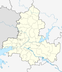
Tschaltyr ( Russian Ча́лтырь ) is a village (selo) in the Rostov Oblast in Russia with 15,334 inhabitants (as of October 14, 2010).
geography
The place is about 20 km as the crow flies northwest of the center of the Oblast capital Rostov-on-Don . It is located on the Mokry Chaltyr, a small tributary of the rightmost right arm of the Don Myortvy Donets, which flows a good 20 km west into the Sea of Azov .
Tschaltyr is the administrative center of the Rajons Mjasnikowski and seat the rural community Tschaltyrskoje selskoje posselenije, also the Weiler Mokry Tschaltyr (then almost immediately southwest) belongs to the. A large part of the inhabitants of the village as well as other places in the Rajon belong to the Armenian minority.
history
The place was founded in 1779 - in addition to the city of Nakhichevan on Don (Nor-Nakhichevan) and four other villages in the Rostov-on-Don area - by Armenians who, by ukase from Russian Empress Catherine II, as well as other Christian residents of the Crimea , how Greeks could settle in other parts of southern Russia. The current form of the name is derived from the original Armenian name Tschaltr ( Armenian Չալթր ).
In 1926 Tschaltyr came to the newly created Myasnikovsky rajon, named after the revolutionary and Soviet politician Alexander Myasnikov (1886–1925; actually Myasnikjan, an Armenian born in Nakhichevan), and after the incorporation of Nakhichevan into Rostov in 1928 it became the administrative seat of the Rajon.
During the Second World War , the place was occupied by the German Wehrmacht from November 17, 1941 to February 1943 .
Population development
| year | Residents |
|---|---|
| 1939 | 8,665 |
| 1959 | 7,983 |
| 1970 | 10,238 |
| 1979 | 10,924 |
| 1989 | 13,078 |
| 2002 | 14,711 |
| 2010 | 15,334 |
Note: census data
traffic
The federal highway A280 (formerly M23; also European route 58 ) runs on the southern edge of the place , which leads from Rostov along the north coast of the Azov Sea via Taganrog to the Ukrainian border.
About 3 km south of the town center, on the banks of the Don, is the Mokry Chaltyr station on the Moscow - Kharkiv - Taganrog - Rostov-on-Don railway line, electrified on this section since 1961 (line kilometer 1321), which is part of the most important connection in the Soviet Union Passenger traffic between Moscow and the Caucasus and the Caucasian Black Sea coast was. After the collapse of the Soviet Union , the route lost its importance to the eastern connection via Voronezh due to its route through Ukraine .
Chaltyr's sons and daughters
- Sarkis Saltykow (1905–1983), Armenian-Russian metallurgist and university professor
Web links
- Myasnikovsky rajon on the official website of the municipal formations of Rostov Oblast (Russian)
Individual evidence
- ↑ a b Itogi Vserossijskoj perepisi naselenija 2010 goda. Tom 1. Čislennostʹ i razmeščenie naselenija (Results of the All-Russian Census 2010. Volume 1. Number and distribution of the population). Tables 5 , pp. 12-209; 11 , pp. 312–979 (download from the website of the Federal Service for State Statistics of the Russian Federation)

