Kamenolomni
| Urban-type settlement
Kamenolomni
Каменоломни
|
||||||||||||||||||||||||||||||||||||
|
||||||||||||||||||||||||||||||||||||
|
||||||||||||||||||||||||||||||||||||
| List of large settlements in Russia | ||||||||||||||||||||||||||||||||||||
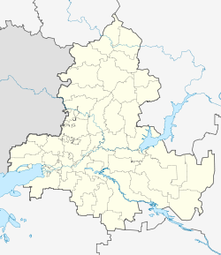
Kamenolomni ( Russian Каменоло́мни ) is an urban-type settlement in Rostov Oblast ( Russia ) with 11,247 inhabitants (as of October 14, 2010).
geography
The settlement is located a good 60 km northeast of the administrative center of Rostov-on-Don and around 3 km south of the center of the city of Shakhty , in fact directly adjacent to it. It is mainly located on the left bank of the Grushevka river , which flows over the Tuslow to the right Don arm Aksai near Novocherkassk , a good 30 km south .
Kamenolomni is the administrative center of the Rajons Oktyabrsky and seat and only town of the municipality Kamenolomenskoje gorodskoje posselenije.
history
In the hamlet (chutor) Maximowski , first mentioned in 1859 , the railway line ( Moscow -) Kozlov - Voronezh - Rostov-on-Don was passed by in 1863 and the Maximovka station opened there. In 1902 the station was renamed Kamenolomni , a now outdated Russian term for quarries (in the plural), some of which were operated in the area.
The hamlet, later also called Maximo-Novogruschewski together with the newly created neighboring village, received the status of an urban-type settlement in 1933 and its current name after the train station. Since 1938 the settlement has been the administrative seat of a Rajon.
Population development
| year | Residents |
|---|---|
| 1939 | 9,498 |
| 1959 | 15,447 |
| 1970 | 12,328 |
| 1979 | 12,221 |
| 1989 | 12,410 |
| 2002 | 12,281 |
| 2010 | 11,247 |
Note: census data
traffic
Kamenolomni is a larger station at kilometer 1141 of the Moscow - Rostov-on-Don railway line electrified on this section since 1962 .
The southern access road to Shakhty from the direction of Novocherkassk, which branches off a few kilometers south of Kamenolomni from the eastern continuation of the federal highway A270 (formerly M19) , runs through the settlement .
Individual evidence
- ↑ a b Itogi Vserossijskoj perepisi naselenija 2010 goda. Tom 1. Čislennostʹ i razmeščenie naselenija (Results of the All-Russian Census 2010. Volume 1. Number and distribution of the population). Tables 5 , pp. 12-209; 11 , pp. 312–979 (download from the website of the Federal Service for State Statistics of the Russian Federation)
Web links
- Municipality website (Russian)


