
Tatsinskaya
| Staniza
Tatsinskaya
Тацинская
|
||||||||||||||||||||||||||||||||||||||
|
||||||||||||||||||||||||||||||||||||||
|
||||||||||||||||||||||||||||||||||||||

.svg)

Tatsinskaya ( Russian Тацинская ) is a Staniza in the Rostov Oblast ( Russia ) with 9980 inhabitants (as of October 14, 2010).
geography
The village is located in the southern Russian steppe zone , about 160 kilometers as the crow flies northeast of the Rostov-on-Don Oblast Administrative Center and 10 kilometers east of the Bystraja , a left tributary of the Seversky Donets .
Tatsinskaya is the administrative center of the same named Rajons Tazinski and only destination in the rural community posselenije Tazinskoje selskoje.
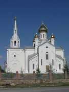
church
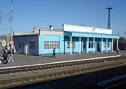
Train station


history
The Staniza goes back to a hamlet (chutor) founded in 1881 called Talowy (also Taly or Talowski ). In 1882, the Cossacks founded the Stanitsa Novo-Yermakovskaya ("New Yermakovskaya"; the eponymous Stanitsa Yermakovskaya, which was created in 1876, is a good 15 km south). Towards the end of the century, the railway line from Lichaya (now part of Kamensk-Shakhtinsky ) to Tsaritsyn (later Stalingrad, now Volgograd), which began operating in 1898, was passed. In June 1900 the Tazinskaya station was opened there, named after the local landowner Tazin. In the autumn of 1908, the settlement and hamlet that had grown near the station were combined with Stanitsa and renamed Tazinskaja . In the first decades of the 20th century, the place grew into a locally important traffic and trade center. In 1924 it became the administrative seat of a newly formed Rajon.
During the Second World War , Tazinskaya was occupied by the German Wehrmacht from summer to December 1942 , which operated an airfield there to supply the troops trapped in the Stalingrad pocket. On December 24th, the Red Army recaptured the site as part of their Middle Don Operation . One of the participating Soviet tank units was given the honorary name Tazinski Panzer Corps.
In 1959 Stanitsa received the status of an urban-type settlement under the name Tazinski. Since 1992 the place is again Staniza under the old name.
Population development
| year | Residents |
|---|---|
| 1897 | 483 |
| 1939 | 5,229 |
| 1959 | 9,200 |
| 1970 | 10,698 |
| 1979 | 10,433 |
| 1989 | 10,834 |
| 2002 | 11,275 |
| 2010 | 9,980 |
Note: census data
traffic
Tazinskaya is on the Lichaya - Volgograd railway line (100 km). The federal highway A260 , part of European route 40 , runs from the border with Ukraine to Volgograd about five kilometers to the north .
Individual evidence
- ↑ a b Itogi Vserossijskoj perepisi naselenija 2010 goda. Tom 1. Čislennostʹ i razmeščenie naselenija (Results of the All-Russian Census 2010. Volume 1. Number and distribution of the population). Tables 5 , pp. 12-209; 11 , pp. 312–979 (download from the website of the Federal Service for State Statistics of the Russian Federation)
Web links
- Local government website (Russian)
| Cities |
Aksai R | Azov S / R | Bataisk S | Belaya Kalitwa R | Donetsk S | Gukowo S | Kamensk-Shakhtinsky S | Konstantinovsk R | Krasny Sulin R | Millerowo R | Morozovsk R | Novoshakhtinsk S | Novocherkassk S | Proletarsk R | Rostov-on-Don S | Salsk R | Schachty S | Semikarakorsk R | Sernograd R | Swerewo S | Taganrog S | Volgodonsk S | Zimlyansk R |
|
| Urban-type settlements |
Gluboki R | Gorny | Kamenolomni R | Schirnow | Scholochowski | Uglerodowski | Ust-Donetsky R |
|
| Other Rajon centers |
Bagayevskaya | Bokovskaya | Bolshaya Martynovka | Dubovskoye | Egorlykskaya | Kagalnitskaya | Kazanskaya | Kaschary | Kuibyshevo | Matveev Kurgan | Milyutinskaya | Oblivskaya | Orlowski | Pestschanokopskoye | Pokrovskoye | Remontnoye | Rodionovo-Nesvetaiskaya | Romanovskaya | Sawetnoye | Simovniki | Sovetskaya | Tarassowski | Tatsinskaya | Tschaltyr | Chertkovo | Vessyoly | Vyoschenskaya | Zelina |