
Tsushima (island)
| Tsushima (island) | ||
|---|---|---|
 |
||
| Waters | Japanese sea | |
| Geographical location | 34 ° 25 ' N , 129 ° 20' E | |
|
||
| length | 70 km | |
| surface | 696.44 km² | |
| Highest elevation | Yatate 649 m |
|
| Residents | about 29,000 (October 1, 2019) 42 inhabitants / km² |
|
| main place | Tsushima | |

Tsushima ( Japanese 対 馬 ) is a Japanese island in the Sea of Japan .
geography
Tsushima is located in the Korea Strait and divides it into a western and an eastern channel. This eastern canal is also called Tsushima Strait. On the other side of Tsushima Strait lies the Japanese island of Kyūshū , on the other side of Korea Strait the Korean Peninsula . The island is located at the southernmost point of the Sea of Japan. Not far to the south, immediately after the two streets, the East China Sea begins . Of all the islands in the island state of Japan, Tsushima is the island that is closest to mainland Asia . The shortest distance from the island to the mainland is about 50 kilometers. The South Korean city of Busan is also located there .
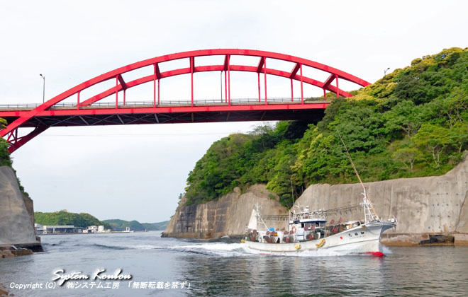
The 696.44 km² island of Tsushima consists of two main islands: Kami-jima ( 上 島 , "upper island") in the north and Shimo-jima ( 下 島 , "lower island") in the south. They are separated in the west by the deep Aso Bay ( 浅 茅 湾 ) and then by an approximately 50 meter wide sea channel. They are connected by a bridge over which the national road 382 runs. The 2 main islands are surrounded by 13 smaller islands. Together with the island of Iki , they form the Iki-Tsushima National Park .
The highest point is the Yatate ( 矢 立 山 , -yama , 34 ° 11 ′ N , 129 ° 14 ′ E ) on the island of Shimo-jima with 649 m. Other mountains are the Ariake ( 有 明 山 , -yama , 34 ° 12 ′ N , 129 ° 16 ′ E ) with 558 m, the Shira-dake ( 白 嶽 , 34 ° 16 ′ N , 129 ° 15 ′ E ) with 518 m and Mitake ( 雄岳 ) / Odake ( 御岳 ) ( 34 ° 34 ' N , 129 ° 23' O ) with 479 m on the island Kami-jima.
administration
Tsushima belongs to the Japanese prefecture of Nagasaki . Due to the remote location, however, many administrative functions are performed by the Tsushima regional office ( 対 馬 地方 局 , Tsushima chihō kyoku ) - until 2004 Tsushima sub-prefecture . The city of Tsushima (708.89 km²) includes since March 1, 2004 all localities on the island. Until then, the city of Izuhara was the main town on the island.
history
In 1019 the island was ravaged by Juerdschätischen and Korean pirates in the Toi invasion .
In 1274 and 1281, Tsushima was briefly captured during the First and Second Mongol invasion of Japan .
In 1861 the Russian Empire wanted to occupy the strategically important island. The Russian East Asia policy at that time aimed at a continental expansion of the Russian Empire in the Far East. After the British government protested against the annexation of the island, the Russian government abandoned this plan and withdrew.
On May 27, 1905, the sea battle near Tsushima took place in the waters around the island , in which the Japanese fleet defeated the Russian Baltic fleet.
From 1973 to 1998, Tsushima had a longitudinal wave transmitting antenna for the OMEGA navigation system .
On March 1, 2004, the villages and towns on the island were merged to form the town of the same name, Tsushima . Before unification, Izuhara was the largest city.
See also
literature
- Morinosuke Kajima: History of Japanese Foreign Relations. Volume 1: From the opening of the country to the Meiji restoration. Wiesbaden 1976, ISBN 3-515-02554-5 .
Individual evidence
- ↑ 島 面積 . (PDF; 136 kB) (No longer available online.) Kokudo Chiriin , October 1, 2015, archived from the original on June 15, 2016 ; Retrieved August 3, 2016 (Japanese). Info: The archive link was inserted automatically and has not yet been checked. Please check the original and archive link according to the instructions and then remove this notice.
- ↑ View from the sea to the bridge that connects the two halves of the island.
- ↑ 日本 の 主 な 山岳 標高 . Kokudo Chiriin, accessed February 25, 2009 (Japanese, Nagasaki Prefecture, must be clicked manually).
- ^ Philipp Franz von Siebold and Russian Policy and Action on Opening Japan to the West in the Middle of the Nineteenth Century by Edgar Franz, Iudicium Verlag, 2005, ISBN 3-89129-871-4
- ↑ SkyscraperPage.com : OMEGA Transmission Mast Shushi-Wan , accessed October 22, 2011